
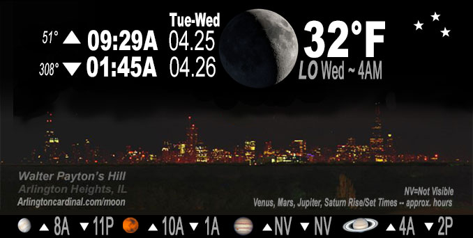
🌒 🌓 🌕 🌗 Waxing Crescent Moon, sky cover overnight Tue. to Wed. 11% to 5% to 25%, winds NE to NNE, 8 to 5 MPH, G16 to 14 MPH, 5p to 8p, Low 32, 4a to 6a
NWS CHGO | NWS HRLY | /NWSchicago | 🌡
ARLINGTON HEIGHTS WEATHER
▴ forecast7 (Arl. Hts.) | RADAR | WIDE RADAR
IMPORTANT NOTE ON NWS DATA
Hello mobile users! If you encounter a mobile “unfriendly” weather page, turn your phone sideways for a better view.
======================
NIGHT FORECASTS …
NOTE: Keep in mind lunar rise and set times don’t always correspond with night weather and early morning lows because on some days during the month the moon is visible in the sky predominantly during the daytime hours.
Overnight Tuesday/Wednesday …
Weather Hazards expected …
Elevated Frost and Freeze Risk late tonight. Frost observed on car windows.
DISCUSSION…
Temperatures are expected to drop into the lower and middle 30s Tuesday night and Wednesday night away from the heart of the Chicago urban area and the immediate Lake Michigan shore. Also, areas of frost are likely in these areas from late Wednesday night through sunrise Thursday.
======================
O’HARE FORECAST …
Forecast Beginning Tuesday Night, Apr. 25, 2023 …
Tuesday: Widespread frost, mainly between midnight and 5am. Otherwise, mostly clear, with a low around 34. North wind 5 to 10 mph, with gusts as high as 15 mph.
Wednesday: Areas of frost before 8am. Otherwise, sunny, with a high near 51. East northeast wind 5 to 10 mph.
Wednesday Night: Areas of frost after 4am. Otherwise, mostly clear, with a low around 37. Southeast wind around 5 mph, with gusts as high as 10 mph.
Thursday: Areas of frost before 7am. Otherwise, sunny, with a high near 64. South southeast wind 5 to 10 mph, with gusts as high as 15 mph.
Thursday Night: A 20 percent chance of showers after 1am. Mostly cloudy, with a low around 45.
Friday: A 20 percent chance of showers. Partly sunny, with a high near 63.
Friday Night: A chance of showers. Mostly cloudy, with a low around 44.
Saturday: Showers likely, mainly after 1pm. Mostly cloudy, with a high near 58.
Saturday Night: Showers likely. Mostly cloudy, with a low around 43.
Sunday: Showers likely. Mostly cloudy, with a high near 53.
Sunday Night: A chance of showers. Mostly cloudy, with a low around 40.
Monday: A chance of showers. Mostly cloudy, with a high near 51. Breezy.
O’Hare forecast archive and hourly weather observations archive are available HERE on the CARDINAL NEWS Magazine.
Arlingtoncardinal.com/moonphases
Arlingtoncardinal.com/nightsky
NIGHT SKY THIS MONTH …
Check the night sky objects for this month and past months in the playlist from the Space Telescope Science Institute YouTube channel Backyard stargazers get a monthly guide to the northern hemisphere’s skywatching events with “Tonight’s Sky” (Musical track The Far River written by Jonn Serrie, from the album And the Stars Go With You courtesy of New World Music Ltd. Musical track The Far River written by Jonn Serrie, from the album And the Stars Go With You courtesy of New World Music Ltd).
Telephoto lens, ISO 100, f/11, Shutter Speed 1/100 to 1/125 for the Moon.
Get updates from The Cardinal ALL NEWS FEEDS on Facebook. Just ‘LIKE’ the ‘Arlington Cardinal Page (become a fan of our page). The updates cover all posts and sub-category posts from The Cardinal — Arlingtoncardinal.com. You can also limit feeds to specific categories. See all of The Cardinal Facebook fan pages at Arlingtoncardinal.com/about/facebook …
Help fund The Cardinal Arlingtoncardinal.com/sponsor
Telephoto lens, ISO 1600, f/11, Shutter Speed 2.5″ for the skyline. The skyline exposure was toned down, and brightness and contrast was adjusted in Photoshop.
/////////////>
Area Forecast Discussion
National Weather Service Chicago/Romeoville, IL
1245 AM CDT Wed Apr 26 2023
.SHORT TERM… Issued at 225 PM CDT Tue Apr 25 2023
Through Wednesday night…
Frost/freeze headlines are in effect for all but the core of the Chicago metro and near shoreline locations tonight. The persistent cold air mass combined with gradual drying from advection and ongoing daytime mixing will continue to erode cloud cover across the area through this evening. In fact, lowering inversion heights from the north have suppressed convective cloud depths enough that much of the existing cloud cover is mostly diurnal driven outside of far northern IL into southeast WI (where the chance for a few sprinkles remains into early evening). Gradient flow potentially remaining above 5 knots will put a limit on low temps, but with generally clear skies the expectation is for substantial decoupling late tonight. The most concern for hard-freeze conditions with temps in the upper 20s is west of the Fox River Valley and north of I-80. A southeastward tiered headline approach follows, with a more marginal Freeze Warning from the Illinois River Valley into the west and southwest suburbs, and a Frost Advisory into east-central IL and northwest IN (per discussion to resume Frost Advisories with surrounding offices). NNE flow off Lake Michigan will slightly elevate dew points and support enough air moderation to limit frost/freeze potential along the immediate shore and through the core of the Chicago metro.
Surface high pressure will brush the CWA to the northeast on Wednesday before a retreating ridge extends across the area Wednesday night. Dry conditions and mostly sunny conditions will prevail during the day with the exception of some diurnal cumulus north. Frost conditions will likely exist again Wednesday night, though veering and increasing low-level flow should keep temps above freezing area-wide.
Kluber/NWS Chicago
