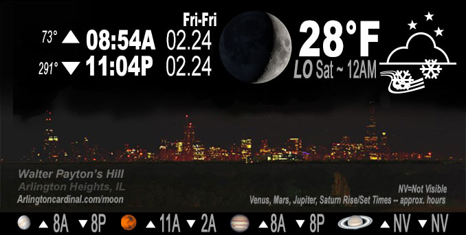
🌒 🌓 🌕 🌗 Waxing Crescent Moon, snow flurries, sky cover overnight Fri. to Sat. 79% to 81% to 48%, winds ENE to NW to SE to SW to WSW, 6 to 10 to 2 to 5 MPH, Low 28, 12a to 7a
NWS CHGO | NWS HRLY | /NWSchicago | 🌡
ARLINGTON HEIGHTS WEATHER
▴ forecast7 (Arl. Hts.) | RADAR | WIDE RADAR
IMPORTANT NOTE ON NWS DATA
======================
NIGHT FORECASTS …
NOTE: Keep in mind lunar rise and set times don’t always correspond with night weather and early morning lows because on some days during the month the moon is visible in the sky predominantly during the daytime hours.
Overnight Friday/Saturday …
No Weather Hazards expected
Compared to this morning, warmer low temperature of 28°F from midnight Friday/Saturday until 7:00 a.m. Saturday.
DISCUSSION…
Outside the low-end chances for flurries Friday night until 4:00 a.m. Saturday. There are no weather concerns in the short-term period. Easterly winds will gradually veer around the clock tonight and become west to southwesterly tomorrow. Clearing skies and gradually increasing low-level WAA (Warm Air Advection) will support warming temperatures with highs in the upper 30s to lower 40s.
Hello mobile users! If you encounter mobile “unfriendly” weather page, turn your phone sideways for a better view.
======================
O’HARE FORECAST …
Forecast Beginning Friday Night, Feb. 24, 2023 …
Friday Night: A slight chance of snow showers before 2am, then a slight chance of flurries after 2am. Mostly cloudy, with a low around 26. East wind 5 to 10 mph becoming light and variable after midnight. Chance of precipitation is 20%.
Saturday: Mostly sunny, with a high near 39. West wind 5 to 10 mph.
Saturday Night: Mostly clear, with a low around 29. West southwest wind around 10 mph, with gusts as high as 20 mph.
Sunday: Sunny, with a high near 50. West southwest wind around 5 mph becoming southeast in the afternoon. Winds could gust as high as 10 mph.
Sunday Night: Rain, mainly after 1am. Low around 38. Chance of precipitation is 90%.
Monday: Rain, mainly before 1pm. High near 56. Breezy. Chance of precipitation is 100%.
Monday Night: A chance of rain before 7pm. Mostly cloudy, with a low around 33. Breezy.
Tuesday: Mostly sunny, with a high near 47.
Tuesday Night: Mostly cloudy, with a low around 36.
Wednesday: A chance of rain. Mostly cloudy, with a high near 50.
Wednesday Night: A chance of rain. Mostly cloudy, with a low around 32.
Thursday: Partly sunny, with a high near 40.
O’Hare forecast archive and hourly weather observations archive are available HERE on the CARDINAL NEWS Magazine.
Arlingtoncardinal.com/moonphases
Arlingtoncardinal.com/nightsky
NIGHT SKY THIS MONTH …
Check the night sky objects for this month and past months in the playlist from the Space Telescope Science Institute YouTube channel Backyard stargazers get a monthly guide to the northern hemisphere’s skywatching events with “Tonight’s Sky” (Musical track The Far River written by Jonn Serrie, from the album And the Stars Go With You courtesy of New World Music Ltd. Musical track The Far River written by Jonn Serrie, from the album And the Stars Go With You courtesy of New World Music Ltd).
Telephoto lens, ISO 100, f/11, Shutter Speed 1/100 to 1/125 for the Moon.
Get updates from The Cardinal ALL NEWS FEEDS on Facebook. Just ‘LIKE’ the ‘Arlington Cardinal Page (become a fan of our page). The updates cover all posts and sub-category posts from The Cardinal — Arlingtoncardinal.com. You can also limit feeds to specific categories. See all of The Cardinal Facebook fan pages at Arlingtoncardinal.com/about/facebook …
Help fund The Cardinal Arlingtoncardinal.com/sponsor
Telephoto lens, ISO 1600, f/11, Shutter Speed 2.5″ for the skyline. The skyline exposure was toned down, and brightness and contrast was adjusted in Photoshop.
Area Forecast Discussion
National Weather Service Chicago/Romeoville, IL
105 PM CST Fri Feb 24 2023
.SHORT TERM… Issued at 105 PM CST Fri Feb 24 2023
Through Saturday night…
The upper-level pattern remains energetic and within a -PNA regime with deep troughing entrenched across the Pacific coast of the US and a rippin` upper-level jet stream across the central US (the 12Z DVN RAOB sampled 180kt of flow at 250mb). The only focus in the short-term period is on a subtle vort max propagating within broad upper-level southwesterly flow toward the Great Lakes. As modest DCVA spreads across the Great Lakes this evening ahead of the wave, expansive virga currently over Iowa will expand eastward in tandem with thickening upper-level clouds. The low-level airmass remains effectively parched (recent AMDAR soundings sampled a ~7000 ft layer where the RH ranged between 15-35% beneath upper-level cloud bases), though with time a few flurries or even brief snow showers may break through particularly between 6 PM and midnight. For now, opted to maintain low-end PoPs (15-20%) for snow showers generally along and north of I-88. Meanwhile, modest WAA across the mid-Mississippi River Valley should encourage a few showers to develop toward midnight, particularly south of I-80. Precipitation type with any WAA-driven shower may end up as a low-quality snow grain (in-cloud temperatures hover between -9 to -10C), or even a patch of freezing drizzle. At this point, coverage, longevity, and intensity of precipitation does not seem nearly high enough to lead to any impacts within either regime.
Outside the low-end chances for flurries tonight, there are no weather concerns in the short-term period. Easterly winds will gradually veer around the clock tonight and become west to southwesterly tomorrow. Clearing skies and gradually increasing low- level WAA will support warming temperatures with highs in the upper 30s to lower 40s.
Borchardt/NWS Chicago
308 AM CST Sat Feb 25 2023
.SHORT TERM… Issued at 308 AM CST Sat Feb 25 2023
Through Sunday…
Remnant overcast skies continue this morning across the Midwest, as High pressure off the southern Florida coast ushers additional moisture through the southern Plains into the mid-Mississippi River Valley. Question of today will be how much we can erode the clouds, with the potential for late day clearing. With saturation well to the north in Wisconsin from snowpack, expecting clouds to linger north of the area, as depicted on current satellite analysis. Additional building of the cloud deck continues back into far northern Iowa, however there should remain a steady back edge that tracks into northern Illinois towards the Chicago metro today. The overcast conditions will also play a role in the amount of warmup across the region today, where temps are now forecast in the 30s to low 40s.
Heading into the overnight, sfc High pressure slides towards the southeast US, bringing the return of sw`erly winds. Continuation of upper level zonal flow, ahead of the next weather system, will bring about breezy wind gusts tonight…with gusts north of I-80 in the 15-25kt range. Held off on any lake products, as it appears winds will remain just below advisory criteria.
Moving into Sunday, temps climb through the morning then cool during the afternoon as winds turn more ese. This could bring about a rare cool season lake breeze near the shores of Lake Michigan. Due to this, went ahead and cooled the nearshore temps across the Illinois portion of the lake during Sunday afternoon into the evening. Otherwise, across the inland portions of Illinois, robust warm advection will be increasing through Sunday evening in advance of a potent storm system which will be rolling east across the Central Plains.
Baker/NWS Chicago