
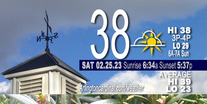
Saturday Hi 38, mostly cloudy to partly cloudy skies, winds WSW to SW, 5 to 11 MPH, G13 to 21 to 13 MPH end 5a Sun.
NWS CHGO | NWS HRLY | /NWSchicago | 🌡
ARLINGTON HEIGHTS WEATHER
▴ forecast7 (Arl. Hts.) | RADAR | WIDE RADAR
⏪ Hrly Data Table | Hrly Future Graph ⏩
IMPORTANT NOTE ON NWS DATA
⏪ Hrly Data Table | Hrly Future Graph ⏩
======================
Saturday and Saturday Evening …
No Weather Hazards expected …
However, be prepared …
Hydrologic Outlook from yesterday, Friday
National Weather Service Chicago IL
220 PM CST Fri Feb 24 2023
…Heavy Rainfall and Rises in River Levels Possible Next Week…
Rainfall, heavy at times, is expected on Monday across parts of northern Illinois and northwestern Indiana. Local areas may receive rainfall amounts high enough to cause river rises, widespread ponding of water, and localized flooding.
After a recent soaking rainfall and freezing temperatures, soil moisture is nearly ubiquitously above average in northern Illinois and northwestern Indiana. The current forecast of 1 to 2 inches of rainfall may cause river stages to rise to near or above bankfull, particularly along the Fox, Des Plaines, Rock, and Kankakee River Basins. With already-elevated river stages along the Iroquois and Illinois river basins, even limited rainfall amounts may cause stages to rise near bankfull. The exact river basins that will see near flood stage conditions is heavily dependent on the location of heavy rainfall.
This outlook means that elevated water levels and flooding impacts are possible, but not yet certain. Persons should closely monitor forecasts including the possibility of flood watches, warnings, and advisories.
DISCUSSION…
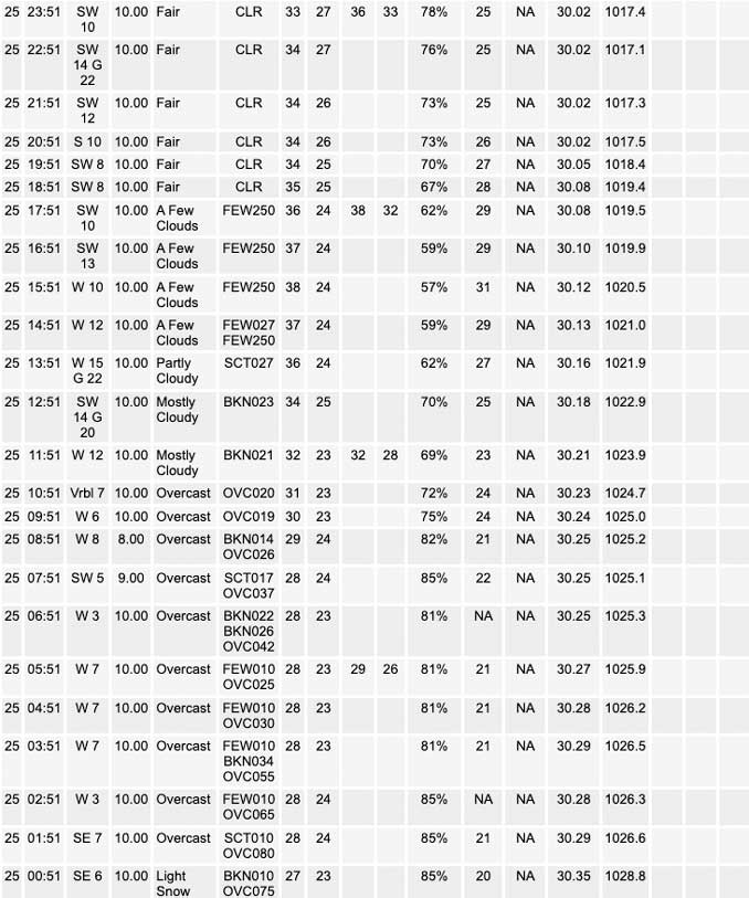
Remnant overcast skies continue this morning across the Midwest, as High pressure off the southern Florida coast ushers additional moisture through the southern Plains into the mid-Mississippi River Valley. Question of today will be how much we can erode the clouds, with the potential for late day clearing. With saturation well to the north in Wisconsin from snowpack, expecting clouds to linger north of the area, as depicted on current satellite analysis. Additional building of the cloud deck continues back into far northern Iowa, however there should remain a steady back edge that tracks into northern Illinois towards the Chicago metro today. The overcast conditions will also play a role in the amount of warmup across the region today, where temps are now forecast in the 30s to low 40s.
Daily low temperatures and daily high temperatures are on the way up. We’re gaining about 2 or 3 minutes of daylight every day in the progression toward vernal equinox, March 20, 2023.
======================
O’HARE FORECAST …
Forecast Beginning Saturday, Feb. 25, 2023
Saturday: Mostly cloudy, then gradually becoming sunny, with a high near 39. West wind 5 to 10 mph, with gusts as high as 15 mph.
Saturday Night: Mostly clear, with a low around 28. West southwest wind 5 to 10 mph, with gusts as high as 20 mph.
Sunday: Sunny, with a high near 48. West southwest wind around 5 mph becoming east southeast in the afternoon. Winds could gust as high as 10 mph.
Sunday Night: Rain, mainly after midnight. Low around 34. Breezy, with an east southeast wind 5 to 10 mph increasing to 15 to 20 mph after midnight. Winds could gust as high as 30 mph. Chance of precipitation is 100%.
Monday: Rain, mainly before noon. High near 56. Breezy, with an east southeast wind 15 to 25 mph becoming west in the afternoon. Winds could gust as high as 35 mph. Chance of precipitation is 90%.
Monday Night: Mostly cloudy, with a low around 34. Breezy.
Tuesday: Mostly sunny, with a high near 48.
Tuesday Night: A chance of rain after midnight. Mostly cloudy, with a low around 37.
Wednesday: A chance of rain after noon. Partly sunny, with a high near 54.
Wednesday Night: Mostly cloudy, with a low around 33.
Thursday: Mostly cloudy, with a high near 40.
Thursday Night: A chance of snow. Mostly cloudy, with a low around 26.
Friday: Mostly sunny, with a high near 42.


CHICAGOWEATHERSTATION.COM

ChicagoWeatherStation.com I O’Hare Normal Temps/Precip I O’Hare Record Temps, Precip, Snow
LIVE RADAR | STORM TRACKS | UNISYS US IR SAT | UNISYS Midwest IR SAT | UNISYS More IR SAT
WunderMap® with Temperature/Wind Data || Google: Arlington Heights Area Temps | US TEMPS
Full Screen Motion Weather Radar (Wunderground.com)
Midwest Cloud Cover with Arlington Heights Weather Forecast
ChicagoWeatherStation.com I O’Hare Normal Temps/Precip I O’Hare Record Temps, Precip, Snow
SUNLIGHT DATA FOR SECURITY, TRAFFIC SAFETY, AND SPORTS
SunCalc.net data with solar azimuth and trajectory, times for dawn, sunrise, solar noon, sunset, dusk …
NIGHT SKY THIS MONTH …
Backyard stargazers get a monthly guide to the northern hemisphere’s skywatching events with “Tonight’s Sky.” Check the night sky objects for this month and past months in the playlist from the Space Telescope Science Institute YouTube channel (Musical track The Far River written by Jonn Serrie, from the album And the Stars Go With You courtesy of New World Music Ltd).
Get updates from The Cardinal ALL NEWS FEEDS on Facebook. Just ‘LIKE’ the ‘Arlington Cardinal Page (become a fan of our page). The updates cover all posts and sub-category posts from The Cardinal — Arlingtoncardinal.com. You can also limit feeds to specific categories. See all of The Cardinal Facebook fan pages at Arlingtoncardinal.com/about/facebook …
Help fund The Cardinal Arlingtoncardinal.com/sponsor
Area Forecast Discussion
National Weather Service Chicago/Romeoville, IL
538 AM CST Sat Feb 25 2023
.SHORT TERM… Issued at 308 AM CST Sat Feb 25 2023
Through Sunday…
Remnant overcast skies continue this morning across the Midwest, as High pressure off the southern Florida coast ushers additional moisture through the southern Plains into the mid-Mississippi River Valley. Question of today will be how much we can erode the clouds, with the potential for late day clearing. With saturation well to the north in Wisconsin from snowpack, expecting clouds to linger north of the area, as depicted on current satellite analysis. Additional building of the cloud deck continues back into far northern Iowa, however there should remain a steady back edge that tracks into northern Illinois towards the Chicago metro today. The overcast conditions will also play a role in the amount of warmup across the region today, where temps are now forecast in the 30s to low 40s.
Heading into the overnight, sfc High pressure slides towards the southeast US, bringing the return of sw`erly winds. Continuation of upper level zonal flow, ahead of the next weather system, will bring about breezy wind gusts tonight…with gusts north of I-80 in the 15-25kt range. Held off on any lake products, as it appears winds will remain just below advisory criteria.
Moving into Sunday, temps climb through the morning then cool during the afternoon as winds turn more ese. This could bring about a rare cool season lake breeze near the shores of Lake Michigan. Due to this, went ahead and cooled the nearshore temps across the Illinois portion of the lake during Sunday afternoon into the evening. Otherwise, across the inland portions of Illinois, robust warm advection will be increasing through Sunday evening in advance of a potent storm system which will be rolling east across the Central Plains.
Baker/NWS Chicago
