
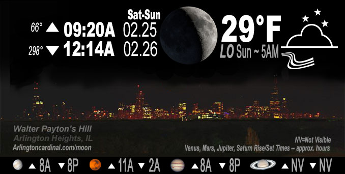
🌒 🌓 🌕 🌗 Waxing Crescent Moon, sky cover overnight Sat. to Sun. 3% to 8% to 10%, winds SW to S to SW to S to SW, 10 to 14 to 3 MPH, G 22 MPH at 11p, Low 28, 6a to 7a
NWS CHGO | NWS HRLY | /NWSchicago | 🌡
ARLINGTON HEIGHTS WEATHER
▴ forecast7 (Arl. Hts.) | RADAR | WIDE RADAR
IMPORTANT NOTE ON NWS DATA
======================
NIGHT FORECASTS …
NOTE: Keep in mind lunar rise and set times don’t always correspond with night weather and early morning lows because on some days during the month the moon is visible in the sky predominantly during the daytime hours.
Overnight Saturday/Sunday …
No Weather Hazards expected
Quiet overnight with a second day with a low of 28°F from midnight Friday/Saturday until 7:00 a.m. Saturday.
DISCUSSION…
Quiet weather in the immediate short term is the key message, with milder air on Sunday although an atypical wintertime lake breeze will keep lakeside locations cooler. Clearing of the stratocumulus continues with dry advection from the west-southwest, and the entire area should be void of these by sunset, and remain clear overnight Saturday to Sunday.
Hello mobile users! If you encounter mobile “unfriendly” weather page, turn your phone sideways for a better view.
======================
O’HARE FORECAST …
Forecast Beginning Saturday Night, Feb. 25, 2023 …
Saturday Night: Mostly clear, with a low around 28. West southwest wind 5 to 10 mph, with gusts as high as 20 mph.
Sunday: Sunny, with a high near 48. West southwest wind around 5 mph becoming east southeast in the afternoon. Winds could gust as high as 10 mph.
Sunday Night: Rain, mainly after midnight. Low around 34. Breezy, with an east southeast wind 5 to 10 mph increasing to 15 to 20 mph after midnight. Winds could gust as high as 30 mph. Chance of precipitation is 100%.
Monday: Rain, mainly before noon. High near 56. Breezy, with an east southeast wind 15 to 25 mph becoming west in the afternoon. Winds could gust as high as 35 mph. Chance of precipitation is 90%.
Monday Night: Mostly cloudy, with a low around 34. Breezy.
Tuesday: Mostly sunny, with a high near 48.
Tuesday Night: A chance of rain after midnight. Mostly cloudy, with a low around 37.
Wednesday: A chance of rain after noon. Partly sunny, with a high near 54.
Wednesday Night: Mostly cloudy, with a low around 33.
Thursday: Mostly cloudy, with a high near 40.
Thursday Night: A chance of snow. Mostly cloudy, with a low around 26.
Friday: Mostly sunny, with a high near 42.
O’Hare forecast archive and hourly weather observations archive are available HERE on the CARDINAL NEWS Magazine.
Arlingtoncardinal.com/moonphases
Arlingtoncardinal.com/nightsky
NIGHT SKY THIS MONTH …
Check the night sky objects for this month and past months in the playlist from the Space Telescope Science Institute YouTube channel Backyard stargazers get a monthly guide to the northern hemisphere’s skywatching events with “Tonight’s Sky” (Musical track The Far River written by Jonn Serrie, from the album And the Stars Go With You courtesy of New World Music Ltd. Musical track The Far River written by Jonn Serrie, from the album And the Stars Go With You courtesy of New World Music Ltd).
Telephoto lens, ISO 100, f/11, Shutter Speed 1/100 to 1/125 for the Moon.
Get updates from The Cardinal ALL NEWS FEEDS on Facebook. Just ‘LIKE’ the ‘Arlington Cardinal Page (become a fan of our page). The updates cover all posts and sub-category posts from The Cardinal — Arlingtoncardinal.com. You can also limit feeds to specific categories. See all of The Cardinal Facebook fan pages at Arlingtoncardinal.com/about/facebook …
Help fund The Cardinal Arlingtoncardinal.com/sponsor
Telephoto lens, ISO 1600, f/11, Shutter Speed 2.5″ for the skyline. The skyline exposure was toned down, and brightness and contrast was adjusted in Photoshop.
Area Forecast Discussion
National Weather Service Chicago/Romeoville, IL
201 PM CST Sat Feb 25 2023
.SHORT TERM… Issued at 159 PM CST Sat Feb 25 2023
Through Sunday…
Quiet weather in the immediate short term is the key message, with milder air on Sunday although an atypical wintertime lake breeze will keep lakeside locations cooler.
Clearing of the stratocumulus continues with dry advection from the west-southwest, and the entire area should be void of these by sunset. A low amplitude wave traversing the northern jet stream across far southern Canada will deepen a surface low to near 1004 mb north of Lake Superior tonight. The envelope of a tightened pressure gradient will seep into the area this evening. So after an early evening drop in wind speeds and temperatures, the winds should inch back up with temperatures leveling off or even also creeping up. With the quick speed of the system, the wind does look to dissipate in the pre-dawn to daybreak time, allowing for temperatures to drop back with some near 20F lows possible north.
The 925 mb temperatures will have increased from -6C today to +2C for Sunday, aided by the southwest low-level jet tonight into early Sunday morning. Climatology says for those values this time of year without snow cover that highs should be in the 50s. We undercut that some with an inversion expected to start the day and mid/high cloud possible in the afternoon. Also, confidence is high in a lake breeze due to the light synoptic winds of high pressure passing overhead and the density difference of mid 30s over the lake vs well into the 40s to low 50s inland. This lake breeze should cool lake adjacent areas from the 40s by midday to mid 30s just an hour or two later.
MTF/NWS Chicago
304 AM CST Sun Feb 26 2023
.SHORT TERM… Issued at 251 AM CST Sun Feb 26 2023
Through Monday Night…
The key weather messages through Monday night are:
* Period of widespread–at times briefly heavy–rainfall and isolated embedded thunderstorms late tonight into Monday morning. Ponding on roadways and threat for river rises.
* Increasing concern for a brief severe weather potential early Monday morning, mainly south of the Kankakee River. Severe- caliber wind gusts and even a few brief mesovortex tornadoes possible in the 6-10/7-11 AM timeframe.
* “Pop” of winds immediately behind convection south of I-80 Monday morning, followed by more widespread 40-45 mph gusts late Monday afternoon and evening. Wind advisories possible, although confidence a bit too low for issuance on this shift.
Our weather will be turning notably more active as a potent system slices across the Great Lakes region late tonight into Monday. In the meantime, quiescent conditions will continue, with today looking very pleasant with a good deal of sunshine under occasional tufts of high cloud cover. 925 mb temperature climatology continues to support highs climbing into the 50s across the southern half of our area, and this continues to look reasonable, except for lake-adjacent locales where a lake breeze looks set to charge inland thanks to nearly 20 degree lake-land delta Ts. This will drive sharply-falling temperatures this afternoon and will also hold immediate lakeside locales in the 30s.
Moisture channel loops reveal our disturbance in question for tonight–which has been responsible for extraordinarily anomalous precipitation and winter-related weather impacts–pinwheeling across southern California. An associated jet streak can be seen blasting across the Baja Peninsula and the Sonora Desert, and as the nose of this feature impinges upon the Continental Divide, rapid lee cyclogenesis will get underway later this afternoon and evening. Stout poleward moisture fluxes will drive a quick increase in precipitation coverage late tonight, and pockets of elevated instability support a continued mention of a few embedded storms. Fast forward nature of the incoming low–which will be an impressive 980s mb feature–will thankfully limit residence time of heavier precipitation rates. That said, the favorable spatiotemporal overlap of deep/intense moisture transport and an intensely-diffluent upper jet portends a 4-6 hour window early Monday morning with widespread steady to locally heavy rainfall followed by lighter, more showery precipitation into the afternoon. Overall, QPF guidance has trended perhaps a smidge downwards, but still a good signal for widespread amounts of 0.5-1 inch with isolated swaths of 2 inch amounts before all is said and done.
Of a bit more concern are trends in model guidance regarding the severe potential Monday morning. While the time of day is climatologically unfavorable for severe weather in our area, the presence of intense moisture transport guiding mid 50s dewpoints across central Illinois into a strongly-sheared environment is usually cause for some concern this time of year. A very tiny/narrow warm sector looks to impinge into our southern locales after about 6 AM Monday. While the steepest low-level lapse rates will trail the cold front and associated occlusion, guidance continues to advertise a notable cooling of 700 mb temperatures atop the front, with associated increases in available CAPE. Just how much of this is available for surface parcels remains in question, but strongly-forced lines and slab- like ascent in advance can pretty easily erode marginal SBCIN. Indeed, seeing signals for this in incoming hires guidance. While the more appreciable severe threat may remain relegated farther south amidst deeper moisture, we did coordinate with SPC to expand the level 1/5 (Marginal) delineation northward into our far south Monday morning. If surface-based convective elements materialize, an attendant threat for fingers of severe wind gusts and even a few brief spin-up mesovortex tornadoes would be possible. The main window for this threat is maybe 6-10/7-11 AM south of the Kankakee River.
Additionally, looking like a “pop” of strong southwesterly winds could occur immediately behind this line in response to pressure rises and steepening lapse rates within an initial zone of cold advection, mainly for areas well south of I-80. This wind response may be pretty ephemeral, however, as 925-850 mb winds ease temporarily as the main low trundles overhead. A secondary and more widespread push of cold advection looks to develop through late Monday afternoon and evening, and as this occurs, gusty W/NW winds will become more prevalent across most of the forecast area. Presence of low stratus continues to be a wild card with its impacts on the depth of PBL mixing in question. For the time being, elected to hold off on any wind headlines given lingering uncertainties. Either way, looks windy headed into Monday evening, with gusts up to 45 mph possible.
Otherwise, isolated/scattered showers will dwindle through Monday evening. Northwesterly breezes will usher in a cooler airmass with temperatures expected to fall back into the 30s into Tuesday morning.
Carlaw/NWS Chicago
