
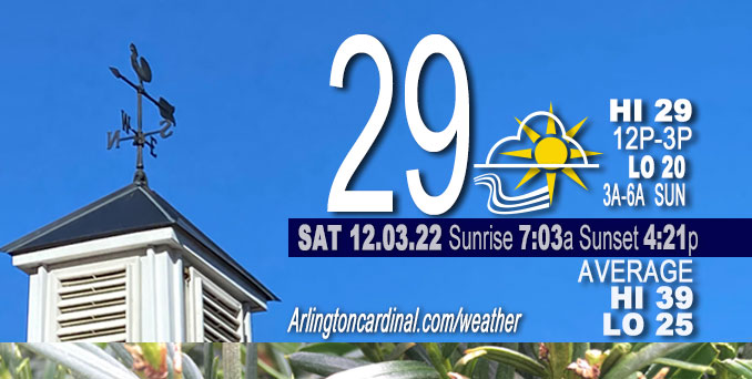
SATURDAY Hi 29, mostly sunny, winds WNW to W to WSW, 18 to 8 MPH, G25 to 13 MPH ending at 9p
NWS CHGO | NWS HRLY | /NWSchicago | 🌡
ARLINGTON HEIGHTS WEATHER
▴ forecast7 (Arl. Hts.) | RADAR | WIDE RADAR
⏪ Hrly Data Table | Hrly Future Graph ⏩
IMPORTANT NOTE ON NWS DATA
⏪ Hrly Data Table | Hrly Future Graph ⏩
======================
Saturday and Saturday Night …
No Weather Hazards expected…
DISCUSSION…
Sunshine returns Saturday, but it won’t provide much warmth with overriding blustery winds from the west-northwest and then west-southwest. Daytime temperatures in the 20s to around 30 and wind chills in the teens are forecast this afternoon. Strong 1035 mb high pressure is building across the lower Missouri and Ohio Valleys tonight. The forecast area remains on the northern periphery of the surface ridge, so winds don`t look to fall off completely tonight. In fact, Sunday looks somewhat blustery again as the gradient north of the Ohio Valley high pressure ridge tightens up a bit in response to another low pressure area moving across Ontario during the day. Temperatures are expected to moderate into the upper 30s in most spots by afternoon under mostly sunny skies, though upper 20s/around 30 wind chills will make it feel colder with winds gusting 20-25 mph at times.
DuPage Airport reported a gust of 50 MPH early Saturday morning around 1:30 a.m., while O’Hare and Midway reported gusts just over 46 MPH. Winds were from the southwest and then the west overnight — shifting from southwest to west around the time the big gusts came through.
Hello mobile users! If you encounter mobile “unfriendly” weather page, turn your phone sideways for a better view.
======================
O’HARE FORECAST …
Forecast Beginning Saturday, Dec. 03, 2022
Saturday: Sunny, with a high near 29. Blustery, with a west northwest wind 10 to 20 mph, with gusts as high as 25 mph.
Saturday Night: Mostly clear, with a low around 20. West wind 5 to 10 mph, with gusts as high as 15 mph.
Sunday: Sunny, with a high near 39. Southwest wind 10 to 15 mph, with gusts as high as 25 mph.
Sunday Night: Partly cloudy, with a low around 28. Southwest wind around 10 mph, with gusts as high as 15 mph.
Monday: A 20 percent chance of rain after noon. Mostly cloudy, with a high near 43. South southwest wind 10 to 15 mph, with gusts as high as 20 mph.
Monday Night: Mostly cloudy, with a low around 28.
Tuesday: Mostly cloudy, with a high near 39.
Tuesday Night: A chance of rain before midnight. Mostly cloudy, with a low around 32.
Wednesday: Partly sunny, with a high near 42.
Wednesday Night: Mostly cloudy, with a low around 30.
Thursday: Mostly cloudy, with a high near 41.
Thursday Night: A chance of snow. Mostly cloudy, with a low around 31.
Friday: A chance of snow. Partly sunny, with a high near 40.


CHICAGOWEATHERSTATION.COM

ChicagoWeatherStation.com I O’Hare Normal Temps/Precip I O’Hare Record Temps, Precip, Snow
LIVE RADAR | STORM TRACKS | UNISYS US IR SAT | UNISYS Midwest IR SAT | UNISYS More IR SAT
WunderMap® with Temperature/Wind Data || Google: Arlington Heights Area Temps | US TEMPS
Full Screen Motion Weather Radar (Wunderground.com)
Midwest Cloud Cover with Arlington Heights Weather Forecast
ChicagoWeatherStation.com I O’Hare Normal Temps/Precip I O’Hare Record Temps, Precip, Snow
SUNLIGHT DATA FOR SECURITY, TRAFFIC SAFETY, AND SPORTS
SunCalc.net data with solar azimuth and trajectory, times for dawn, sunrise, solar noon, sunset, dusk …
NIGHT SKY THIS MONTH …
Backyard stargazers get a monthly guide to the northern hemisphere’s skywatching events with “Tonight’s Sky.” Check the night sky objects for this month and past months in the playlist from the Space Telescope Science Institute YouTube channel (Musical track The Far River written by Jonn Serrie, from the album And the Stars Go With You courtesy of New World Music Ltd).
Get updates from The Cardinal ALL NEWS FEEDS on Facebook. Just ‘LIKE’ the ‘Arlington Cardinal Page (become a fan of our page). The updates cover all posts and sub-category posts from The Cardinal — Arlingtoncardinal.com. You can also limit feeds to specific categories. See all of The Cardinal Facebook fan pages at Arlingtoncardinal.com/about/facebook …
Help fund The Cardinal Arlingtoncardinal.com/sponsor
Area Forecast Discussion
National Weather Service Chicago/Romeoville, IL
1116 AM CST Sat Dec 3 2022
.SHORT TERM… Issued at 241 AM CST Sat Dec 3 2022
Through Sunday…
Near-term forecast concerns continue to focus on strong west winds gusting 45-50 mph early this morning, as well as a brief period of pre-dawn flurries. Sharply falling temperatures may potentially create a few slick spots on untreated roads early this morning, as moisture from earlier light rain/drizzle freezes.
A strong cold front was plowing east across northeast Illinois early this morning. Both O`Hare and Midway airports reported gusts just over 40 kts (DPA gusted 44 kts or 50 mph) right behind the front after 130 am. Temperatures ahead of the front have been holding in the lower 50s for much of the night, though readings have fallen into the 20s across western Illinois and this will be the trend going forward this morning as the front completes it`s transit of the forecast area. Upstream surface observations depict gusts largely in the 30-35 kt (40 mph) range, though do still note sporadic occasional gusts into the 40-45 kt (50 mph) range occurring well behind the front in a region of strong surface pressure rises across eastern IA. Therefore am planning no changes to ongoing wind advisory headlines which continue through 9 am. Winds will continue to very gradually ease below advisory criteria later this morning, but it will remain windy/blustery through the day.
Precipitation has largely been limited to patchy light rain/drizzle ahead of the front, though a region of mid-level frontogenetic forcing above the strong thermal gradient behind the front has led to the development of some light snow/flurries within a 60 mile wide northeast-southwest band trailing the front. This appears to be associated with frontogenesis max in roughly the 850-700 mb layer per RAP analysis. Seeing some snow reaching the surface recently in Lake County (IL) webcam network, though given narrow nature and quick eastward propagation this morning am not anticipating any accumulations with this. Have expanded flurry mention across much of the area through 5-6 am. Otherwise the main concern would be for temperatures falling sharply below freezing to result in patchy slippery spots on area roads from earlier light rain/drizzle.
Sunshine returns today, but it won`t make it feel very warm with blustery winds continuing and daytime temperatures in the 20s to around 30 and wind chills in the teens through this afternoon. Strong 1035 mb high pressure builds across the lower Missouri and Ohio Valleys tonight. The forecast area remains on the northern periphery of the surface ridge, so winds don`t look to fall off completely tonight. In fact, Sunday looks somewhat blustery again as the gradient north of the Ohio Valley high pressure ridge tightens up a bit in response to another low pressure area moving across Ontario during the day. Temperatures are expected to moderate into the upper 30s in most spots by afternoon under mostly sunny skies, though upper 20s/around 30 wind chills will make it feel colder with winds gusting 20-25 mph at times.
Ratzer/NWS Chicago
