
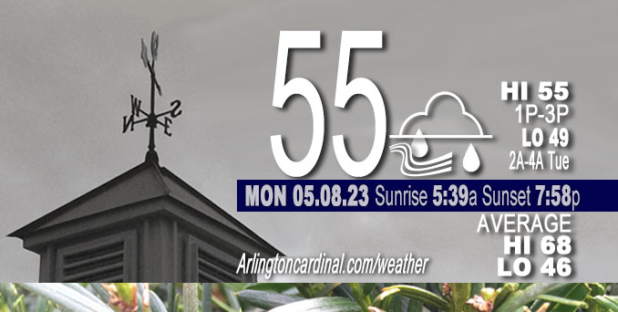
Monday Hi 55, chance rain until 3p, partly sunny to mostly cloudy, winds N to NE to N to NE, 5 to 18 to 10 MPH, G25 to 29 to 21 MPH, 3p to 6p
NWS CHGO | NWS HRLY | /NWSchicago | 🌡
ARLINGTON HEIGHTS WEATHER
▴ forecast7 (Arl. Hts.) | RADAR | WIDE RADAR
⏪ Hrly Data Table | Hrly Future Graph ⏩
IMPORTANT NOTE ON NWS DATA
⏪ Hrly Data Table | Hrly Future Graph ⏩
Hello mobile users! If you encounter a mobile “unfriendly” weather page, turn your phone sideways for a better view.
======================
Monday and Monday Evening …
Weather Hazards expected …
pending
DISCUSSION…
pending
======================
O’HARE FORECAST …
Forecast Beginning Monday, May 08, 2023
Monday: Scattered showers and thunderstorms. Cloudy, with a high near 66. East northeast wind around 10 mph. Chance of precipitation is 50%.
Monday night: Patchy fog after 5am. Otherwise, cloudy, then gradually becoming partly cloudy, with a low around 48. North northeast wind 5 to 10 mph, with gusts as high as 20 mph.
Tuesday: Patchy fog before 9am. Otherwise, mostly cloudy, then gradually becoming sunny, with a high near 65. North wind 5 to 10 mph.
Tuesday Night: Mostly clear, with a low around 48. Northeast wind 5 to 10 mph becoming light east northeast after midnight.
Wednesday: Sunny, with a high near 74. Calm wind becoming east southeast around 5 mph in the afternoon.
Wednesday Night: Partly cloudy, with a low around 53. East wind around 5 mph becoming calm after midnight. Winds could gust as high as 10 mph.
Thursday: Mostly sunny, with a high near 78.
Thursday Night: A 30 percent chance of showers after 2am. Mostly cloudy, with a low around 61.
Friday: A chance of showers, then showers likely and possibly a thunderstorm after 2pm. Mostly cloudy, with a high near 76.
Friday Night: Showers likely and possibly a thunderstorm. Mostly cloudy, with a low around 59.
Saturday: Showers likely, mainly before 8am. Mostly cloudy, with a high near 75.
Saturday Night: A chance of showers and thunderstorms. Mostly cloudy, with a low around 57.
Sunday: A chance of showers. Mostly cloudy, with a high near 67.
Sunday Night: A chance of showers. Mostly cloudy, with a low around 49.
Monday: Mostly sunny, with a high near 71.
* This forecast was reconstructed from 8 May 2023 10:51 PM and May 7’s forecast


CHICAGOWEATHERSTATION.COM

ChicagoWeatherStation.com I O’Hare Normal Temps/Precip I O’Hare Record Temps, Precip, Snow
WunderMap® with Temperature/Wind Data || Google: Arlington Heights Area Temps | US TEMPS
Midwest Cloud Cover with Arlington Heights Weather Forecast
ChicagoWeatherStation.com I O’Hare Normal Temps/Precip I O’Hare Record Temps, Precip, Snow
SUNLIGHT DATA FOR SECURITY, TRAFFIC SAFETY, AND SPORTS
SunCalc.net data with solar azimuth and trajectory, times for dawn, sunrise, solar noon, sunset, dusk …
NIGHT SKY THIS MONTH …
Backyard stargazers get a monthly guide to the northern hemisphere’s skywatching events with “Tonight’s Sky.” Check the night sky objects for this month and past months in the playlist from the Space Telescope Science Institute YouTube channel (Musical track The Far River written by Jonn Serrie, from the album And the Stars Go With You courtesy of New World Music Ltd).
Get updates from The Cardinal ALL NEWS FEEDS on Facebook. Just ‘LIKE’ the ‘Arlington Cardinal Page (become a fan of our page). The updates cover all posts and sub-category posts from The Cardinal — Arlingtoncardinal.com. You can also limit feeds to specific categories. See all of The Cardinal Facebook fan pages at Arlingtoncardinal.com/about/facebook …
Help fund The Cardinal Arlingtoncardinal.com/sponsor
/////////////>
Area Forecast Discussion
National Weather Service Chicago/Romeoville, IL
627 AM CDT Mon May 8 2023
.SHORT TERM… Issued at 248 AM CDT Mon May 8 2023
Through Tuesday…
Looks like one more day of semi-active weather before things quiet down for a bit. A secondary MCS continues to progress east across the Mississippi River early this morning, although in a much- diminished state from earlier. Still seeing some occasional measured wind gusts near 40 mph with the arrival of the cold pool, and suspect we`ll see similar gusts, at least sporadically, across locales well south of I-80 later this morning. Potentially starting to see signs of a second wake low developing on the favored northwestern flanks of the trailing stratiform precipitation shield across far northwest Missouri/southwest Iowa with 4-5 mb/2 hour pressure falls with the HRRR/RAP suggesting this feature may persist into the southwestern corner of the CWA later this morning. Will continue to keep an eye on this, although this one doesn`t seem like it`ll be as robust as what went through our area last evening.
Looks like a raw/unpleasant day near the lake with onshore flow and showers and possible patchy marine fog drifting inland. Have boosted PoPs roughly along and north of I-88 through much of the day to account for additional shower activity. Can`t rule out a stray lightning strike, although the main reservoir of instability looks to set up farther south.
It remains a bit unclear how things will evolve this afternoon. Would think that for much of the morning we`re socked in with low clouds/showers/etc. pretty much everywhere. However, some degree of early-mid afternoon clearing is certainly possible south of I-80, and most guidance now appears to be gradually eroding MLCIN during this time as temperatures warm into the mid to possibly upper 70s. With dewpoints in the mid 60s, MLCAPE is forecast to increase to around 1000 J/kg, it seems possible that isolated to scattered thunderstorms may develop late this afternoon as an upper vort max/shortwave/MCV remnant wobbles overhead. Surface convergence isn`t looking terribly strong, but felt it was prudent to carry chance PoPs to account for possible afternoon convection. Shear would be sufficient to support a few organized storms (and a marginal attendant severe threat), with instability looking like the main sticking point.
Activity should begin pushing south and east of the area this evening. Forecast soundings look supportive of precipitation ending as a little drizzle across northern Illinois/near the lake, but think we`ll end up precip-free everywhere overnight. If we clear out completely, fog would be possible into Tuesday morning, but don`t currently have that advertised in the gridded forecast.
Carlaw/NWS Chicago
