
Tuesday Hi 69, partly cloudy to mostly cloudy, winds N to NE to E, 3 to 9 to 3 MPH, G18 MPH, 9a to 10a
NWS CHGO | NWS HRLY | /NWSchicago | 🌡
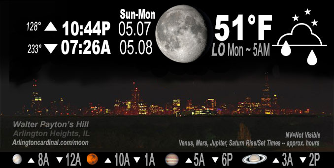
ARLINGTON HEIGHTS WEATHER
▴ forecast7 (Arl. Hts.) | RADAR | WIDE RADAR
IMPORTANT NOTE ON NWS DATA
Hello mobile users! If you encounter a mobile “unfriendly” weather page, turn your phone sideways for a better view.
======================
NIGHT FORECASTS …
NOTE: Keep in mind lunar rise and set times don’t always correspond with night weather and early morning lows because on some days during the month the moon is visible in the sky predominantly during the daytime hours.
Overnight Sunday to Monday …
No Weather Hazards expected …
pending
DISCUSSION…
pending
======================
O’HARE FORECAST …
Forecast Beginning Sunday Night, May 07, 2023 …
Sunday Night: Showers and thunderstorms likely, mainly after 1am. Some of the storms could produce heavy rainfall. Increasing clouds, with a low around 54. East wind 5 to 10 mph. Chance of precipitation is 60%. New rainfall amounts between a half and three quarters of an inch possible.
Monday: Showers likely and possibly a thunderstorm. Mostly cloudy, with a high near 68. East northeast wind around 10 mph. Chance of precipitation is 70%.
Monday Night: A chance of showers and thunderstorms. Mostly cloudy, with a low around 53. North northeast wind 5 to 10 mph. Chance of precipitation is 50%.
Tuesday: Partly sunny, with a high near 68.
Tuesday Night: Partly cloudy, with a low around 49.
Wednesday: Sunny, with a high near 71.
Wednesday Night: Partly cloudy, with a low around 52.
Thursday: Mostly sunny, with a high near 75.
Thursday Night: Mostly cloudy, with a low around 57.
Friday: A chance of showers. Mostly cloudy, with a high near 77.
Friday Night: A chance of showers. Mostly cloudy, with a low around 59.
Saturday: A chance of showers. Partly sunny, with a high near 79.
*Forecast used from Saturday night May 6, 2023
O’Hare forecast archive and hourly weather observations archive are available HERE on the CARDINAL NEWS Magazine.
Arlingtoncardinal.com/moonphases
Arlingtoncardinal.com/nightsky
NIGHT SKY THIS MONTH …
Check the night sky objects for this month and past months in the playlist from the Space Telescope Science Institute YouTube channel Backyard stargazers get a monthly guide to the northern hemisphere’s skywatching events with “Tonight’s Sky” (Musical track The Far River written by Jonn Serrie, from the album And the Stars Go With You courtesy of New World Music Ltd. Musical track The Far River written by Jonn Serrie, from the album And the Stars Go With You courtesy of New World Music Ltd).
Telephoto lens, ISO 100, f/11, Shutter Speed 1/100 to 1/125 for the Moon.
Get updates from The Cardinal ALL NEWS FEEDS on Facebook. Just ‘LIKE’ the ‘Arlington Cardinal Page (become a fan of our page). The updates cover all posts and sub-category posts from The Cardinal — Arlingtoncardinal.com. You can also limit feeds to specific categories. See all of The Cardinal Facebook fan pages at Arlingtoncardinal.com/about/facebook …
Help fund The Cardinal Arlingtoncardinal.com/sponsor
Telephoto lens, ISO 1600, f/11, Shutter Speed 2.5″ for the skyline. The skyline exposure was toned down, and brightness and contrast was adjusted in Photoshop.
/////////////>
Area Forecast Discussion
National Weather Service Chicago/Romeoville, IL
231 AM CDT Mon May 8 2023
.MESOSCALE DISCUSSION… Issued at 617 PM CDT Sun May 7 2023
Tricky forecast this evening. Lake breeze is catching up with the synoptic front from east to west, with synoptic boundary slowing or stalling the southward progress of the lake breeze front. Farther south, there is a convectively induced baroclinic zone that really is throwing in wrench in things and leading to a high degree of uncertainty in the evolution of convection this evening. Between the synoptic (soon to be combined with lake breeze) boundary near I-80 and convective outflow boundary downstate, the airmass is very unstable. Between these two boundaries, low level moisture hasn`t mixed out as much and instability quite strong, with SPC mesoanalysis suggesting >3000 j/kg of MLCAPE.
Broken line of supercells over eastern IA seems to be showing signs of cold cools amalgamating into a more cohesive singular cold pool, which would favor a forward propogating MCS developing. The intense HP supercell west of the Quad Cities could morph into the MCV with a developing MCS. It isn`t clear if this developing MCS/potential bow echo would track more east along the synoptic/lake breeze front or more southeast east near the convective baroclinic zone. Given recent radar trends and the strongly unstable air mass between the two boundaries, with southeasterly winds in this area strengthening storm relative inflow, believe the threat of a severe thunderstorms with damaging winds is increasing this evening south of I-80.
Will also need to watch for convection lighting up on the synoptic boundary ahead of the developing MCV for a potential hail threat, but bigger concern may be for training convection and flash flood threat with these storms.
Confidence in the above scenario is still low, but am growing a bit more concerned given observational trends over the past hour.
– Izzi/NWS Chicago
