
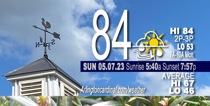
Sunday Hi 84, chance storm after 8p, likely after 11p, partly sunny to partly cloudy, winds W to NW to NE, 8 to 9 to 8 MPH, G13 to 14 MPH
NWS CHGO | NWS HRLY | /NWSchicago | 🌡
ARLINGTON HEIGHTS WEATHER
▴ forecast7 (Arl. Hts.) | RADAR | WIDE RADAR
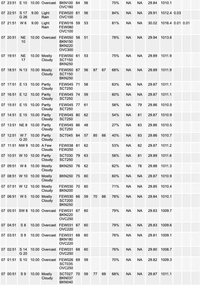
⏪ Hrly Data Table | Hrly Future Graph ⏩
IMPORTANT NOTE ON NWS DATA
⏪ Hrly Data Table | Hrly Future Graph ⏩
Hello mobile users! If you encounter a mobile “unfriendly” weather page, turn your phone sideways for a better view.
======================
Sunday and Sunday Evening …
Weather Hazards expected …
Elevated Thunderstorm Risk
Limited Hail Risk…up to half dollar size.
Elevated Damaging Wind Risk…up to 65 mph.
Limited Flooding Risk.
Limited Fog Risk.
DISCUSSION…
Scattered thunderstorms are expected to develop across Iowa this afternoon and track eastward into north-central Illinois this evening and overnight. The strongest storms will be capable of producing damaging winds and hail, with the highest coverage expected south of I-80. Storms will also produce heavy rainfall which could lead to flash flooding if storms train over the same area.
======================
O’HARE FORECAST …
Forecast Beginning Sunday, May 07, 2023
Sunday: Isolated showers and thunderstorms after 5pm. Mostly sunny, with a high near 84. West wind 5 to 10 mph becoming northeast in the afternoon. Chance of precipitation is 10%.
Sunday Night: Showers and thunderstorms likely, mainly after 11pm. Increasing clouds, with a low around 53. East northeast wind around 10 mph. Chance of precipitation is 70%. New rainfall amounts between a quarter and half of an inch possible.
Monday: Scattered showers and thunderstorms. Cloudy, with a high near 66. East northeast wind around 10 mph. Chance of precipitation is 50%.
Monday Night: A chance of showers and thunderstorms before 4am, then a slight chance of showers. Mostly cloudy, with a low around 50. North northeast wind 10 to 15 mph, with gusts as high as 20 mph. Chance of precipitation is 40%.
Tuesday: Partly sunny, with a high near 66. North northeast wind 5 to 10 mph, with gusts as high as 15 mph.
Tuesday Night: Partly cloudy, with a low around 48.
Wednesday: Sunny, with a high near 71.
Wednesday Night: Partly cloudy, with a low around 52.
Thursday: Mostly sunny, with a high near 75.
Thursday Night: Partly cloudy, with a low around 56.
Friday: A chance of showers. Partly sunny, with a high near 76.
Friday Night: A chance of showers. Mostly cloudy, with a low around 58.
Saturday: A chance of showers. Partly sunny, with a high near 75.


CHICAGOWEATHERSTATION.COM

ChicagoWeatherStation.com I O’Hare Normal Temps/Precip I O’Hare Record Temps, Precip, Snow
WunderMap® with Temperature/Wind Data || Google: Arlington Heights Area Temps | US TEMPS
Midwest Cloud Cover with Arlington Heights Weather Forecast
ChicagoWeatherStation.com I O’Hare Normal Temps/Precip I O’Hare Record Temps, Precip, Snow
SUNLIGHT DATA FOR SECURITY, TRAFFIC SAFETY, AND SPORTS
SunCalc.net data with solar azimuth and trajectory, times for dawn, sunrise, solar noon, sunset, dusk …
NIGHT SKY THIS MONTH …
Backyard stargazers get a monthly guide to the northern hemisphere’s skywatching events with “Tonight’s Sky.” Check the night sky objects for this month and past months in the playlist from the Space Telescope Science Institute YouTube channel (Musical track The Far River written by Jonn Serrie, from the album And the Stars Go With You courtesy of New World Music Ltd).
Get updates from The Cardinal ALL NEWS FEEDS on Facebook. Just ‘LIKE’ the ‘Arlington Cardinal Page (become a fan of our page). The updates cover all posts and sub-category posts from The Cardinal — Arlingtoncardinal.com. You can also limit feeds to specific categories. See all of The Cardinal Facebook fan pages at Arlingtoncardinal.com/about/facebook …
Help fund The Cardinal Arlingtoncardinal.com/sponsor
/////////////>
Area Forecast Discussion
National Weather Service Chicago/Romeoville, IL
632 AM CDT Sun May 7 2023
.SHORT TERM… Issued at 340 AM CDT Sun May 7 2023
Through Monday…
The ongoing clusters of thunderstorms across central Illinois are expected to continue to track eastward through daybreak. As they do so their resultant outflow is expected to stall across the region which will act as the primary guiding force for additional storms this afternoon and tonight. In the meantime, conditions will quickly improve this morning behind the storms with skies becoming mostly to partly sunny and temperatures warming into the low to mid-80s areawide. However, a strong “pneumonia” front is expected to dive south across Lake Michigan this afternoon which will lead to a rapid drop in temperatures for areas along the lake shore and adjacent inland areas and allow for the development of fog along the shoreline.
At the same time, a shortwave disturbance will be ejecting northeastward across the central Plains and interact with an abundance of instability over eastern Nebraska, Iowa, and northern Missouri. This will allow for the development of a cluster of thunderstorms across Iowa this afternoon that will traverse east- southeasterly along the aforementioned stalled outflow boundary through the evening and overnight hours. However, there continues to be a good deal of uncertainty as to where this boundary would be when storms fire which will determine how much of our area gets impacted. The latest guidance trends have been favoring a more southern position which would keep the bulk of the activity south of I-80, but obviously we will have to keep an eye on trends this morning before knowing for certain. Regardless, plentiful instability (nearly 3000 J/kg of CAPE and steep lapse rates around 8 C/km) and 40 kts of deep layer shear will allow these storms to organize and contain a threat for large hail and damaging wind gusts. Additionally, the moisture rich airmass (PWATs upwards of 1.5+ inches) may also lead to a threat of flash flooding if storms train over the same area for extended periods of time, particularly if a northwest-southeast storm orientation develops.
Furthermore, another round of storms may be possible on Monday if the aforementioned outflow boundary is not pushed southward from storms tonight. While instability does look to be a tad weaker on Monday, conditions still look to be supportive enough to get strong to severe storms and heavy rainfall. At this time guidance still shows at least the southern portions of our area under the gun, but there have been some notable southward shifts in recent runs which may keep the storms south of our area all together. Given this potential I have maintained a broad chance POP across the entire CWA for now, but we should be able to refine these details with later forecasts as trends solidify.
Yack/NWS Chicago
