
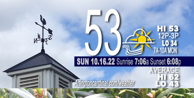
SUNDAY Hi 53°F, partly cloudy, increasing clouds, chance sparse sprinkles, winds W to SW, 9 to 7 to 14 MPH, G14 to 28 to 23 MPH
NWS CHGO | NWS HRLY | /NWSchicago | 🌡
ARLINGTON HEIGHTS WEATHER
▴ forecast7 (Arl. Hts.) | RADAR | WIDE RADAR
⏪ Hrly Data Table | Hrly Future Graph ⏩
IMPORTANT NOTE ON NWS DATA
⏪ Hrly Data Table | Hrly Future Graph ⏩
======================
No watches or warnings issued near O’Hare at 06:00 a.m.
Updates at Arlingtoncardinal.com/NWSChicago
Weather hazards expected…
Limited Freeze Risk. Temperatures are expected to fall into the lower 30s across interior portions of Illinois late Sunday night. Frost is not expected due to blustery conditions through the night.
Monday and Monday night, a strong fall storm system will bring possible snow showers and windy conditions to the area with northwest gusts to 35 mph area-wide and 40 to 45 mph along the Indiana shoreline.
Hello mobile users! If you encounter mobile “unfriendly” weather page, turn your phone sideways for a better view.
======================
O’HARE FORECAST …
Forecast Beginning Sunday, Oct. 16, 2022
Sunday: Increasing clouds, with a high near 53. West northwest wind 10 to 15 mph, with gusts as high as 25 mph.
Sunday Night: Mostly cloudy, with a low around 34. Northwest wind around 15 mph, with gusts as high as 25 mph.
Monday: A 20 percent chance of snow showers after 2pm. Mostly cloudy, with a high near 40. Breezy, with a northwest wind 15 to 25 mph, with gusts as high as 35 mph.
Monday Night: A 30 percent chance of snow showers before 2am. Mostly cloudy, with a low around 31. Blustery, with a northwest wind 15 to 20 mph, with gusts as high as 35 mph.
Tuesday: Mostly sunny, with a high near 47. Breezy, with a northwest wind 15 to 20 mph, with gusts as high as 30 mph.
Tuesday Night: Partly cloudy, with a low around 30.
Wednesday: Mostly sunny, with a high near 47.
Wednesday Night: Mostly cloudy, with a low around 35.
Thursday: Mostly sunny, with a high near 55.
Thursday Night: Mostly cloudy, with a low around 38.
Friday: Sunny, with a high near 63.
Friday Night: Partly cloudy, with a low around 46.
Saturday: Mostly sunny, with a high near 68.


CHICAGOWEATHERSTATION.COM

ChicagoWeatherStation.com I O’Hare Normal Temps/Precip I O’Hare Record Temps, Precip, Snow
LIVE RADAR | STORM TRACKS | UNISYS US IR SAT | UNISYS Midwest IR SAT | UNISYS More IR SAT
WunderMap® with Temperature/Wind Data || Google: Arlington Heights Area Temps | US TEMPS
Full Screen Motion Weather Radar (Wunderground.com)
Midwest Cloud Cover with Arlington Heights Weather Forecast
ChicagoWeatherStation.com I O’Hare Normal Temps/Precip I O’Hare Record Temps, Precip, Snow
SUNLIGHT DATA FOR SECURITY, TRAFFIC SAFETY, AND SPORTS
SunCalc.net data with solar azimuth and trajectory, times for dawn, sunrise, solar noon, sunset, dusk …
NIGHT SKY THIS MONTH …
Backyard stargazers get a monthly guide to the northern hemisphere’s skywatching events with “Tonight’s Sky.” Check the night sky objects for this month and past months in the playlist from the Space Telescope Science Institute YouTube channel (Musical track The Far River written by Jonn Serrie, from the album And the Stars Go With You courtesy of New World Music Ltd).
Get updates from The Cardinal ALL NEWS FEEDS on Facebook. Just ‘LIKE’ the ‘Arlington Cardinal Page (become a fan of our page). The updates cover all posts and sub-category posts from The Cardinal — Arlingtoncardinal.com. You can also limit feeds to specific categories. See all of The Cardinal Facebook fan pages at Arlingtoncardinal.com/about/facebook …
Help fund The Cardinal Arlingtoncardinal.com/sponsor
Area Forecast Discussion
National Weather Service Chicago/Romeoville, IL
619 AM CDT Sun Oct 16 2022
.SHORT TERM…
Issued at 317 AM CDT Sun Oct 16 2022
Through Sunday Night …
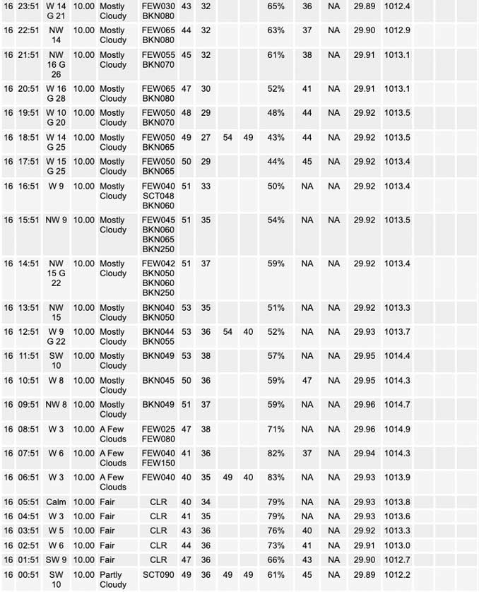
A dry cold front passage is underway early this morning, with the front aligned roughly from Mendota to Batavia to Winnetka as of 3am. The front will clear the CWA by around daybreak with little fanfare. Blustery WNW winds gusting 25mph+ are expected this afternoon as CAA commences under initially mostly sunny skies. Diurnal heating combined with steepening low-level lapse rates and a lifting inversion will support the development of a robust stratocumulus deck from north to south through the afternoon. Cloud depths should become sufficiently deep to generate some sparse sprinkles across far northeast Illinois late afternoon, though better precip chances will remain well northeast of the area.
Strong Cold Air Advection (CAA) will take hold late this afternoon through tonight, during which 850/700 hPa temps will drop as much as 10/15C. NW winds will continue to gust to 25 mph through the night, and possibly to 30mph by daybreak Monday. With the loss of daytime heating and drier upstream profiles, the forecast area should remain precip free tonight with the exception for a few lake effect showers clipping extreme northeast Porter County. Persistent stratus and gusty winds will limit radiational cooling, with a vast majority of cooling occurring from advection. Temps will fall into the low 30s for much of the interior CWA for a few hours late tonight. Given the marginal freeze conditions, no expected frost due to strong winds, and much colder conditions in the forecast for Monday night and Tuesday night, opted to hold off on a Freeze Warning.
Kluber/NWS Chicago
