
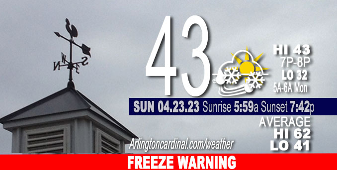
Sunday Hi 43, mostly cloudy to partly cloudy, scattered rain, snow showers, winds W to WNW to W, 7 to 9 to 5 MPH, G14 to 13 MPH 5p to 6p
NWS CHGO | NWS HRLY | /NWSchicago | 🌡
ARLINGTON HEIGHTS WEATHER
▴ forecast7 (Arl. Hts.) | RADAR | WIDE RADAR
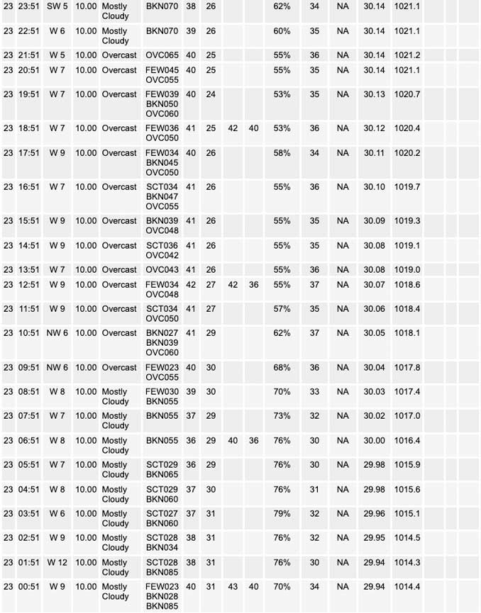
⏪ Hrly Data Table | Hrly Future Graph ⏩
IMPORTANT NOTE ON NWS DATA
⏪ Hrly Data Table | Hrly Future Graph ⏩
Hello mobile users! If you encounter a mobile “unfriendly” weather page, turn your phone sideways for a better view.
======================
Sunday and Sunday Evening …
Weather Hazards expected …
Significant Frost and Freeze Risk.
DISCUSSION…
Temperatures are expected to fall into the upper 20s to the low 30s late tonight for much of the area outside of the Chicago urban core.
Low 33 likely in southern Arlington Heights from 5:00 a.m. to 6:00 a.m.
Low 32 likely in northern Arlington Heights from 5:00 a.m. to 6:00 a.m.
======================
FREEZE WARNING …
Freeze Warning
URGENT – WEATHER MESSAGE
National Weather Service Chicago IL
313 PM CDT Sun Apr 23 2023
Winnebago-Boone-McHenry-Lake IL-Ogle-Lee-De Kalb-Kane-DuPage- La Salle-Kendall-Grundy-Kankakee-Livingston-Iroquois-Ford- Northern Cook-Southern Cook-Northern Will-Southern Will- Eastern Will-Lake IN-Porter-Newton-Jasper-Benton- Including the cities of Rockford, Belvidere, Crystal Lake, Algonquin, McHenry, Woodstock, Waukegan, Buffalo Grove, Mundelein, Gurnee, Rochelle, Oregon, Byron, Dixon, DeKalb, Sycamore, Aurora, Elgin, Naperville, Wheaton, Downers Grove, Lombard, Carol Stream, Ottawa, Streator, La Salle, Mendota, Marseilles, Oswego, Yorkville, Plano, Morris, Coal City, Minooka, Kankakee, Bourbonnais, Bradley, Pontiac, Dwight, Fairbury, Watseka, Gilman, Paxton, Gibson City, Evanston, Des Plaines, Schaumburg, Palatine, Northbrook, Calumet City, Oak Forest, Lemont, Orland Park, Park Forest, Joliet, Bolingbrook, Plainfield, Mokena, Channahon, Manhattan, Wilmington, Crete, Peotone, Beecher, Gary, Hammond, Merrillville, Portage, Valparaiso, Chesterton, Roselawn, Kentland, Morocco, Rensselaer, DeMotte, Fowler, and Oxford 313 PM CDT Sun Apr 23 2023 /413 PM EDT Sun Apr 23 2023/
…FREEZE WARNING REMAINS IN EFFECT FROM MIDNIGHT CDT /1 AM EDT/ SUNDAY/MONDAY OVERNIGHT TO 8 AM CDT /9 AM EDT/ MONDAY…
* WHAT…Freezing temperatures in the upper 20s to lower 30s expected.
* WHERE…Portions of central, east central, north central and northeast Illinois and northwest Indiana.
* WHEN…From midnight CDT /1 AM EDT/ tonight to 8 AM CDT /9 AM EDT/ Monday.
* IMPACTS…Frost and freeze conditions will kill crops and other sensitive vegetation.
PRECAUTIONARY/PREPAREDNESS ACTIONS…
Take steps now to protect tender plants from the cold such as covering them or bringing them indoors.
O’HARE FORECAST …
Forecast Beginning Sunday, Apr. 23, 2023
Sunday: A slight chance of rain and snow showers. Mostly cloudy, with a steady temperature around 42. West wind around 10 mph. Chance of precipitation is 20%.
Sunday Night: A chance of rain and snow showers, mainly before 7pm. Mostly cloudy, with a low around 33. West wind around 5 mph, with gusts as high as 10 mph. Chance of precipitation is 30%.
Monday: Mostly sunny, with a high near 52. West northwest wind 5 to 10 mph.
Monday Night: A 40 percent chance of showers, mainly after 1am. Mostly cloudy, with a low around 38. East wind around 5 mph becoming south southeast after midnight. Winds could gust as high as 10 mph.
Tuesday: A 40 percent chance of showers before 1pm. Mostly cloudy, with a high near 49. South southeast wind 5 to 10 mph becoming north northeast in the afternoon.
Tuesday Night: Patchy frost after 3am. Otherwise, mostly cloudy, with a low around 35.
Wednesday: Patchy frost before 7am. Otherwise, mostly sunny, with a high near 50.
Wednesday Night: Areas of frost after 1am. Otherwise, mostly clear, with a low around 35.
Thursday: Mostly sunny, with a high near 57.
Thursday Night: Mostly cloudy, with a low around 42.
Friday: A chance of showers. Partly sunny, with a high near 59.
Friday Night: A chance of showers. Mostly cloudy, with a low around 44.
Saturday: Showers likely. Mostly cloudy, with a high near 56.
Saturday Night: A chance of showers. Mostly cloudy, with a low around 43.
Sunday: Showers likely. Partly sunny, with a high near 55.


CHICAGOWEATHERSTATION.COM

ChicagoWeatherStation.com I O’Hare Normal Temps/Precip I O’Hare Record Temps, Precip, Snow
WunderMap® with Temperature/Wind Data || Google: Arlington Heights Area Temps | US TEMPS
Midwest Cloud Cover with Arlington Heights Weather Forecast
ChicagoWeatherStation.com I O’Hare Normal Temps/Precip I O’Hare Record Temps, Precip, Snow
SUNLIGHT DATA FOR SECURITY, TRAFFIC SAFETY, AND SPORTS
SunCalc.net data with solar azimuth and trajectory, times for dawn, sunrise, solar noon, sunset, dusk …
NIGHT SKY THIS MONTH …
Backyard stargazers get a monthly guide to the northern hemisphere’s skywatching events with “Tonight’s Sky.” Check the night sky objects for this month and past months in the playlist from the Space Telescope Science Institute YouTube channel (Musical track The Far River written by Jonn Serrie, from the album And the Stars Go With You courtesy of New World Music Ltd).
Get updates from The Cardinal ALL NEWS FEEDS on Facebook. Just ‘LIKE’ the ‘Arlington Cardinal Page (become a fan of our page). The updates cover all posts and sub-category posts from The Cardinal — Arlingtoncardinal.com. You can also limit feeds to specific categories. See all of The Cardinal Facebook fan pages at Arlingtoncardinal.com/about/facebook …
Help fund The Cardinal Arlingtoncardinal.com/sponsor
/////////////>
Area Forecast Discussion
National Weather Service Chicago/Romeoville, IL
618 AM CDT Sun Apr 23 2023
.SHORT TERM… Issued at 315 AM CDT Sun Apr 23 2023
Through Monday…
Forecast concerns for the short term forecast… *Widely scattered showers possible this afternoon into early evening
*Freeze Warning issued for widespread sub-freezing temperatures and frost tonight into Monday morning
The upper-low continues to spiral over the Great Lakes region which will lead to another cool and gloomy afternoon. A modest vort max is being analyzed across southern Minnesota and northern Iowa this morning and is expected to pivot overhead this afternoon. While moisture profiles are not nearly as impressive as observed on Saturday, forecast soundings are showing sufficient moisture in a roughly 3,000 ft deep layer that coincides with steep low-level lapse rates (around 7 C/km). These conditions should be sufficient to allow scattered showers to develop early this afternoon and persist into early evening before dissipating especially for eastern portions of the CWA. There is also the potential that a few of these showers could contain a rain-snow mix given the deep cold layer aloft, but most guidance suggests that the dendritic growth layer would be just above the better moisture which may keep the majority of the showers as rain especially with southward extent. However, I did maintain a rain- snow mention in the forecast to account for this potential but no snow accumulation is expected.
Otherwise mostly cloudy skies are expected for our Sunday with temperatures gradually warming into the mid-40s this afternoon. As the aforementioned vort max slides east this evening, drier air moving in aloft should thin out the cloud cover overnight. The combination of clearing skies, light west-northwesterly winds, and strong cold advection will allow temperatures to fall into the upper 20s and lower 30s across much of the area outside of downtown Chicago tonight. These conditions will allow for the development of widespread frost which could damage and/or kill sensitive plants. Therefore, the Freeze Watch was upgraded to a Freeze Warning from midnight tonight through 8 AM Monday morning to account for this threat so be sure to take measures to protect sensitive plants. Thankfully temperatures are expected to quickly rebound Monday afternoon with highs in the low to mid-50s, but a lake breeze will keep conditions slightly cooler for locations along the lake front.
Yack/NWS Chicago
