
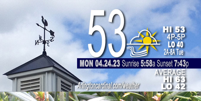
Monday Hi 53, partly sunny, winds W to NW to NE to SE, 8 to 11 to 6 MPH, G13 to 15 to 12 MPH 11p to 5p
NWS CHGO | NWS HRLY | /NWSchicago | 🌡
ARLINGTON HEIGHTS WEATHER
▴ forecast7 (Arl. Hts.) | RADAR | WIDE RADAR
⏪ Hrly Data Table | Hrly Future Graph ⏩
IMPORTANT NOTE ON NWS DATA
⏪ Hrly Data Table | Hrly Future Graph ⏩
Hello mobile users! If you encounter a mobile “unfriendly” weather page, turn your phone sideways for a better view.
======================
Monday and Monday Evening …
Weather Hazards expected …
Significant Frost and Freeze Risk end early morning (8AM).
DISCUSSION…
Temperatures were expected to fall into the upper 20s to the low 30s late tonight for much of the area outside of the Chicago urban core.
Sunday’s forecast and actual lows Monday, April 24, 2023 …
Low 33 likely in southern Arlington Heights from 5:00 a.m. to 6:00 a.m. The actual low was 36°F at 4:54 a.m. at the NWS office at O’Hare International Airport.
Low 32 likely in northern Arlington Heights from 5:00 a.m. to 6:00 a.m. The actual low was 36°F at 5:04 a.m. at the NWS office at Chicago Executive Airport.
======================
FREEZE WARNING …
Freeze Warning
URGENT – WEATHER MESSAGE
National Weather Service Chicago IL
313 PM CDT Sun Apr 23 2023
Winnebago-Boone-McHenry-Lake IL-Ogle-Lee-De Kalb-Kane-DuPage- La Salle-Kendall-Grundy-Kankakee-Livingston-Iroquois-Ford- Northern Cook-Southern Cook-Northern Will-Southern Will- Eastern Will-Lake IN-Porter-Newton-Jasper-Benton- Including the cities of Rockford, Belvidere, Crystal Lake, Algonquin, McHenry, Woodstock, Waukegan, Buffalo Grove, Mundelein, Gurnee, Rochelle, Oregon, Byron, Dixon, DeKalb, Sycamore, Aurora, Elgin, Naperville, Wheaton, Downers Grove, Lombard, Carol Stream, Ottawa, Streator, La Salle, Mendota, Marseilles, Oswego, Yorkville, Plano, Morris, Coal City, Minooka, Kankakee, Bourbonnais, Bradley, Pontiac, Dwight, Fairbury, Watseka, Gilman, Paxton, Gibson City, Evanston, Des Plaines, Schaumburg, Palatine, Northbrook, Calumet City, Oak Forest, Lemont, Orland Park, Park Forest, Joliet, Bolingbrook, Plainfield, Mokena, Channahon, Manhattan, Wilmington, Crete, Peotone, Beecher, Gary, Hammond, Merrillville, Portage, Valparaiso, Chesterton, Roselawn, Kentland, Morocco, Rensselaer, DeMotte, Fowler, and Oxford 313 PM CDT Sun Apr 23 2023 /413 PM EDT Sun Apr 23 2023/
…FREEZE WARNING REMAINS IN EFFECT FROM MIDNIGHT CDT /1 AM EDT/ SUNDAY/MONDAY OVERNIGHT TO 8 AM CDT /9 AM EDT/ MONDAY…
* WHAT…Freezing temperatures in the upper 20s to lower 30s expected.
* WHERE…Portions of central, east central, north central and northeast Illinois and northwest Indiana.
* WHEN…From midnight CDT /1 AM EDT/ tonight to 8 AM CDT /9 AM EDT/ Monday.
* IMPACTS…Frost and freeze conditions will kill crops and other sensitive vegetation.
PRECAUTIONARY/PREPAREDNESS ACTIONS…
Take steps now to protect tender plants from the cold such as covering them or bringing them indoors.
O’HARE FORECAST …
Forecast Beginning Monday, Apr. 24, 2023
Monday: Partly sunny, with a high near 53. Northwest wind around 10 mph, with gusts as high as 20 mph.
Monday Night: Showers likely, mainly after 3am. Mostly cloudy, with a low around 40. East wind 5 to 10 mph becoming south southwest after midnight. Chance of precipitation is 60%. New precipitation amounts of less than a tenth of an inch possible.
Tuesday: Showers likely, mainly before 11am. Mostly cloudy, with a high near 47. South southwest wind 5 to 10 mph becoming north northeast in the afternoon. Winds could gust as high as 15 mph. Chance of precipitation is 60%. New precipitation amounts of less than a tenth of an inch possible.
Tuesday Night: Areas of frost after 2am. Otherwise, mostly clear, with a low around 34. North northeast wind 5 to 10 mph, with gusts as high as 15 mph.
Wednesday: Patchy frost before 8am. Otherwise, sunny, with a high near 51. East northeast wind 5 to 10 mph.
Wednesday Night: Areas of frost after 2am. Otherwise, mostly clear, with a low around 36.
Thursday: Mostly sunny, with a high near 63.
Thursday Night: Mostly cloudy, with a low around 44.
Friday: A chance of showers after 1pm. Partly sunny, with a high near 63.
Friday Night: A chance of showers. Mostly cloudy, with a low around 45.
Saturday: Showers likely. Mostly cloudy, with a high near 59.
Saturday Night: A chance of showers. Mostly cloudy, with a low around 43.
Sunday: Showers likely. Mostly cloudy, with a high near 53.


CHICAGOWEATHERSTATION.COM

ChicagoWeatherStation.com I O’Hare Normal Temps/Precip I O’Hare Record Temps, Precip, Snow
WunderMap® with Temperature/Wind Data || Google: Arlington Heights Area Temps | US TEMPS
Midwest Cloud Cover with Arlington Heights Weather Forecast
ChicagoWeatherStation.com I O’Hare Normal Temps/Precip I O’Hare Record Temps, Precip, Snow
SUNLIGHT DATA FOR SECURITY, TRAFFIC SAFETY, AND SPORTS
SunCalc.net data with solar azimuth and trajectory, times for dawn, sunrise, solar noon, sunset, dusk …
NIGHT SKY THIS MONTH …
Backyard stargazers get a monthly guide to the northern hemisphere’s skywatching events with “Tonight’s Sky.” Check the night sky objects for this month and past months in the playlist from the Space Telescope Science Institute YouTube channel (Musical track The Far River written by Jonn Serrie, from the album And the Stars Go With You courtesy of New World Music Ltd).
Get updates from The Cardinal ALL NEWS FEEDS on Facebook. Just ‘LIKE’ the ‘Arlington Cardinal Page (become a fan of our page). The updates cover all posts and sub-category posts from The Cardinal — Arlingtoncardinal.com. You can also limit feeds to specific categories. See all of The Cardinal Facebook fan pages at Arlingtoncardinal.com/about/facebook …
Help fund The Cardinal Arlingtoncardinal.com/sponsor
/////////////>
Area Forecast Discussion
National Weather Service Chicago/Romeoville, IL
626 AM CDT Mon Apr 24 2023
.SHORT TERM… Issued at 332 AM CDT Mon Apr 24 2023
Through Tuesday…
Near term forecast highlights include freeze/frost conditions early this morning, then increasing rain chances across the area tonight and Tuesday. Temperatures will moderate a bit from those over the weekend, but will still be nearly 10 degrees below our averages for late April, and even cooler near Lake Michigan where winds will turn onshore this afternoon.
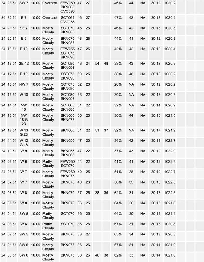
Deep upper level trough remains in place across Ontario and the Great Lakes region early this morning. Several embedded smaller scale vorts continue to transit the cyclonic flow about the main upper low, which was currently centered over far northern MN and the International border region. One of these vorts was noted in GOES vapor imagery over western WI, and will continue to track east- southeast across the region through sunrise this morning before shifting east of the forecast area. Main sensible weather associated with this feature is a patch of mid-level clouds (bases 7000-8000 feet) across northeast IL and Lake Michigan. While some patchy cloud cover may linger as the vort moves across the area early this morning, the trailing edge of the current more extensive deck should slide east of the area by sunrise. Unfortunately, this cloud deck blocked many locally from seeing the earlier Auroral display associated with a G4 geomagnetic storm. These clouds have also helped keep temps up a bit, though several sites west and south/southeast of the metro are currently reporting freezing temps in the low 30s/upper 20s as of 3 AM. Clearing over parts of the Chicago metro should allow for additional freezing temps with sunrise still a few hours away. Freeze warning thus continues for all except central Cook county through 8 AM CDT.
After some morning sunshine, diurnal stratocu will develop once again thanks to cool temps aloft associated with the lingering upper trough. Precip potential appears minimal however, thanks to drier low levels and a resulting shallower diurnal cloud deck. Clouds will gradually thicken across the western parts of the cwa this afternoon however, in response to developing warm/moist advection associated with a low-amplitude short wave moving out of the central Rockies this morning. The low level response to this feature will sharpen up the low level baroclinic zone which stretches from the Northern Plains to the mid Mississippi Valley, with frontogenetic forcing eventually helping saturate and force the development of rain from IA eastward into western IL by this evening. Rain will spread across much of the forecast area tonight as the wave continues east (and another vort wraps southeast around the upper low to our north), with locations along/south of the I-88 corridor most likely to see 0.15-0.20″ of rainfall overnight into Tuesday morning before tapering off from the northwest in the afternoon.
With the coldest temperatures aloft gradually shifting east today and modest low level warm advection developing, some moderation in temperatures is expected. Highs this afternoon should reach the mid 50s across our far west and southwest counties and the lower 50s elsewhere. The exception will be closer to Lake Michigan, where light winds associated with a weak surface high pressure ridge will allow for lake breeze development which will limit highs to the 40s closer to the lake. Temperatures will remain above freezing tonight with extensive cloud cover and showers. Surface winds turn north- northeast across much of the area Tuesday, as weak surface low pressure moves across central IL. Highs will again likely reach the low-mid 50s west and south, though a further inland push of lake- cooled air will limit temps to the 40s across far northeast IL and northwest IN.
Ratzer/NWS Chicago
