
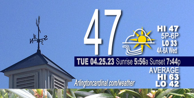
Tuesday Hi 47, partly sunny to partly cloudy, winds NE to NNE, 11 to 13 to 7 MPH, G16 to 14 MPH 5p to 8p
NWS CHGO | NWS HRLY | /NWSchicago | 🌡
ARLINGTON HEIGHTS WEATHER
▴ forecast7 (Arl. Hts.) | RADAR | WIDE RADAR
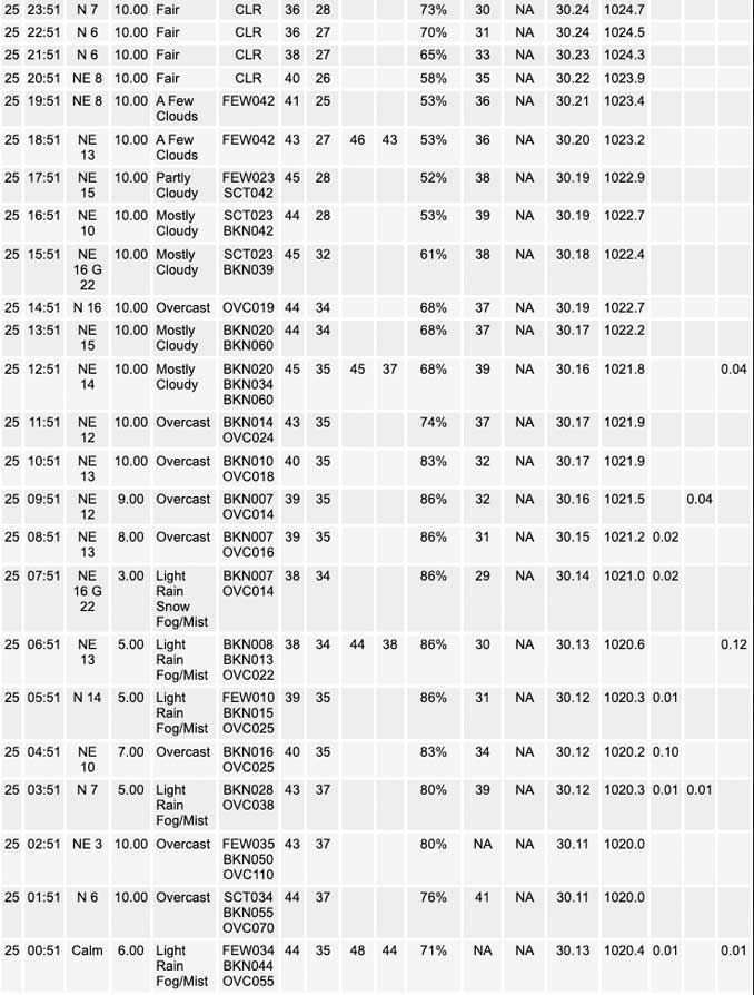
⏪ Hrly Data Table | Hrly Future Graph ⏩
IMPORTANT NOTE ON NWS DATA
⏪ Hrly Data Table | Hrly Future Graph ⏩
Hello mobile users! If you encounter a mobile “unfriendly” weather page, turn your phone sideways for a better view.
======================
Tuesday and Tuesday Evening …
Weather Hazards expected …
Significant Frost and Freeze Risk.
DISCUSSION…
Temperatures may drop below freezing late overnight Tuesday to Wednesday away from the core of the Chicago urban area and the immediate shore of Lake Michigan. Northwest and north central Illinois have the greatest chance of a freeze with temperatures in the upper 20s to around 30, though widespread frost is be possible elsewhere with temperatures in the lower 30s.
======================
O’HARE FORECAST …
Forecast Beginning Tuesday, Apr. 25, 2023
Tuesday: Showers likely, mainly after 3am. Cloudy, with a low around 41. South southeast wind around 5 mph, with gusts as high as 10 mph. Chance of precipitation is 70%. New precipitation amounts of less than a tenth of an inch possible.
Tuesday Night: Patchy frost after 2am. Otherwise, mostly clear, with a low around 33. North wind 5 to 10 mph, with gusts as high as 15 mph.
Wednesday: Areas of frost before 7am. Otherwise, sunny, with a high near 50. East northeast wind 5 to 10 mph.
Wednesday Night: Patchy frost after 4am. Otherwise, mostly clear, with a low around 37. Southeast wind around 5 mph.
Thursday: Patchy frost before 7am. Otherwise, sunny, with a high near 64. South wind 5 to 10 mph.
Thursday Night: A 20 percent chance of showers. Partly cloudy, with a low around 45. East southeast wind 5 to 10 mph.
Friday: Partly sunny, with a high near 60.
Friday Night: A 20 percent chance of showers. Mostly cloudy, with a low around 44.
Saturday: Showers likely, mainly after 1pm. Mostly cloudy, with a high near 62.
Saturday Night: Showers likely. Mostly cloudy, with a low around 42.
Sunday: Showers likely. Mostly cloudy, with a high near 53.
Sunday Night: A chance of showers. Mostly cloudy, with a low around 39.
Monday: A chance of showers. Mostly cloudy, with a high near 51.
Monday Night: Mostly cloudy, with a low around 40.
Tuesday: A chance of showers. Partly sunny, with a high near 55.


CHICAGOWEATHERSTATION.COM

ChicagoWeatherStation.com I O’Hare Normal Temps/Precip I O’Hare Record Temps, Precip, Snow
WunderMap® with Temperature/Wind Data || Google: Arlington Heights Area Temps | US TEMPS
Midwest Cloud Cover with Arlington Heights Weather Forecast
ChicagoWeatherStation.com I O’Hare Normal Temps/Precip I O’Hare Record Temps, Precip, Snow
SUNLIGHT DATA FOR SECURITY, TRAFFIC SAFETY, AND SPORTS
SunCalc.net data with solar azimuth and trajectory, times for dawn, sunrise, solar noon, sunset, dusk …
NIGHT SKY THIS MONTH …
Backyard stargazers get a monthly guide to the northern hemisphere’s skywatching events with “Tonight’s Sky.” Check the night sky objects for this month and past months in the playlist from the Space Telescope Science Institute YouTube channel (Musical track The Far River written by Jonn Serrie, from the album And the Stars Go With You courtesy of New World Music Ltd).
Get updates from The Cardinal ALL NEWS FEEDS on Facebook. Just ‘LIKE’ the ‘Arlington Cardinal Page (become a fan of our page). The updates cover all posts and sub-category posts from The Cardinal — Arlingtoncardinal.com. You can also limit feeds to specific categories. See all of The Cardinal Facebook fan pages at Arlingtoncardinal.com/about/facebook …
Help fund The Cardinal Arlingtoncardinal.com/sponsor
/////////////>
Area Forecast Discussion
National Weather Service Chicago/Romeoville, IL
623 AM CDT Tue Apr 25 2023
.SHORT TERM… Issued at 320 AM CDT Tue Apr 25 2023
Through Wednesday…
Short term forecast highlights include rain/showers this morning, clearing skies with frost/freeze potential tonight, and sunny but cool conditions Wednesday. A freeze watch remains in effect for late tonight for roughly the northwest half of the forecast area.
Early morning surface analysis depicts a weak low pressure wave near the Mississippi River borders of IA/MO/IL. This wave was tracking east along a west-east oriented frontal zone which extends east along the WFO LOT/ILX border region, in association with a low- amplitude mid-level short wave trough and additional larger scale ascent likely provided by another vort propagating across WI and Lake Michigan. Weak DCVA, warm/moist advection and resulting frontogenetic forcing has led to the development of showers across the forecast area since last evening. These showers will persist across the forecast area this morning, before weakening ascent and the intrusion of drier air from the west results in them weakening and shifting east and southeast of the area by early afternoon.
Modest mid-level height rises will develop across the upper Midwest later today in the wake of the aforementioned short wave features, with further rises into Wednesday as the pesky upper trough which has lingered across the Great Lakes region shifts east and short wave upper level ridging develops across the upper Mississippi Valley. This will be reflected at the surface by an area of high pressure which will settle across the western Great Lakes late tonight and Wednesday. Surface winds will turn northeast this afternoon as increasing subsidence and low level dry advection scatter out cloud cover, but despite some sunshine, onshore flow off of Lake Michigan will maintain cool temperatures especially near the shore where highs will only reach the mid-40s. Farther to the west and south temps should reach the mid-50s, still near ten degrees below average for late April.
Skies will clear and winds will diminish tonight as the surface high settles into the region. This will set up another chilly night with the potential for frost and freezing temperatures. With the center of the high over WI by morning, far north/northwest IL appear to have the best potential for light/calm winds and true freezing conditions, with lows in the upper 20s to around 30 expected. A freeze watch remains in effect for this area from midnight tonight through 8 am Wednesday morning. Slightly less confidence in areas farther southeast seeing a hard freeze (especially along the immediate Lake Michigan shore and in the core of the Chicago urban heat island), though a fairly widespread frost is likely for much of the area away from the lake and city. May potentially need a frost advisory or an expansion of freeze headlines for some of these other locations, though will allow day shift to further address cloud cover and wind trends for any additional headline needs for late tonight.
Surface high remains centered over the western Lakes Wednesday providing dry and sunny, but still cool conditions with onshore lake breezes. We should add a few degrees over today`s highs and reach the mid-upper 50s well inland, though lakeside locations will likely be limited to the 40s once again.
Ratzer/NWS Chicago
