
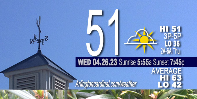
Wednesday Hi 51, mostly sunny, winds NE to E to ESE, 7 to 9 to 5 MPH
NWS CHGO | NWS HRLY | /NWSchicago | 🌡
ARLINGTON HEIGHTS WEATHER
▴ forecast7 (Arl. Hts.) | RADAR | WIDE RADAR
⏪ Hrly Data Table | Hrly Future Graph ⏩
IMPORTANT NOTE ON NWS DATA
⏪ Hrly Data Table | Hrly Future Graph ⏩
Hello mobile users! If you encounter a mobile “unfriendly” weather page, turn your phone sideways for a better view.
======================
Wednesday and Wednesday Evening …
Weather Hazards expected …
Elevated Frost and Freeze Risk late tonight.
DISCUSSION…
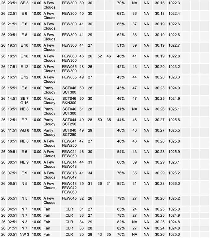
Temperatures are expected to drop into the lower and middle 30s tonight away from the heart of the Chicago urban area and the immediate Lake Michigan shore. Areas of frost are likely in these areas from late tonight through sunrise Thursday.
======================
O’HARE FORECAST …
Forecast Beginning Wednesday, Apr. 26, 2023
Wednesday: Sunny, with a high near 51. Northeast wind 5 to 10 mph.
Wednesday Night: Areas of frost after 1am. Otherwise, mostly clear, with a low around 36. East wind around 5 mph becoming south southeast after midnight.
Thursday: Mostly sunny, with a high near 65. South southeast wind 5 to 10 mph, with gusts as high as 15 mph.
Thursday Night: A 40 percent chance of showers, mainly after 1am. Mostly cloudy, with a low around 45. East wind 5 to 10 mph.
Friday: A 40 percent chance of showers. Partly sunny, with a high near 60. North northeast wind 5 to 10 mph, with gusts as high as 15 mph.
Friday Night: A 20 percent chance of showers after 1am. Mostly cloudy, with a low around 43.
Saturday: A 50 percent chance of showers. Partly sunny, with a high near 61.
Saturday Night: A chance of showers. Mostly cloudy, with a low around 41.
Sunday: A chance of showers. Mostly cloudy, with a high near 53.
Sunday Night: A chance of showers. Mostly cloudy, with a low around 39.
Monday: A chance of showers. Mostly cloudy, with a high near 52.
Monday Night: Mostly cloudy, with a low around 39.
Tuesday: Partly sunny, with a high near 56.


CHICAGOWEATHERSTATION.COM

ChicagoWeatherStation.com I O’Hare Normal Temps/Precip I O’Hare Record Temps, Precip, Snow
WunderMap® with Temperature/Wind Data || Google: Arlington Heights Area Temps | US TEMPS
Midwest Cloud Cover with Arlington Heights Weather Forecast
ChicagoWeatherStation.com I O’Hare Normal Temps/Precip I O’Hare Record Temps, Precip, Snow
SUNLIGHT DATA FOR SECURITY, TRAFFIC SAFETY, AND SPORTS
SunCalc.net data with solar azimuth and trajectory, times for dawn, sunrise, solar noon, sunset, dusk …
NIGHT SKY THIS MONTH …
Backyard stargazers get a monthly guide to the northern hemisphere’s skywatching events with “Tonight’s Sky.” Check the night sky objects for this month and past months in the playlist from the Space Telescope Science Institute YouTube channel (Musical track The Far River written by Jonn Serrie, from the album And the Stars Go With You courtesy of New World Music Ltd).
Get updates from The Cardinal ALL NEWS FEEDS on Facebook. Just ‘LIKE’ the ‘Arlington Cardinal Page (become a fan of our page). The updates cover all posts and sub-category posts from The Cardinal — Arlingtoncardinal.com. You can also limit feeds to specific categories. See all of The Cardinal Facebook fan pages at Arlingtoncardinal.com/about/facebook …
Help fund The Cardinal Arlingtoncardinal.com/sponsor
/////////////>
Area Forecast Discussion
National Weather Service Chicago/Romeoville, IL
619 AM CDT Thu Apr 27 2023
.SHORT TERM… Issued at 313 AM CDT Thu Apr 27 2023
Through Friday…
Short term forecast highlights include sunny and warmer weather today with a smaller lake-cooling footprint, then increasing clouds tonight with rain chances mainly southeast of I-55 later tonight into Friday. Temperatures remain will mild Friday outside of the thicker cloud cover and showers across the southeastern cwa, and away from Lake Michigan where onshore winds will kee Preadings cooler.
Surface high pressure ridging stretches from southern Quebec southwest across the Great Lakes and into northern Missouri per latest analysis. Light east-southeast winds, temperatures in the low to mid 30s (outside of Chicago) and some thin patchy high cirrus represent the resulting quiet early morning weather conditions. This quiet weather will continue today, as we remain within the western periphery of the surface high pressure ridge. Modest warm advection aloft will allow continued moderation of temperatures across the forecast area, while south-southeast surface winds will result in a smaller footprint of lake cooling which will be focused mainly across the north shore suburbs and the immediate lake shore elsewhere. 925 mb temperature climatology and forecast soundings support highs warming into the mid-upper 60s across the west/south parts of the cwa, while locations near Lake Michigan top out in the mid-50s. While thin high clouds will gradually increase later this afternoon from the south ahead of a short wave propagating from the Southern Plains, plenty of sun is expected.
Guidance has trended farther south with the track of the aforementioned southern Plains wave tonight into Saturday, and its associated surface low pressure center which is progged to track through the Ohio Valley late tonight into Friday. This more southern track focuses better moisture return and resulting precipitation across southern and central IL/IN during this period, with rain mainly glancing the southeastern cwa east/southeast of the I-55 (or even I-57) corridor. Thus the northwest half to two thirds of the forecast area look to remain dry through Friday and have significantly lowered pops. Far southeast cwa counties will likely see less than two tenths of an inch of rain, with greater amounts south and east of the forecast area. Showers linger especially Friday morning in the southeast, while dry weather with mostly cloudy skies are expected farther north and west.
Lows tonight will remain largely in the 40s, though a few spots near the IL/WI border may dip into the upper 30s where cloud cover will likely not be as thick. Western parts of the forecast area still look to reach the mid-upper 60s Friday afternoon, while northeast surface winds and thicker clouds in the southeast parts of the forecast area keep temps in the low 60s and areas near Lake Michigan in the 50s.
Ratzer/NWS Chicago
