
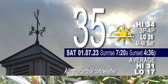
Saturday Hi 35, some clearing skies to partly sunny, winds NE to ENE, 5 to 2 MPH
NWS CHGO | NWS HRLY | /NWSchicago | 🌡
ARLINGTON HEIGHTS WEATHER
▴ forecast7 (Arl. Hts.) | RADAR | WIDE RADAR
⏪ Hrly Data Table | Hrly Future Graph ⏩
IMPORTANT NOTE ON NWS DATA
⏪ Hrly Data Table | Hrly Future Graph ⏩
======================
Saturday and Saturday Night …
No Weather Hazards expected…
Quiet day with light winds. We’ll see if there is another unrealized forecast of the sun appearing behind clouds as has happened the past few days. Saturday’s forecast calls for some breaks in the clouds after 12:00 p.m. The good news about clouds is that clouds prevent heat escape at night, and keep night time temperatures from falling to extreme lows.
DISCUSSION…
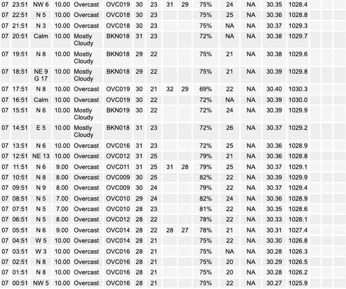
Early morning GOES water vapor imagery continues to depict an upper level trough from the Great Lakes across the Northeast and eastern Canada. An extensive area of low stratus was evident in IR imagery from the Great Lakes back into Wisconsin/Northern IL, spreading slowly south- southwest in response to low level north-northeast low level winds within the southeastern periphery of the surface high to our northwest.
An Aircraft Meteorological Data Relay (AMDAR) aircraft descent sounding into Chicago Midway International Airport KMDW around 0525Z showed this stratus layer to be relatively thin, trapped below a sharp inversion based around 1200 feet Above Ground Level (AGL). Model initializations appear to be having a tough time with this thin cloud layer, lending somewhat low confidence to forecast cloud cover trends across the area Saturday. Would expect east/northeast parts of the forecast area to have the toughest time eroding the stratus cloud layer, especially with continued advection from across the lake into Michigan. NWS expects mostly cloudy conditions for the Chicago area, while areas farther northwest and west may see some decrease in cloud cover.
The big good news regarding cloud cover is that clouds have helped to prevent night time temps from falling with excessively cold temperatures, which might help heating bills a little bit.
======================
O’HARE FORECAST …
Forecast Beginning Saturday, Jan. 07, 2023
Today: Cloudy, with a high near 35. Northeast wind around 5 mph.
Tonight: Mostly cloudy, with a low around 26. Northeast wind around 5 mph becoming calm in the evening.
Sunday: A chance of flurries between 7am and 1pm. Mostly cloudy, with a high near 36. Calm wind becoming west around 5 mph in the afternoon.
Sunday Night: Partly cloudy, with a low around 24. West southwest wind 5 to 10 mph.
Monday: Mostly sunny, with a high near 39. Southwest wind 5 to 10 mph, with gusts as high as 15 mph.
Monday Night: Mostly cloudy, with a low around 31.
Tuesday: Partly sunny, with a high near 42.
Tuesday Night: Mostly cloudy, with a low around 32.
Wednesday: Mostly cloudy, with a high near 42.
Wednesday Night: Mostly cloudy, with a low around 35.
Thursday: A chance of rain. Cloudy, with a high near 41.
Thursday Night: A chance of rain and snow. Cloudy, with a low around 32.
Friday: A chance of rain and snow. Mostly cloudy, with a high near 37.


CHICAGOWEATHERSTATION.COM

ChicagoWeatherStation.com I O’Hare Normal Temps/Precip I O’Hare Record Temps, Precip, Snow
LIVE RADAR | STORM TRACKS | UNISYS US IR SAT | UNISYS Midwest IR SAT | UNISYS More IR SAT
WunderMap® with Temperature/Wind Data || Google: Arlington Heights Area Temps | US TEMPS
Full Screen Motion Weather Radar (Wunderground.com)
Midwest Cloud Cover with Arlington Heights Weather Forecast
ChicagoWeatherStation.com I O’Hare Normal Temps/Precip I O’Hare Record Temps, Precip, Snow
SUNLIGHT DATA FOR SECURITY, TRAFFIC SAFETY, AND SPORTS
SunCalc.net data with solar azimuth and trajectory, times for dawn, sunrise, solar noon, sunset, dusk …
NIGHT SKY THIS MONTH …
Backyard stargazers get a monthly guide to the northern hemisphere’s skywatching events with “Tonight’s Sky.” Check the night sky objects for this month and past months in the playlist from the Space Telescope Science Institute YouTube channel (Musical track The Far River written by Jonn Serrie, from the album And the Stars Go With You courtesy of New World Music Ltd).
Get updates from The Cardinal ALL NEWS FEEDS on Facebook. Just ‘LIKE’ the ‘Arlington Cardinal Page (become a fan of our page). The updates cover all posts and sub-category posts from The Cardinal — Arlingtoncardinal.com. You can also limit feeds to specific categories. See all of The Cardinal Facebook fan pages at Arlingtoncardinal.com/about/facebook …
Help fund The Cardinal Arlingtoncardinal.com/sponsor
Area Forecast Discussion
National Weather Service Chicago/Romeoville, IL
533 AM CST Sat Jan 7 2023
.SHORT TERM… Issued at 311 AM CST Sat Jan 7 2023
Through Sunday…
Early morning GOES water vapor imagery continues to depict an upper level trough from the Great Lakes across the Northeast and eastern Canada. To our west, a mid-level short wave was propagating slowly east across eastern NE/KS. At the surface, high pressure extended from the eastern Dakotas into the upper MS valley and Ontario, while low pressure was evident across eastern OK in association with the NE/KS short wave and an attendant 120+ kt upper level jet streak. An extensive area of low stratus was evident in IR imagery from the Great Lakes back into WI/northern IL, spreading slowly south- southwest in response to low level north-northeast low level winds within the southeastern periphery of the surface high to our northwest. An AMDAR aircraft descent sounding into KMDW around 0525Z showed this stratus layer to be relatively thin, trapped below a sharp inversion based around 1200 feet AGL. Model initializations appear to be having a tough time with this thin cloud layer, lending somewhat low confidence to forecast cloud cover trends across the area today. Would expect east/northeast parts of the forecast area to have the toughest time eroding the stratus, especially with continued advection from across the lake into MI. Thus expecting mostly cloudy conditions for the Chicago area, while areas farther northwest and west may see some decrease in cloud cover. Clouds have helped to prevent temps from falling too much overnight, and highs today are expected to be largely in the mid-30s.
Attention then turns to the mid-level short wave/weak closed low advancing slowly east into IA by this evening, and eventually drifting across the forecast area on Sunday. The best low level mass response and moisture advection associated with this disturbance continues to be focused south of the cwa across the lower MO/OH valleys and central/southern parts of IL and IN. Weaker forcing does eventually develop into northern IL/IN later tonight into Sunday, though with little in the way of deeper moisture advection into the forecast area. Lack of strong jet forcing and only modest isentropic ascent appear rather unimpressive given dry low levels noted in forecast sounding profiles, though soundings do depict fairly steep mid-level lapse rates aloft (7-7.5 C/km in the 700-500 mb layer). Given this, have maintained chance pops late tonight through Sunday morning mainly south of the I-80 corridor form the potential for some minor accumulations (a dusting to less than an inch), and included a chance of flurries as far north as about I-88 across northern IL where drier low levels should prevent any measurable snow threat. Precip chances will diminish from west to east after midday Sunday as the upper trough axis moves slowly east. Not completely out of the question that some patchy drizzle/freezing drizzle could develop within the low-level stratus layer north of the better snow chances early Sunday, though the moist layer may likely be too shallow for that to materialize. Daytime temps are expected to rise above freezing again Sunday, with highs again in the mid-30s.
Ratzer/NWS Chicago
