
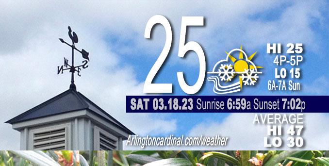
Saturday Hi 25, partly sunny to partly cloudy, winds WNW, 20 to 21 to 15 MPH, G29 to 30 to 24 MPH diminishing Sunday
NWS CHGO | NWS HRLY | /NWSchicago | 🌡
ARLINGTON HEIGHTS WEATHER
▴ forecast7 (Arl. Hts.) | RADAR | WIDE RADAR
⏪ Hrly Data Table | Hrly Future Graph ⏩
IMPORTANT NOTE ON NWS DATA
⏪ Hrly Data Table | Hrly Future Graph ⏩
Hello mobile users! If you encounter a mobile “unfriendly” weather page, turn your phone sideways for a better view.
======================
Saturday and Saturday Evening …
Weather Hazards expected …
Limited Excessive Cold Risk Saturday morning.
Limited Snow Risk Saturday afternoon.
DISCUSSION…
Scattered flurries and snow showers are expected through this afternoon. While most places will see little to no accumulation, locations under more robust showers could see quick accumulations upwards of a half to one inch in addition to sharp reductions in visibility leading to hazardous travel conditions.
Wind chills this morning will be at or below zero before warming into the low teens this afternoon.
======================
O’HARE FORECAST …
Forecast Beginning Saturday, Mar. 18, 2023
Saturday: Scattered snow showers, mainly between 3pm and 5pm. Mostly cloudy, with a high near 25. Blustery, with a west northwest wind around 20 mph, with gusts as high as 30 mph. Chance of precipitation is 30%.
Saturday Night: Scattered flurries with isolated snow showers before 7pm, then scattered flurries between 7pm and 9pm. Mostly cloudy, then gradually becoming mostly clear, with a low around 18. West northwest wind 10 to 15 mph, with gusts as high as 25 mph. Chance of precipitation is 10%.
Sunday: Sunny, with a high near 40. West southwest wind 10 to 15 mph, with gusts as high as 20 mph.
Sunday Night: Mostly clear, with a low around 28. Southwest wind around 15 mph, with gusts as high as 25 mph.
Monday: Partly sunny, with a high near 50. Breezy, with a southwest wind 15 to 20 mph, with gusts as high as 30 mph.
Monday Night: Mostly cloudy, with a low around 37.
Tuesday: A 20 percent chance of rain after 1pm. Mostly cloudy, with a high near 52.
Tuesday Night: Rain likely. Mostly cloudy, with a low around 41.
Wednesday: Rain likely. Mostly cloudy, with a high near 55.
Wednesday Night: Rain likely, mainly after 1am. Mostly cloudy, with a low around 43.
Thursday: Rain likely. Mostly cloudy, with a high near 54.
Thursday Night: Rain likely. Mostly cloudy, with a low around 41.
Friday: A chance of rain. Mostly cloudy, with a high near 51.


CHICAGOWEATHERSTATION.COM

ChicagoWeatherStation.com I O’Hare Normal Temps/Precip I O’Hare Record Temps, Precip, Snow
LIVE RADAR | STORM TRACKS | UNISYS US IR SAT | UNISYS Midwest IR SAT | UNISYS More IR SAT
WunderMap® with Temperature/Wind Data || Google: Arlington Heights Area Temps | US TEMPS
Full Screen Motion Weather Radar (Wunderground.com)
Midwest Cloud Cover with Arlington Heights Weather Forecast
ChicagoWeatherStation.com I O’Hare Normal Temps/Precip I O’Hare Record Temps, Precip, Snow
SUNLIGHT DATA FOR SECURITY, TRAFFIC SAFETY, AND SPORTS
SunCalc.net data with solar azimuth and trajectory, times for dawn, sunrise, solar noon, sunset, dusk …
NIGHT SKY THIS MONTH …
Backyard stargazers get a monthly guide to the northern hemisphere’s skywatching events with “Tonight’s Sky.” Check the night sky objects for this month and past months in the playlist from the Space Telescope Science Institute YouTube channel (Musical track The Far River written by Jonn Serrie, from the album And the Stars Go With You courtesy of New World Music Ltd).
Get updates from The Cardinal ALL NEWS FEEDS on Facebook. Just ‘LIKE’ the ‘Arlington Cardinal Page (become a fan of our page). The updates cover all posts and sub-category posts from The Cardinal — Arlingtoncardinal.com. You can also limit feeds to specific categories. See all of The Cardinal Facebook fan pages at Arlingtoncardinal.com/about/facebook …
Help fund The Cardinal Arlingtoncardinal.com/sponsor
/////////////>
Area Forecast Discussion
National Weather Service Chicago/Romeoville, IL
624 AM CDT Sat Mar 18 2023
.SHORT TERM… Issued at 341 AM CDT Sat Mar 18 2023
Through Sunday…
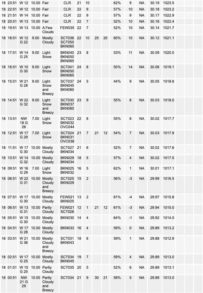
Snow showers continue to move across portions of northeastern Illinois and northwest Indiana this morning which is leading to brief reductions in visibility and a light coating of snow on surfaces. While these showers will move east of the area by daybreak, the cold arctic air mass and broad synoptic ascent generated by the large shortwave trough over the Great Lakes will allow scattered flurries to linger through much of our Saturday.
Guidance has continued to indicate that a few snow showers would develo Pthis afternoon as a vort max dives through the area. While forecast soundings continue to show marginal moisture in place, the cold air mass looks to keep the DGZ around 850 mb where it should be able to take advantage of sufficient moisture. Additionally, the combination of the synoptic ascent generated by the vort max and steep low-level lapse rates (around 7 to 8 C/km) through the depth of the DGZ should further help to compensate for the marginal moisture and allow for some accumulation given the subfreezing surface temperatures. While most of the accumulation will be on the order of a dusting to a tenth of an inch, there is a non-zero chance that a more robust snow shower could lead to locally higher amounts around a half an inch or so if better moisture is realized. Given the expected convective nature of these showers there continues to be some uncertainty in the exact location these showers would impact, but since I wanted some accumulation mention in the forecast did decide to paint the area under a couple tenths of accumulation for this potential. However, there is a good chance that most areas may not accumulate much of anything.
Otherwise, blustery conditions are expected for today with abnormally cold temperatures as highs only reach the mid 20s this afternoon. The combination of these temperatures and northwest winds gusting around 30 mph will create wind chills in the single digits and low teens so be sure to bundle up before venturing out.
Thankfully this cold snap is expected to be brief as a surface high builds into the region on Sunday and allows temperatures to warm into the upper 30s to near 40 under sunny skies.
Yack/NWS Chicago
