
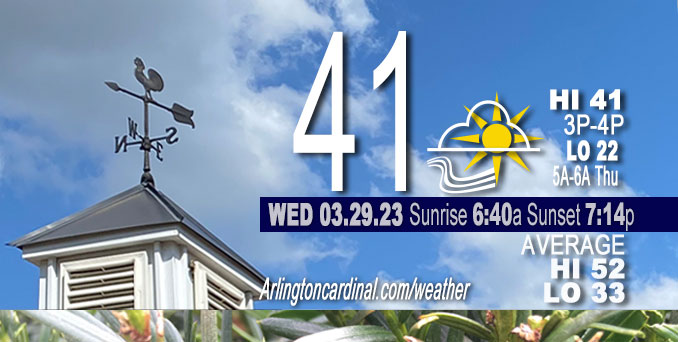
Wednesday Hi 41, mostly cloudy to partly cloudy, winds WNW to NW to NE to E, 13 to 15 to 2 MPH, G21 to 24 to 15 MPH, until 3p
NWS CHGO | NWS HRLY | /NWSchicago | 🌡
ARLINGTON HEIGHTS WEATHER
▴ forecast7 (Arl. Hts.) | RADAR | WIDE RADAR
⏪ Hrly Data Table | Hrly Future Graph ⏩
IMPORTANT NOTE ON NWS DATA
⏪ Hrly Data Table | Hrly Future Graph ⏩
Hello mobile users! If you encounter a mobile “unfriendly” weather page, turn your phone sideways for a better view.
======================
Wednesday and Wednesday Evening …
Weather Hazards expected …
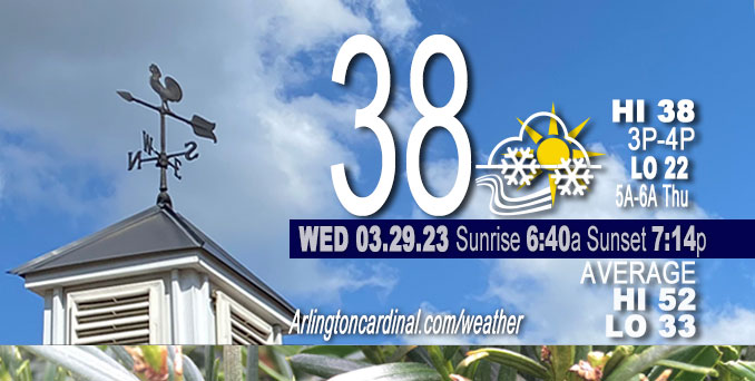
Limited morning Snow Risk.
DISCUSSION…
A quick burst of accumulating snow accompanied by gusty winds and brief visibility reductions is possible this morning across parts of northern Illinois and far northwestern Indiana.
======================
O’HARE FORECAST …
Forecast Beginning Wednesday, Mar. 29, 2023
Wednesday: Snow likely, mainly before 11am. Cloudy through mid morning, then gradual clearing, with a high near 39. West wind 10 to 15 mph becoming north northwest in the afternoon. Winds could gust as high as 25 mph. Chance of precipitation is 60%. Total daytime snow accumulation of less than a half inch possible.
Wednesday Night: Mostly clear, with a low around 24. North northeast wind around 5 mph becoming calm in the evening.
Thursday: A 20 percent chance of rain after 4pm. Mostly sunny, with a high near 53. South southeast wind 5 to 10 mph, with gusts as high as 20 mph.
Thursday Night: A chance of rain, then rain likely and possibly a thunderstorm after 1am. Mostly cloudy, with a low around 48. Breezy, with a south southwest wind 15 to 25 mph, with gusts as high as 35 mph. Chance of precipitation is 70%.
Friday: A chance of rain and thunderstorms, then rain and possibly a thunderstorm after 1pm. High near 64. Breezy, with a south southwest wind 20 to 25 mph, with gusts as high as 35 mph. Chance of precipitation is 90%.
Friday Night: Rain before 4am, then rain and snow likely. Some thunder is also possible. Low around 35. Breezy. Chance of precipitation is 90%.
Saturday: Snow likely, possibly mixed with rain, mainly before 7am. Partly sunny, with a high near 44. Breezy. Chance of precipitation is 60%.
Saturday Night: Mostly clear, with a low around 30.
Sunday: Mostly sunny, with a high near 58. Breezy.
Sunday Night: Partly cloudy, with a low around 46. Breezy.
Monday: Partly sunny, with a high near 60.
Monday Night: A chance of rain. Mostly cloudy, with a low around 44.
Tuesday: A chance of rain. Partly sunny, with a high near 64. Breezy.


CHICAGOWEATHERSTATION.COM

ChicagoWeatherStation.com I O’Hare Normal Temps/Precip I O’Hare Record Temps, Precip, Snow
LIVE RADAR | STORM TRACKS | UNISYS US IR SAT | UNISYS Midwest IR SAT | UNISYS More IR SAT
WunderMap® with Temperature/Wind Data || Google: Arlington Heights Area Temps | US TEMPS
Full Screen Motion Weather Radar (Wunderground.com)
Midwest Cloud Cover with Arlington Heights Weather Forecast
ChicagoWeatherStation.com I O’Hare Normal Temps/Precip I O’Hare Record Temps, Precip, Snow
SUNLIGHT DATA FOR SECURITY, TRAFFIC SAFETY, AND SPORTS
SunCalc.net data with solar azimuth and trajectory, times for dawn, sunrise, solar noon, sunset, dusk …
NIGHT SKY THIS MONTH …
Backyard stargazers get a monthly guide to the northern hemisphere’s skywatching events with “Tonight’s Sky.” Check the night sky objects for this month and past months in the playlist from the Space Telescope Science Institute YouTube channel (Musical track The Far River written by Jonn Serrie, from the album And the Stars Go With You courtesy of New World Music Ltd).
Get updates from The Cardinal ALL NEWS FEEDS on Facebook. Just ‘LIKE’ the ‘Arlington Cardinal Page (become a fan of our page). The updates cover all posts and sub-category posts from The Cardinal — Arlingtoncardinal.com. You can also limit feeds to specific categories. See all of The Cardinal Facebook fan pages at Arlingtoncardinal.com/about/facebook …
Help fund The Cardinal Arlingtoncardinal.com/sponsor
/////////////>
Area Forecast Discussion
National Weather Service Chicago/Romeoville, IL
626 AM CDT Wed Mar 29 2023
.SHORT TERM… Issued at 333 AM CDT Wed Mar 29 2023
Through Tonight…
The only weather concern for the short term period is the very brief (hour or two) period of snow this morning.
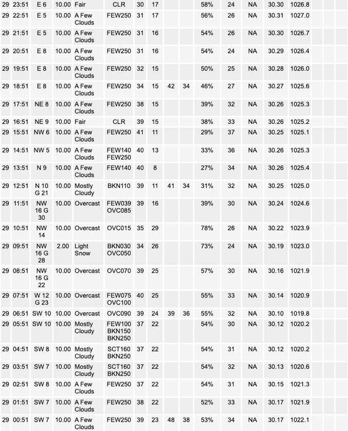
Water vapor imagery early this morning depicts a potent northern stream shortwave impulse digging southeastward into the Upper Midwest. This feature will support a brief, but rather robust, period of deep layer forced ascent into parts of the Great Lakes region this morning as it races southeastward into Lower Michigan into the early afternoon. While northeastern IL and parts of far northwestern IN only get grazed by this disturbance, a surface cold front now shifting southeastward into southwestern WI and northeastern IA is expected to be the impetus for a narrow band of snow as is shifts into the area this morning.
Radar imagery indicates that this narrow band of snow is already underway to our north-northwest, just in the wake of the surface frontal boundary in a region of enhanced low to mid-level frontogenesis. The band of snow is expected to track southeastward into far northern sections of IL around daybreak, before shifting across northeastern IL into far northwestern IN during the mid to late morning hours. The progressive nature of front should only support around an hour duration of snow at any given location this morning, so no big amounts are expected. Some minor accumulations (half inch or less) remain possible, however, especially across far northern IL (north of I-88) where temperatures will be the coolest early this morning. Some slick spots may develop in this area given the timing of the snow early in the morning, but may end up be more limited to bridges and overpasses given the marginal surface temperatures.
A period of blustery northwesterly winds (gusting 25 to 30 mph) is also expected to accompany the cold frontal passage this morning, but speeds are expected to ease through the day. Skies will become mostly sunny from northwest to southeast this afternoon in the wake of the morning snow. With our late March sun angle, afternoon temperatures are expected to rebound back into the upper 30s to near 40 across northern IL. Surface high pressure then quickly shifts southeastward across the area tonight. Clear skies and light winds with this high should in turn set up a chilly night, with readings bottoming out in the 20s.
KJB/NWS Chicago
