
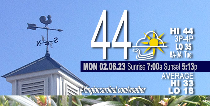
Monday Hi 44, partly cloudy to partly sunny, winds SE to S, 10 to 23 MPH, G16 to 37 MPH
NWS CHGO | NWS HRLY | /NWSchicago | 🌡
ARLINGTON HEIGHTS WEATHER
▴ forecast7 (Arl. Hts.) | RADAR | WIDE RADAR
⏪ Hrly Data Table | Hrly Future Graph ⏩
IMPORTANT NOTE ON NWS DATA
⏪ Hrly Data Table | Hrly Future Graph ⏩
======================
Monday and Monday Night …
No Weather Hazards expected …
No weather hazards expected Monday, but gusty winds will peak to about 37 MPH around midnight and continue into Tuesday morning.
DISCUSSION…
A progressive northern stream upper trough will move east-southeast across the Canadian prairie provinces today and Ontario tonight. Low-level response ahead of this will be increasing south-southeast winds that will draw warmer air northward, which supports mid 40s for highs in areas with no snow cover. Cooler temperatures will be found over the still snow-covered locations north of I-88. Gusty winds should speed up snow cover loss with evaporation and sublimation. There will be some variability in high clouds today, but that should have a limited influence on temperatures.
Daily low temperatures and daily high temperatures are on the way up. Normal temperature stats milestone Monday: Rise of normal daily high from 32°F to 33°F. We’re gaining about 2 minutes of daylight every day in the progression toward vernal equinox, March 20, 2023. We gained three minutes of daylight yesterday, Sunday, February 5, 2023.
======================
O’HARE FORECAST …
Forecast Beginning Monday, Feb. 06, 2023
Monday: Partly sunny, with a high near 44. South southeast wind 10 to 15 mph, with gusts as high as 30 mph.
Monday Night: Showers likely, mainly before 4am. Increasing clouds, with a temperature rising to around 47 by 2am. Breezy, with a south southeast wind 20 to 25 mph becoming west southwest after midnight. Winds could gust as high as 35 mph. Chance of precipitation is 60%. New precipitation amounts of less than a tenth of an inch possible.
Tuesday: Partly sunny, with a high near 41. Breezy, with a west wind 15 to 20 mph, with gusts as high as 30 mph.
Tuesday Night: Partly cloudy, with a low around 26. West wind 5 to 10 mph becoming light after midnight. Winds could gust as high as 20 mph.
Wednesday: A 30 percent chance of rain after noon. Mostly cloudy, with a high near 42. Light and variable wind becoming east 5 to 10 mph in the morning. Winds could gust as high as 15 mph.
Wednesday Night: Rain. Low around 36. Breezy. Chance of precipitation is 80%.
Thursday: Rain likely, mainly before noon. Cloudy, with a high near 41. Breezy. Chance of precipitation is 60%.
Thursday Night: Mostly cloudy, with a low around 31.
Friday: Mostly cloudy, with a high near 35.
Friday Night: Partly cloudy, with a low around 22.
Saturday: Sunny, with a high near 34.
Saturday Night: Mostly clear, with a low around 26.
Sunday: Partly sunny, with a high near 44. Breezy.


CHICAGOWEATHERSTATION.COM

ChicagoWeatherStation.com I O’Hare Normal Temps/Precip I O’Hare Record Temps, Precip, Snow
LIVE RADAR | STORM TRACKS | UNISYS US IR SAT | UNISYS Midwest IR SAT | UNISYS More IR SAT
WunderMap® with Temperature/Wind Data || Google: Arlington Heights Area Temps | US TEMPS
Full Screen Motion Weather Radar (Wunderground.com)
Midwest Cloud Cover with Arlington Heights Weather Forecast
ChicagoWeatherStation.com I O’Hare Normal Temps/Precip I O’Hare Record Temps, Precip, Snow
SUNLIGHT DATA FOR SECURITY, TRAFFIC SAFETY, AND SPORTS
SunCalc.net data with solar azimuth and trajectory, times for dawn, sunrise, solar noon, sunset, dusk …
NIGHT SKY THIS MONTH …
Backyard stargazers get a monthly guide to the northern hemisphere’s skywatching events with “Tonight’s Sky.” Check the night sky objects for this month and past months in the playlist from the Space Telescope Science Institute YouTube channel (Musical track The Far River written by Jonn Serrie, from the album And the Stars Go With You courtesy of New World Music Ltd).
Get updates from The Cardinal ALL NEWS FEEDS on Facebook. Just ‘LIKE’ the ‘Arlington Cardinal Page (become a fan of our page). The updates cover all posts and sub-category posts from The Cardinal — Arlingtoncardinal.com. You can also limit feeds to specific categories. See all of The Cardinal Facebook fan pages at Arlingtoncardinal.com/about/facebook …
Help fund The Cardinal Arlingtoncardinal.com/sponsor
Area Forecast Discussion
National Weather Service Chicago/Romeoville, IL
545 AM CST Mon Feb 6 2023
.SHORT TERM… Issued at 212 AM CST Mon Feb 6 2023
Through Tuesday…
Key messages:
* Areas of fog over north central Illinois early this morning, some dense with locally slick pavement possible underneath
* Windy tonight, with south winds gusting 30 to 40 mph
* Scattered light rain showers late this evening into overnight
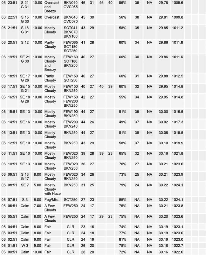
High pressure of 1022 mb centered over the Illinois/Indiana state line early this morning has provided a calm boundary layer to start today. This setup over residual snow cover in parts of north central Illinois has aided in shallow fog development. GOES-16 nighttime microphysics RGB indicates this is mainly along and west of the Fox River Valley, and webcams have shown temporary dense conditions, although also highlight the shallow nature of the fog. Am not anticipating a Dense Fog Advisory as of this writing, but given temperatures are in the teens within the fog, will message local slick spots possible where fog is encountered. With increasing low-level flow atop the boundary layer by daybreak, this fog should dissipate fairly readily between 7 and 8 AM.
A progressive northern stream upper trough will scoot east- southeast across the Canadian prairie provinces today and Ontario tonight. Low-level response ahead of this will be increasing south-southeast winds that will draw warmer air northward — on the order of 3C at 925 mb this afternoon. This supports mid 40s for highs with no snow cover based on Chicago ORD climatology for early February, and that seems reasonable. Cooler temperatures will be found over the still snow covered locations north of I-88. There will be some variability in high clouds today but that should have a limited influence on temperatures.
For tonight, the maximum of the low-level response will pass over the area in the form of a 65 kt low-level jet and pressure falls of 6 mb per 6 hours. The southerly direction of the increasing winds will steer the warm sector northward and temperatures are forecast to moderate well into the 40s from mid-evening into early overnight. This should allow the boundary layer to remain mixed with potential to tap into gusts of 40 mph, which is the forecast wind speed on the RAP at only 800 ft from 9 PM to 3 AM. The low-level winds will also provide a source of moisture transport. Confluence ahead of the front as well as a zone of lift under a 120 kt upper jet should support scattered light rain showers. The depiction from convection-allowing models (CAMs) of a few hour wide zone of pre-frontal showers seems reasonable. These may not clear northwest Indiana until mid-morning Tuesday.
Behind the system cold front on Tuesday, the progressive nature of the pattern favors clearing from west-to-east in the afternoon. While cold advection will likely result in temperatures falling during the morning hours, these are forecast to rebound slightly in the afternoon to values still above normal for the time of year (upper 30s north to mid 40s south).
MTF/NWS Chicago
