
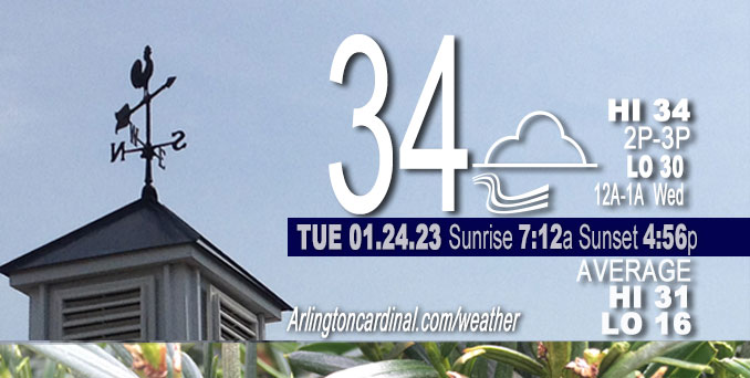
Tuesday Hi 34, mostly cloudy, winds WNW to WSW to SW to SE, 8 to 3 to 5 MPH
NWS CHGO | NWS HRLY | /NWSchicago | 🌡
ARLINGTON HEIGHTS WEATHER
▴ forecast7 (Arl. Hts.) | RADAR | WIDE RADAR
⏪ Hrly Data Table | Hrly Future Graph ⏩
IMPORTANT NOTE ON NWS DATA
⏪ Hrly Data Table | Hrly Future Graph ⏩
======================
Tuesday and Tuesday Night …
Weather Hazards expected …
Limited Snow Risk. Winter Weather Advisories I-80 and south.
DISCUSSION…
Snow will move into the area late Tuesday night — after midnight in Arlington Heights and nearby communities. Minor accumulations overnight Tuesday/Wednesday will be followed by additional accumulations and travel impacts through the day Wednesday.
Less than one week left of the normal daily low temperature bottomed out at 16°F. Daily high increases from 31°F to 32°F in seven days. We’re gaining about 2 minutes of daylight every day in the progression toward vernal equinox, March 20, 2023.
======================
O’HARE FORECAST …
Forecast Beginning Tuesday, Jan. 24, 2023
Tuesday: Cloudy, with a high near 34. Southwest wind 5 to 10 mph.
Tuesday Night: Snow, mainly after 4am. Low around 30. South wind 5 to 10 mph becoming east northeast after midnight. Winds could gust as high as 15 mph. Chance of precipitation is 80%. New snow accumulation of less than a half inch possible.
Wednesday: Snow. High near 34. North wind 10 to 15 mph, with gusts as high as 25 mph. Chance of precipitation is 100%. New snow accumulation of 2 to 4 inches possible.
Wednesday Night: A 30 percent chance of snow, mainly before midnight. Cloudy, with a low around 28. Northwest wind 10 to 15 mph, with gusts as high as 25 mph.
Thursday: A 20 percent chance of snow showers. Cloudy, with a high near 31. Northwest wind around 10 mph, with gusts as high as 15 mph.
Thursday Night: Mostly cloudy, with a low around 20.
Friday: A 40 percent chance of snow after noon. Cloudy, with a high near 36. Breezy.
Friday Night: Cloudy, with a low around 21. Breezy.
Saturday: Cloudy, with a high near 27.
Saturday Night: A chance of snow. Cloudy, with a low around 16.
Sunday: Cloudy, with a high near 24.
Sunday Night: Cloudy, with a low around 10.
Monday: Mostly cloudy, with a high near 19.


CHICAGOWEATHERSTATION.COM

ChicagoWeatherStation.com I O’Hare Normal Temps/Precip I O’Hare Record Temps, Precip, Snow
LIVE RADAR | STORM TRACKS | UNISYS US IR SAT | UNISYS Midwest IR SAT | UNISYS More IR SAT
WunderMap® with Temperature/Wind Data || Google: Arlington Heights Area Temps | US TEMPS
Full Screen Motion Weather Radar (Wunderground.com)
Midwest Cloud Cover with Arlington Heights Weather Forecast
ChicagoWeatherStation.com I O’Hare Normal Temps/Precip I O’Hare Record Temps, Precip, Snow
SUNLIGHT DATA FOR SECURITY, TRAFFIC SAFETY, AND SPORTS
SunCalc.net data with solar azimuth and trajectory, times for dawn, sunrise, solar noon, sunset, dusk …
NIGHT SKY THIS MONTH …
Backyard stargazers get a monthly guide to the northern hemisphere’s skywatching events with “Tonight’s Sky.” Check the night sky objects for this month and past months in the playlist from the Space Telescope Science Institute YouTube channel (Musical track The Far River written by Jonn Serrie, from the album And the Stars Go With You courtesy of New World Music Ltd).
Get updates from The Cardinal ALL NEWS FEEDS on Facebook. Just ‘LIKE’ the ‘Arlington Cardinal Page (become a fan of our page). The updates cover all posts and sub-category posts from The Cardinal — Arlingtoncardinal.com. You can also limit feeds to specific categories. See all of The Cardinal Facebook fan pages at Arlingtoncardinal.com/about/facebook …
Help fund The Cardinal Arlingtoncardinal.com/sponsor
Area Forecast Discussion
National Weather Service Chicago/Romeoville, IL
603 AM CST Tue Jan 24 2023
.SHORT TERM… Issued at 225 AM CST Tue Jan 24 2023
Through Wednesday Night…
The main bullet points and headline decisions are outlined below. Will follow up with a more thorough discussion by about 5 AM.
* Widespread accumulating snow is on track to overspread our region late tonight and into Wednesday.
* Guidance converging on a consensus low track which may bring higher totals right up to (if not into) Benton County.
* Winter Weather Advisories hoisted for our I-80 and south locales late tonight through Wednesday afternoon. While the end time of the advisory currently runs until 6 PM, our primary window of concern for travel impacts is generally one to two hours after snow onset and through about 11 AM or noon on Wednesday. Afterwards, warming temperatures and diminishing snowfall intensity should begin to help melt snow and diminish travel impacts.
* For Benton County: elected to hoist a higher-end advisory (3 to 6 inches), but given recent model trends, warning-criteria snowfall is within reach (storm track dependent) and we will need to keep an eye on things with a potential for quite heavy snowfall rates Wednesday morning.
* Currently, have left central Cook (Chicago), northern Cook, and DuPage counties out of the Advisory. While explicit snowfall amounts through Wednesday PM are about 1-3/2-4 inches, we have lingering questions regarding already marginal surface temperatures and potential for mild lake influence to really temper roadway accumulations and impacts. If guidance continues to trend faster with snow onset, more snow would fall during a favorable time for roadway accumulations and attendant impacts to the morning commute. Conversely, a later arrival would result in greatly reduced travel impact potential and any accumulations being relegated almost entirely to grassy and very elevated surfaces.
* Seeing some signs in guidance tonight for some elevated instability being available as snow starts. This could result in a quick burst of snowfall and associated slick travel conditions, even with lighter accumulations (<1-2 inches). Updated at 438 AM CST to add additional information: Early-morning moisture channel loops reveal an area of strong cyclonic shear vorticity near I-80 which is acting on a region of enhanced low-level moisture. Noting several pockets of very light radar returns out of this pushing east across Livingston and Kankakee counties. Earlier report relayed by Davenport/Quad cities was this was very light snow as it pushed over their office. With a lack of observations (did see PNT just come in with -SN) and noting 4-5 sm mist reports, and given IR satellite showing cloud top temperatures are hardly colder than about -5 C, suspect there`s probably a little freezing drizzle embedded in there as well. Thankfully, this area of returns is moving along, so residence time will be short and should help curtail the threat for more significant issues. Have expanded the area of light snow and freezing drizzle mix to all locales south of I-80 through early this morning. Pretty quiet otherwise today as we await our storm system which is just now curling eastward towards the Trans-Pecos. Trend in the guidance tonight has been to meet somewhere in the middle (earlier NW outliers have shifted a smidge SE and SE clusters have moved a hair NW). While this hasn`t really resulted in any meaningful change to the forecast, it does somewhat increase the chances that our far southeast (Benton County in particular) gets closer to the impressive f-gen band and zone of briefly very heavy snowfall rates on Wednesday morning. Trend has also been towards a slightly faster onset time of snow. Light snow is expected to break out across our far south perhaps around midnight tonight, before progressing north towards the I-88 corridor around 2-5 AM. One item we`re noting is the presence (pretty ubiquitous across the guidance suite) of an antecedent plume of conditionally unstable air ahead of the main area of snow. With this in place, it`s plausible that "fingers" of enhanced snow rates develop a few hours after onset of initial snowfall, even across our northwest Illinois counties, resulting in bursts of heavier snowfall rates. These would likely be transient, but have the potential to cause some travel issues outside the current advisory. Think this is also why, in concert with an itty bitty secondary anticyclonic jet streak, guidance like the GFS is starting to paint a secondary "maxima" in snowfall into the Rockford area into Wednesday morning. Updated snowfall forecast reflects slightly higher amounts into the Rockford area. Regarding the advisory area: as mentioned in the main bullet points, a Winter Weather Advisory was hoisted for all of our I-80 and south locales where confidence in snow breaking out early enough and getting steady enough before sunrise to cause quick roadway accumulations was highest during the morning commute. Gave serious consideration to include DuPage and central and northern Cook with this package, but we continue to battle with whether better rates will arrive early enough in the morning. It seems pretty clear that by mid morning, temperatures will begin rising to near or even above freezing (and it`s likely our lake- adjacent locales start out just above freezing), so a later arrival of snowfall would mean a reduced temporal overlap with the ideal window for roadway accumulations. Will let the day shift get a look of things for a potential expansion. Keeping a very close eye on our far SE locales, with a close enough approach of the system TROWAL and extremely steep lapse rates (fully upright unstable) to pinwheel a region of 1+"/hr rates into Benton County Wednesday morning. Any slight SE shift/wobble in the low track would reduce this risk, however, so just too uncertain to justify a warning there. Finally: while not a cohesive signal, a local minima in snowfall actually seems possible somewhere in the vicinity of the Kankakee River where mesoscale subsidence in the northwest flanks of the primary f-gen circulation may develop. No way to pinpoint this with any reliability, though, so it`s just more of a meteorological observation than anything at this range... Impacts should ease through the afternoon as rates diminish and temperatures "warm" a bit. End time of the advisory may be a bit on the long side, but this matches up with neighbors well and leaves some wiggle room for lingering spotty road issues. LES potential still doesn`t look amazing, but modest enough parameter space that we`ll likely see snow showers continue into Wednesday evening while shifting incrementally into northwest Indiana. An additional 1-2 inches seem possible across NE Lake and northern Porter counties into Wednesday night. Carlaw/NWS Chicago
