
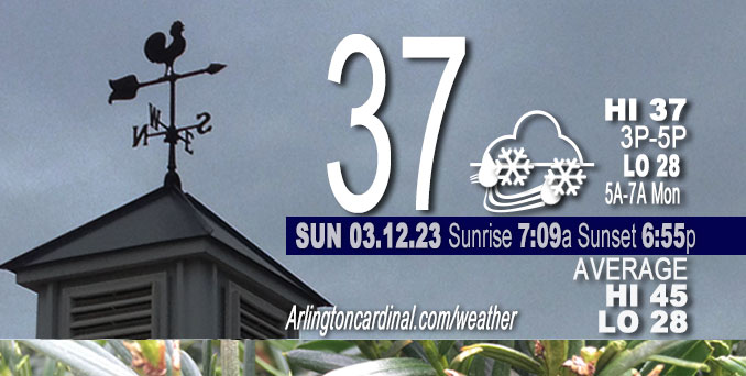
Sunday Hi 37, partly sunny to mostly cloudy, light snow, rain, mist, winds SE to S to SW to WSW, 6 to 14 to 13 MPH, G15 to 23 to 18 MPH into Monday
NWS CHGO | NWS HRLY | /NWSchicago | 🌡
ARLINGTON HEIGHTS WEATHER
▴ forecast7 (Arl. Hts.) | RADAR | WIDE RADAR
⏪ Hrly Data Table | Hrly Future Graph ⏩
IMPORTANT NOTE ON NWS DATA
⏪ Hrly Data Table | Hrly Future Graph ⏩
Hello mobile users! If you encounter a mobile “unfriendly” weather page, turn your phone sideways for a better view.
======================
Sunday and Sunday Evening …
Weather Hazards expected …
Limited Snow Risk with snow accumulation expected to be about 0.6″ from 3:00 p.m. Sunday to 1:00 p.m. Monday.
DISCUSSION…
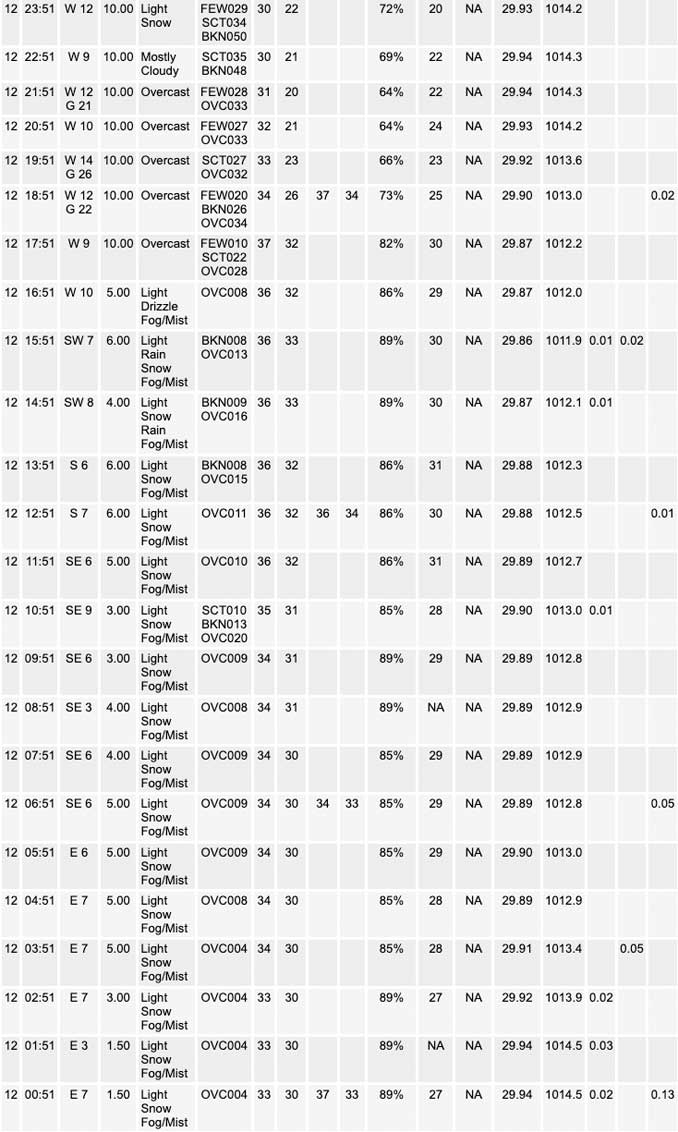
A band of snow showers early this evening over northeast Illinois and northwest Indiana may reduce visibility to briefly one mile or less.
Additional snow showers develoRCping in the pre-dawn hours could cause localized travel impacts due to visibility under one mile at times and spotty coatings of snow, including on some roads.
Cooler temperatures through early next week then rebounding Wednesday to a high in the upper 40s Wednesday and in the low 50s Thursday.
Additional 3 minutes of daylight on Sunday, March 12, 2023 with spring forward to Daylight Savings Time.
======================
O’HARE FORECAST …
Forecast Beginning Sunday, Mar. 12, 2023
Sunday: Snow showers likely. Cloudy, with a high near 37. Southwest wind around 5 mph. Chance of precipitation is 60%. Total daytime snow accumulation of less than a half inch possible.
Sunday Night: Snow showers before 9pm, then scattered snow showers after 2am. Low around 28. West wind 10 to 15 mph, with gusts as high as 25 mph. Chance of precipitation is 80%. New snow accumulation of less than a half inch possible.
Monday: Scattered snow showers before 1pm, then scattered flurries between 1pm and 4pm, then isolated snow showers after 4pm. Cloudy, with a high near 35. Breezy, with a north northwest wind 10 to 20 mph, with gusts as high as 25 mph. Chance of precipitation is 40%.
Monday Night: Isolated snow showers before 7pm, then scattered flurries between 7pm and 1am. Mostly cloudy, with a low around 21. North northwest wind 10 to 15 mph, with gusts as high as 20 mph. Chance of precipitation is 10%.
Tuesday: Sunny, with a high near 35. North northwest wind around 10 mph, with gusts as high as 15 mph.
Tuesday Night: Mostly clear, with a low around 22.
Wednesday: Mostly sunny, with a high near 48.
Wednesday Night: Mostly cloudy, with a low around 39.
Thursday: Showers likely, mainly after 1pm. Cloudy, with a high near 51.
Thursday Night: Rain. Cloudy, with a low around 37.
Friday: A chance of rain and snow. Mostly cloudy, with a high near 41. Breezy.
Friday Night: Mostly cloudy, with a low around 23. Breezy.
Saturday: Partly sunny, with a high near 33. Breezy.


CHICAGOWEATHERSTATION.COM

ChicagoWeatherStation.com I O’Hare Normal Temps/Precip I O’Hare Record Temps, Precip, Snow
LIVE RADAR | STORM TRACKS | UNISYS US IR SAT | UNISYS Midwest IR SAT | UNISYS More IR SAT
WunderMap® with Temperature/Wind Data || Google: Arlington Heights Area Temps | US TEMPS
Full Screen Motion Weather Radar (Wunderground.com)
Midwest Cloud Cover with Arlington Heights Weather Forecast
ChicagoWeatherStation.com I O’Hare Normal Temps/Precip I O’Hare Record Temps, Precip, Snow
SUNLIGHT DATA FOR SECURITY, TRAFFIC SAFETY, AND SPORTS
SunCalc.net data with solar azimuth and trajectory, times for dawn, sunrise, solar noon, sunset, dusk …
NIGHT SKY THIS MONTH …
Backyard stargazers get a monthly guide to the northern hemisphere’s skywatching events with “Tonight’s Sky.” Check the night sky objects for this month and past months in the playlist from the Space Telescope Science Institute YouTube channel (Musical track The Far River written by Jonn Serrie, from the album And the Stars Go With You courtesy of New World Music Ltd).
Get updates from The Cardinal ALL NEWS FEEDS on Facebook. Just ‘LIKE’ the ‘Arlington Cardinal Page (become a fan of our page). The updates cover all posts and sub-category posts from The Cardinal — Arlingtoncardinal.com. You can also limit feeds to specific categories. See all of The Cardinal Facebook fan pages at Arlingtoncardinal.com/about/facebook …
Help fund The Cardinal Arlingtoncardinal.com/sponsor
Area Forecast Discussion
National Weather Service Chicago/Romeoville, IL
638 AM CDT Sun Mar 12 2023
.SHORT TERM… Issued at 305 AM CDT Sun Mar 12 2023
Through Monday…
Happy time change!
Regional water vapor imagery depicts a wound-up closed upper-level low meandering into western Minnesota upstream of a shearing-apart wave over the Lower Great Lakes. Low clouds, mist, and even a few pockets of drizzle are prevalent across Iowa and western IL within a low-level pressure col (e.g. stagnation zone in the winds), which is due to slide east over our area later this morning. Accordingly, we`ll start our day gray and somewhat moist. This afternoon, a cold front will sweep across our area ushering in blustery west winds and falling temperatures. A band of showers (rain mixed with snow) should develop virtually overhead as the front passes through with flurries and occasional brief snow showers prevailing through the overnight hours. Lows will dro Pinto the mid to upper 20s overnight.
Monday morning, the center of the upper-level low is expected to pivot over northeastern Illinois ushering in a reinforcing shot of cold air. With steep low- to mid-level lapse rates within the core of the low, a flare in snow showers is expected during the Monday morning commute particularly over the Chicago area. Accordingly, we`ll have to watch for a few slick spots during the Monday morning commute particularly where snow showers are most prevalent. Snow showers and flurries will then continue into the afternoon hours with the highest coverage in northwestern Indiana thanks to an increasing connection to the unstable waters off Lake Michigan. While highs Monday will “only” climb into the upper 20s to lower 30s, overcast skies and blustery northwest winds will make it feel more like the upper teens to lower 20s.
Borchardt/NWS Chicago
