
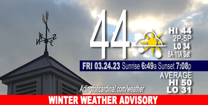
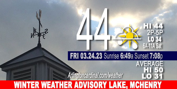
Friday Hi 44, partly sunny to mostly cloudy, rain after 9p, winds ENE to NE, 11 to 10 to 14 MPH, G17 to 16 to 24 MPH, increasing Saturday
NWS CHGO | NWS HRLY | /NWSchicago | 🌡
ARLINGTON HEIGHTS WEATHER
▴ forecast7 (Arl. Hts.) | RADAR | WIDE RADAR
⏪ Hrly Data Table | Hrly Future Graph ⏩
IMPORTANT NOTE ON NWS DATA
⏪ Hrly Data Table | Hrly Future Graph ⏩
Hello mobile users! If you encounter a mobile “unfriendly” weather page, turn your phone sideways for a better view.
======================
Friday and Friday Evening …
Weather Hazards expected …
Elevated Snow Risk Late Tonight (not until 4:00 a.m. Saturday for Arlington Heights and nearby communities).
DISCUSSION…
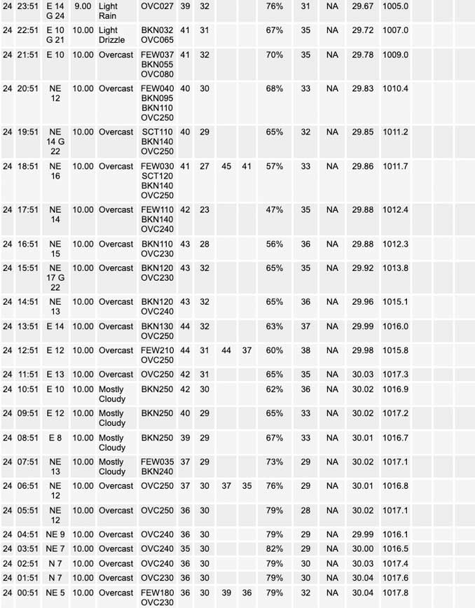
Rain beginning this evening will transition to wet snow late tonight into tomorrow morning, mainly for areas near and north of I-88. Several inches of wet snow accumulation is expected north of I-88 and especially near the Wisconsin stateline.
======================
Winter Weather Advisory URGENT – WINTER WEATHER MESSAGE National Weather Service Chicago IL 1036 AM CDT Fri Mar 24 2023
Winnebago-Boone-McHenry-Lake IL-Ogle- Including the cities of Rockford, Belvidere, Crystal Lake, Algonquin, McHenry, Woodstock, Waukegan, Buffalo Grove, Mundelein, Gurnee, Rochelle, Oregon, and Byron 1036 AM CDT Fri Mar 24 2023
…WINTER WEATHER ADVISORY REMAINS IN EFFECT FROM 4 AM TO 1 PM CDT SATURDAY…
* WHAT…Accumulating wet snow expected. Total snow accumulations of 4 to 7 inches, with locally higher amounts possible.
* WHERE…Winnebago, Boone, McHenry, Lake (IL), and Ogle Counties.
* WHEN…From 4 AM to 1 PM CDT Saturday.
* IMPACTS…Untreated roads will become covered with slushy snow accumulations and travel may become difficult for a period early Saturday morning during the period of heaviest snow.
* ADDITIONAL DETAILS…Snow rates are likely to peak at 1 to 1.5 inches per hour late tonight into early Saturday morning. The expected heavy, wet nature of the snow will make shoveling hazardous.
PRECAUTIONARY/PREPAREDNESS ACTIONS…
Slow down and use caution while traveling.
The latest road conditions for Illinois can be obtained on the internet at www.gettingaroundillinois.com.
O’HARE FORECAST …
Forecast Beginning Friday, Mar. 24, 2023
Friday: Mostly cloudy, with a high near 44. East northeast wind around 10 mph, with gusts as high as 15 mph.
Friday Night: Rain before 4am, then rain, possibly mixed with snow. Low around 34. East northeast wind 10 to 15 mph, with gusts as high as 25 mph. Chance of precipitation is 100%. New snow accumulation of less than a half inch possible.
Saturday: Rain and snow before 4pm, then a slight chance of rain. High near 38. North northeast wind around 15 mph becoming west northwest in the afternoon. Winds could gust as high as 30 mph. Chance of precipitation is 90%. New snow accumulation of 1 to 3 inches possible.
Saturday Night: Partly cloudy, with a low around 29. West wind 5 to 15 mph, with gusts as high as 20 mph.
Sunday: Mostly sunny, with a high near 47. West northwest wind around 5 mph becoming north northeast in the afternoon. Winds could gust as high as 10 mph.
Sunday Night: A slight chance of rain and snow between 1am and 4am, then a slight chance of rain after 4am. Mostly cloudy, with a low around 32. Chance of precipitation is 20%.
Monday: A 20 percent chance of rain before 1pm. Partly sunny, with a high near 46.
Monday Night: Mostly cloudy, with a low around 34.
Tuesday: Mostly sunny, with a high near 49.
Tuesday Night: Partly cloudy, with a low around 33.
Wednesday: Partly sunny, with a high near 48.
Wednesday Night: A chance of showers. Mostly cloudy, with a low around 36.
Thursday: A chance of showers. Partly sunny, with a high near 53.


CHICAGOWEATHERSTATION.COM

ChicagoWeatherStation.com I O’Hare Normal Temps/Precip I O’Hare Record Temps, Precip, Snow
LIVE RADAR | STORM TRACKS | UNISYS US IR SAT | UNISYS Midwest IR SAT | UNISYS More IR SAT
WunderMap® with Temperature/Wind Data || Google: Arlington Heights Area Temps | US TEMPS
Full Screen Motion Weather Radar (Wunderground.com)
Midwest Cloud Cover with Arlington Heights Weather Forecast
ChicagoWeatherStation.com I O’Hare Normal Temps/Precip I O’Hare Record Temps, Precip, Snow
SUNLIGHT DATA FOR SECURITY, TRAFFIC SAFETY, AND SPORTS
SunCalc.net data with solar azimuth and trajectory, times for dawn, sunrise, solar noon, sunset, dusk …
NIGHT SKY THIS MONTH …
Backyard stargazers get a monthly guide to the northern hemisphere’s skywatching events with “Tonight’s Sky.” Check the night sky objects for this month and past months in the playlist from the Space Telescope Science Institute YouTube channel (Musical track The Far River written by Jonn Serrie, from the album And the Stars Go With You courtesy of New World Music Ltd).
Get updates from The Cardinal ALL NEWS FEEDS on Facebook. Just ‘LIKE’ the ‘Arlington Cardinal Page (become a fan of our page). The updates cover all posts and sub-category posts from The Cardinal — Arlingtoncardinal.com. You can also limit feeds to specific categories. See all of The Cardinal Facebook fan pages at Arlingtoncardinal.com/about/facebook …
Help fund The Cardinal Arlingtoncardinal.com/sponsor
/////////////>
Area Forecast Discussion
National Weather Service Chicago/Romeoville, IL
659 AM CDT Thu Mar 23 2023
.SHORT TERM… Issued at 400 AM CDT Thu Mar 23 2023
Through Friday…
Main forecast points:
* Scattered showers and thunderstorms this morning, diminishing from north to south as a cold front pushes through.
* Temperatures falling into the 30s and low 40s behind the front today.
* Showers return south of I-80 Friday afternoon.
Early morning surface analyses depicts a stationary front from central MO into northern IN, with a weak low pressure wave along the IL/IN border southeast of Kankakee. A cold front stretching from lower MI into northern IL will merge with within the stationary frontal trough this morning, with the resulting strong cold front pushing south into central IL/IN through midday. Along and south of the boundary, a 45-50 knot southwesterly low level jet was providing moisture transport into the frontal zone, beneath a region of steep mid-level lapse rates on the order of 7-8 C/km. This was producing areas of convective showers and scattered thunderstorms along and north of the surface stationary front early this morning, though the MUCAPE axis is expected to shift south with the frontal zone through mid-late morning.
Combined with gradual mid-level drying from the west, this will shift the main focus for showers and scattered thunderstorms largely south of the forecast area by midday, though scattered showers may linger south of U.S. highway 24 through the afternoon. As the front pushes south, blustery north winds will bring cooler air into the forecast area. Current temps were in the lower 50s across the far southern parts of the cwa, though low-mid 30s were about to spill across the IL/WI border from the north. Thus, falling temperatures are expected for most areas this morning with daytime temps eventually settling in the lower 40s across most of the area, with even some upper 30s along the Lake Michigan shore as winds turn onshore.
The frontal zone is progged to stall across the Ohio Valley tonight, with forcing increasing due to increasing frontogenesis beneath the divergent right entrance region of a 150+ kt upper level jet streak across the Great Lakes. Rain is expected to increase north of the surface front mainly across central IL/IN, though some showers may affect far southern parts of the cwa overnight along the WFO LOT/ILX border. Developing surface low pressure will then track from the Southern Plains toward the lower Missouri Valley on Friday, increasing southerly return flow over the frontal zone during the day. This will lead to gradually increasing rain chances south of the I-80 corridor during the later afternoon hours. Otherwise, northeast winds off of Lake Michigan will limit temperatures to the 40s Friday, and to only around 40 along the lake shore.
Ratzer/NWS Chicago
