
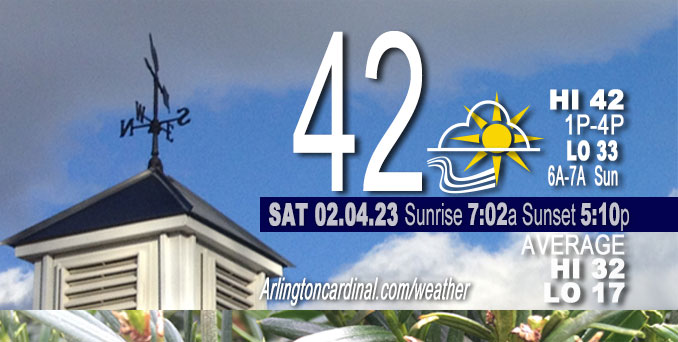
Saturday Hi 38 to 42, mostly cloudy to partly cloudy to mostly cloudy, winds NW to SW to SSW, 10 to 5 to 9 MPH, G21 to 15 MPH, ending 6a
NWS CHGO | NWS HRLY | /NWSchicago | 🌡
ARLINGTON HEIGHTS WEATHER
▴ forecast7 (Arl. Hts.) | RADAR | WIDE RADAR
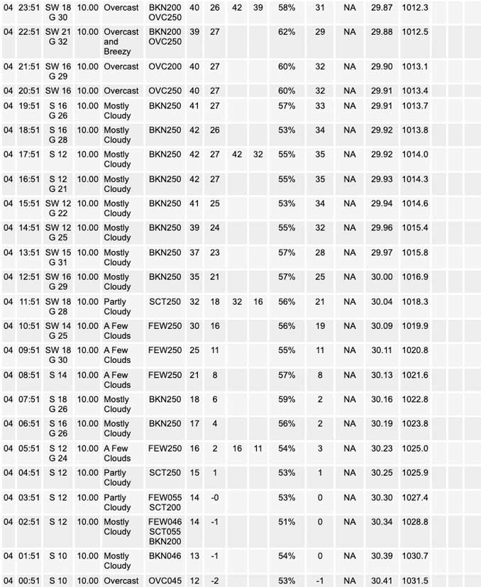
⏪ Hrly Data Table | Hrly Future Graph ⏩
IMPORTANT NOTE ON NWS DATA
⏪ Hrly Data Table | Hrly Future Graph ⏩
======================
Saturday and Saturday Night …
Weather Hazards expected …
[Data missing] Hazardous weather might have been strong non-thunderstorm winds; southwest winds in the 35 to 40 mph range Saturday afternoon and Saturday evening. Wind gusts peaked between 2:00 p.m. and 3:00 p.m.
DISCUSSION…
Temperatures will slowly rise Saturday morning and will continue to rise into Saturday afternoon. Highs Saturday and Sunday are likely to reach the lower to mid 40s south of I-80, but there remains uncertainty for highs over the deeper snow pack across northern IL and have
capped highs both days in the mid 30s. Across the Chicago metro, upper 30s to near 40 seem possible.
Daily low temperatures and daily high temperatures are on the way up. We’re gaining about 2 minutes of daylight every day in the progression toward vernal equinox, March 20, 2023.
======================
O’HARE FORECAST …
Forecast Beginning Saturday, Feb. 04, 2023
Saturday: Mostly sunny, with a high near 38. Breezy, with a south southwest wind around 20 mph, with gusts as high as 30 mph.
Saturday Night: Mostly cloudy, with a low around 32. Breezy, with a southwest wind 15 to 20 mph, with gusts as high as 30 mph.
Sunday: Mostly cloudy, with a steady temperature around 35. West southwest wind 10 to 15 mph, with gusts as high as 25 mph.
Sunday Night: Mostly cloudy, with a low around 25. West northwest wind 5 to 10 mph becoming east after midnight. Winds could gust as high as 15 mph.
Monday: Partly sunny, with a high near 44. Breezy, with a south southeast wind 5 to 10 mph increasing to 15 to 20 mph in the afternoon. Winds could gust as high as 30 mph.
Monday Night: A 30 percent chance of showers, mainly after midnight. Cloudy, with a low around 38. Breezy.
Tuesday: Mostly cloudy, with a high near 43. Breezy.
Tuesday Night: Partly cloudy, with a low around 27.
Wednesday: Mostly sunny, with a high near 44.
Wednesday Night: A chance of rain. Mostly cloudy, with a low around 35.
Thursday: A chance of rain. Partly sunny, with a high near 44.
Thursday Night: Mostly cloudy, with a low around 32.
Friday: Mostly cloudy, with a high near 36.


CHICAGOWEATHERSTATION.COM

ChicagoWeatherStation.com I O’Hare Normal Temps/Precip I O’Hare Record Temps, Precip, Snow
LIVE RADAR | STORM TRACKS | UNISYS US IR SAT | UNISYS Midwest IR SAT | UNISYS More IR SAT
WunderMap® with Temperature/Wind Data || Google: Arlington Heights Area Temps | US TEMPS
Full Screen Motion Weather Radar (Wunderground.com)
Midwest Cloud Cover with Arlington Heights Weather Forecast
ChicagoWeatherStation.com I O’Hare Normal Temps/Precip I O’Hare Record Temps, Precip, Snow
SUNLIGHT DATA FOR SECURITY, TRAFFIC SAFETY, AND SPORTS
SunCalc.net data with solar azimuth and trajectory, times for dawn, sunrise, solar noon, sunset, dusk …
NIGHT SKY THIS MONTH …
Backyard stargazers get a monthly guide to the northern hemisphere’s skywatching events with “Tonight’s Sky.” Check the night sky objects for this month and past months in the playlist from the Space Telescope Science Institute YouTube channel (Musical track The Far River written by Jonn Serrie, from the album And the Stars Go With You courtesy of New World Music Ltd).
Get updates from The Cardinal ALL NEWS FEEDS on Facebook. Just ‘LIKE’ the ‘Arlington Cardinal Page (become a fan of our page). The updates cover all posts and sub-category posts from The Cardinal — Arlingtoncardinal.com. You can also limit feeds to specific categories. See all of The Cardinal Facebook fan pages at Arlingtoncardinal.com/about/facebook …
Help fund The Cardinal Arlingtoncardinal.com/sponsor
Area Forecast Discussion
National Weather Service Chicago/Romeoville, IL
537 AM CST Sat Feb 4 2023
.SHORT TERM… Issued at 118 AM CST Sat Feb 4 2023
Through Sunday…
Primary forecast concern is strong/gusty southwesterly winds today into tonight.
High pressure is shifting east early this morning and the gradient will steadily tighten today with southwest winds gusting into the 35 to 40 mph range this afternoon and this evening. There remains some uncertainty for how frequent the strongest gusts will become and its possible prevailing gusts may remain in the 30 mph range with the highest gusts less frequent, but overall confidence is low. A weak cold front will move across the area Sunday morning, shifting winds westerly. Gusts into the 25 mph range will be possible on Sunday.
Temperatures are now slowly rising and will continue to rise into this afternoon. Highs today and on Sunday are likely to reach the lower to mid 40s south of I-80, but there remains uncertainty for highs over the deeper snow pack across northern IL and have capped highs both days in the mid 30s. Across the Chicago metro, upper 30s to near 40 seem possible.
Some of the guidance is suggesting some fog may develop Sunday morning across parts of northwest IL. While dewpoints may reach the lower 30s and there will be a front passing across the area, confidence for fog is fairly low and no mention with this forecast. Lower ceilings may be more likely than fog, but trends will need to be monitored.
— CMS/NWS Chicago
