
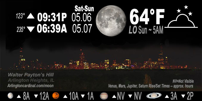
🌖 🌗 🌑 🌓 Waning Gibbous Moon, sky cover overnight Sat. to Sun. 42% to 90% to 77%, winds SSE to S to SW 11 to 8 MPH, Low 64, 5a to 6a
NWS CHGO | NWS HRLY | /NWSchicago | 🌡
ARLINGTON HEIGHTS WEATHER
▴ forecast7 (Arl. Hts.) | RADAR | WIDE RADAR
IMPORTANT NOTE ON NWS DATA
Hello mobile users! If you encounter a mobile “unfriendly” weather page, turn your phone sideways for a better view.
======================
NIGHT FORECASTS …
NOTE: Keep in mind lunar rise and set times don’t always correspond with night weather and early morning lows because on some days during the month the moon is visible in the sky predominantly during the daytime hours.
Overnight Saturday to Sunday …
No Weather Hazards expected …
Elevated Thunderstorm Risk
Limited Hail Risk…up to ping pong size
Limited Damaging Wind Risk…up to 65 mph
Limited Flooding Risk
DISCUSSION…
Additional thunderstorm development to the north and near the Quad Cities may be less organized and in lower coverage, leading to a lower coverage and/or intensity of storms in northern Illinois overnight as the thunderstorms move east. However, even with a lower coverage and perhaps less organization to thunderstorms locally overnight, steep mid-level lapse rates will still support a damaging hail threat. The peak thunderstorm window remains roughly midnight to 5 am.
======================
O’HARE FORECAST …
Forecast Beginning Saturday Night, May 06, 2023 …
Saturday Night: Showers and thunderstorms likely, mainly between 2am and 3am. Increasing clouds, with a low around 62. South southeast wind 10 to 15 mph. Chance of precipitation is 60%. New rainfall amounts between a tenth and quarter of an inch, except higher amounts possible in thunderstorms.
Sunday: A chance of showers and thunderstorms before 7am, then a slight chance of showers and thunderstorms after 4pm. Cloudy, then gradually becoming mostly sunny, with a high near 81. Southwest wind 5 to 10 mph becoming northeast in the afternoon. Winds could gust as high as 15 mph. Chance of precipitation is 30%.
Sunday Night: Showers and thunderstorms likely, mainly after 1am. Some of the storms could produce heavy rainfall. Increasing clouds, with a low around 54. East wind 5 to 10 mph. Chance of precipitation is 60%. New rainfall amounts between a half and three quarters of an inch possible.
Monday: Showers likely and possibly a thunderstorm. Mostly cloudy, with a high near 68. East northeast wind around 10 mph. Chance of precipitation is 70%.
Monday Night: A chance of showers and thunderstorms. Mostly cloudy, with a low around 53. North northeast wind 5 to 10 mph. Chance of precipitation is 50%.
Tuesday: Partly sunny, with a high near 68.
Tuesday Night: Partly cloudy, with a low around 49.
Wednesday: Sunny, with a high near 71.
Wednesday Night: Partly cloudy, with a low around 52.
Thursday: Mostly sunny, with a high near 75.
Thursday Night: Mostly cloudy, with a low around 57.
Friday: A chance of showers. Mostly cloudy, with a high near 77.
Friday Night: A chance of showers. Mostly cloudy, with a low around 59.
Saturday: A chance of showers. Partly sunny, with a high near 79.
O’Hare forecast archive and hourly weather observations archive are available HERE on the CARDINAL NEWS Magazine.
Arlingtoncardinal.com/moonphases
Arlingtoncardinal.com/nightsky
NIGHT SKY THIS MONTH …
Check the night sky objects for this month and past months in the playlist from the Space Telescope Science Institute YouTube channel Backyard stargazers get a monthly guide to the northern hemisphere’s skywatching events with “Tonight’s Sky” (Musical track The Far River written by Jonn Serrie, from the album And the Stars Go With You courtesy of New World Music Ltd. Musical track The Far River written by Jonn Serrie, from the album And the Stars Go With You courtesy of New World Music Ltd).
Telephoto lens, ISO 100, f/11, Shutter Speed 1/100 to 1/125 for the Moon.
Get updates from The Cardinal ALL NEWS FEEDS on Facebook. Just ‘LIKE’ the ‘Arlington Cardinal Page (become a fan of our page). The updates cover all posts and sub-category posts from The Cardinal — Arlingtoncardinal.com. You can also limit feeds to specific categories. See all of The Cardinal Facebook fan pages at Arlingtoncardinal.com/about/facebook …
Help fund The Cardinal Arlingtoncardinal.com/sponsor
Telephoto lens, ISO 1600, f/11, Shutter Speed 2.5″ for the skyline. The skyline exposure was toned down, and brightness and contrast was adjusted in Photoshop.
/////////////>
Area Forecast Discussion
National Weather Service Chicago/Romeoville, IL
1225 AM CDT Sat May 6 2023
.SHORT TERM… Issued at 245 PM CDT Fri May 5 2023
Through Saturday…
Dry and breezy conditions will continue through the rest of this afternoon before winds ease this evening. Until then gusts of 20 to 25 mph, with occasionally higher gusts, are expected which in combination with the low humidities will make for an elevated fire risk.
Rain chances will begin to increase this evening as the decaying remnants of the Mesoscale Convective Vortex (MCV) currently over western Iowa continues to move closer. Guidance has continued to be in agreement that sufficient moisture would return this evening which in conjunction with warm advection, would allow an area of showers to move across portions of northern Illinois overnight into early Saturday morning. However, the axis of better instability is expected to remain west of the area which should keep the showers in a decaying state as they move through. Furthermore, what limited instability was forecast to be over portions of the area has trended much weaker to the point that forecast soundings show very unimpressive lapse rates and virtually no CAPE. Therefore I have decided to pull the mention of thunder from the forecast for tonight into Saturday morning.
Showers are expected to move east and dissipate by daybreak Saturday morning for most, but a few lingering showers may be observed through the morning hours for areas along the IL-WI line. Otherwise, another dry and seasonably mild afternoon is on tap for Saturday but with notably more cloud cover. While the clouds will aid in keeping temperatures a tad cooler than today, highs are still forecast to top out in the mid-70s areawide with 60s expected for areas along the IL lakeshore. Finally, winds are also expected to once again be breezy with southeasterly gusts in the 20 to 25 mph range.
Yack/NWS Chicago
