
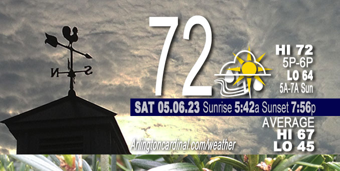
Saturday Hi 72, chance rain, mostly cloudy to partly cloudy, winds SE to SSE, 12 to 14 to 18 MPH, G18 to 21 to 18 MPH, continuing Sunday
NWS CHGO | NWS HRLY | /NWSchicago | 🌡
ARLINGTON HEIGHTS WEATHER
▴ forecast7 (Arl. Hts.) | RADAR | WIDE RADAR
⏪ Hrly Data Table | Hrly Future Graph ⏩
IMPORTANT NOTE ON NWS DATA
⏪ Hrly Data Table | Hrly Future Graph ⏩
Hello mobile users! If you encounter a mobile “unfriendly” weather page, turn your phone sideways for a better view.
======================
Saturday and Saturday Evening …
Weather Hazards expected …
Limited Thunderstorm Risk tonight.
DISCUSSION…
Saturday afternoon, a small convective complex continues to dive south across downstate IL, riding the instability gradient safely away from our area.
Severe weather is possible, but not expected.
======================
O’HARE FORECAST …
Forecast Beginning Saturday, May 06, 2023
Saturday: A 30 percent chance of showers, mainly before 11am. Partly sunny, with a high near 75. South southeast wind 10 to 15 mph, with gusts as high as 25 mph.
Saturday Night: A 50 percent chance of showers and thunderstorms, mainly after 10pm. Mostly cloudy, with a low around 62. South wind 10 to 15 mph, with gusts as high as 25 mph.
Sunday: A chance of showers and thunderstorms before 1pm, then a chance of showers between 1pm and 4pm, then a chance of showers and thunderstorms after 4pm. Partly sunny, with a high near 82. South southwest wind around 10 mph. Chance of precipitation is 40%.
Sunday Night: A 50 percent chance of showers and thunderstorms. Mostly cloudy, with a low around 58.
Monday: A 50 percent chance of showers and thunderstorms. Partly sunny, with a high near 77.
Monday Night: A chance of showers. Mostly cloudy, with a low around 56.
Tuesday: Mostly sunny, with a high near 72.
Tuesday Night: Partly cloudy, with a low around 50.
Wednesday: Mostly sunny, with a high near 70.
Wednesday Night: Partly cloudy, with a low around 51.
Thursday: Mostly sunny, with a high near 75.


CHICAGOWEATHERSTATION.COM

ChicagoWeatherStation.com I O’Hare Normal Temps/Precip I O’Hare Record Temps, Precip, Snow
WunderMap® with Temperature/Wind Data || Google: Arlington Heights Area Temps | US TEMPS
Midwest Cloud Cover with Arlington Heights Weather Forecast
ChicagoWeatherStation.com I O’Hare Normal Temps/Precip I O’Hare Record Temps, Precip, Snow
SUNLIGHT DATA FOR SECURITY, TRAFFIC SAFETY, AND SPORTS
SunCalc.net data with solar azimuth and trajectory, times for dawn, sunrise, solar noon, sunset, dusk …
NIGHT SKY THIS MONTH …
Backyard stargazers get a monthly guide to the northern hemisphere’s skywatching events with “Tonight’s Sky.” Check the night sky objects for this month and past months in the playlist from the Space Telescope Science Institute YouTube channel (Musical track The Far River written by Jonn Serrie, from the album And the Stars Go With You courtesy of New World Music Ltd).
Get updates from The Cardinal ALL NEWS FEEDS on Facebook. Just ‘LIKE’ the ‘Arlington Cardinal Page (become a fan of our page). The updates cover all posts and sub-category posts from The Cardinal — Arlingtoncardinal.com. You can also limit feeds to specific categories. See all of The Cardinal Facebook fan pages at Arlingtoncardinal.com/about/facebook …
Help fund The Cardinal Arlingtoncardinal.com/sponsor
/////////////>
Area Forecast Discussion
National Weather Service Chicago/Romeoville, IL
616 AM CDT Sat May 6 2023
.SHORT TERM… Issued at 350 AM CDT Sat May 6 2023
Through Sunday…
A bit of a tricky pattern is setting up over the next couple of days…and beyond. Main questions for the near term include the staying power of the showers moving across the area early this morning, the chance of a little MCS traversing our southern counties this afternoon, and development of possibly severe convection overnight.
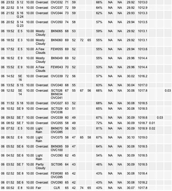
For starters the showers moving out of the I-39 corridor have a slightly more southern extent than POPs might indicate, but with cloud bases at 8000 ft and dewpoint depressions around 10 degrees along the southern edge, this area may see more sprinkles than accumulating rainfall. This activity should clear the area early this morning.
Attention then turns to the cluster of storms presently crossing from Nebraska into Iowa. Several CAMs are painting a surprisingly similar picture for this afternoon, maintaining this activity across Iowa and through…most likely…the southern portions of our CWA. We started with a dry forecast for this afternoon but made a late tweak to add a slight chance mention of thunderstorms for this area. There remains some skepticism that this cluster would be able to sustain itself and plow through the ridge, but if the timing is right, there may be some extra support from a weak warm front advancing north on the leading edge of better dewpoints.
The bigger concern for more widespread convection comes overnight as better low level moisture settles into the area while the upper ridge axis…which wasn`t all that stout to begin with…moves east of the area. An increasing low level jet and fairly steep midlevel lapse rates will further support convective development. Deep layer shear values may not be enough to support long lived discrete cells…but hail could be a concern with some of the stronger cores.
With ridging briefly becoming re-established and surface dewpoints in the mid 60s, the daytime hours for most of the area on Sunday look dry, warm, and noticeably more humid after the overnight activity moves out early. Areas south may see the first wave of showers and thunderstorms moving in late in the afternoon, but most of the activity would be expected Sunday evening and overnight into Monday.
Lenning/NWS Chicago
SATURDAY AFTERNOON
300 PM CDT Sat May 6 2023
.SHORT TERM… Issued at 247 PM CDT Sat May 6 2023
Through Sunday night…
Challenging forecast the next 36 hours as we get into somewhat of a “ring of fire”-esk pattern, more reminiscent of mid summer than early May. The result will be multiple chances of thunderstorms, some possibly severe, along with a threat of heavy rainfall. Unfortunately, timing and location of best precip and storm chances remains nebulous, tied to small, difficult to resolve waves and how they potentially get enhanced/altered by subsequent convection.
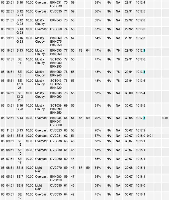
This afternoon, a small convective complex continues to dive south across downstate IL, riding the instability gradient safely away from our area. To our northwest, water vapor imagery shows a pair of vort maxes approaching the crest of the ridge axis across the northern Plains and into the Upper Mississippi Valley. Weak surface low associated with the lead wave was located over NE KS early this afternoon. This low will track to near GRB by 12z Sunday. As it does so, it should drag a convectively enhanced baroclinic zone north as a warm front. The very warm, seasonably humid, and moderately to strongly unstable air mass across the eastern Plains will spread east and northeast across our CWA tonight into Sunday.
A preponderance of the CAM guidance tonight suggests convection will affect our CWA. Details in how this convection develops and evolves is unclear, with a couple different plausible scenarios (or a combination of both) possible…
1) severe t-storms develop over IA late this afternoon and evening near northward advancing warm front, with these storms congealing into MCS and propagating into our CWA late this evening into the overnight hours with a continued potential for locally damaging winds and some instances of severe hail.
2) convection develops this evening over northern IL and/or southern WI as nocturnal low level jet develops and lifts parcels isentropically to their LFC where they can take advantage of the very steep lapses rates and moderately strong shear. In this scenario, the more intense storms would pose mainly a threat for hail with a much lower damaging wind threat.
Strong, pronounced EML across the region is providing for stee Plapse rates and enhancing instability, but also resulting in strong capping inversion for boundary layer parcels. Water vapor imagery early this afternoon shows a subtle shortwave moving across IA and MO now, likely aiding the down state MCS, but timing of this wave looks poor for CI along the warm front over IA later this afternoon and raises doubts about scenario one occurring.
That same subtle wave looks to be over western IL by early-mid evening, which could lend some support to elevated storms forming this evening (a la scenario 2) over our particularly eastern portions of our CWA.
Given the spread in guidance and strong EML, cannot completely discount the possibility of CI failing in IA later today and convection forming mainly east of our CWA this evening given the nose of the LLJ and max theta-e advection quickly shifts east of our CWA. For now, putting more stock in something like scenario 1 and 2 described above, but the potential failure mode has led me to keep pops no higher than likely tonight.
Any convection over our CWA late tonight should quickly exit stage right by early Sunday morning as LLJ further veers and weakens. Any convective cold pool left behind is likely to mix out and allow for a warm and humid day Sunday across most of the CWA, with strong cap expected to keep precip chance quite low.
Weak sfc low near GRB to start the day Sunday will track east across the lake into lower Michigan. The front associated with this low will begin to sag south during the day Sunday, however, the very cold (relative to air over land) marine layer should lake charge this cold front, allowing it to accelerate down the surge inland during the late afternoon. Temps right at the shore will drop into the 50s behind this “pneumonia front”, with the temp fall more muted with inland extent.
While confidence in the details is low, convectively undisturbed areas should see a large moderate to strongly unstable air mass develop upstream across the eastern Plains to the mid-Mississippi Valley Sunday. There is a pretty coherent signal in guidance that a shortwave trough will ripple east leading to intense convection developing over IA during the day Sunday. It seems likely that this convection will evolve into one or two MCSs that would then potentially track across or nearby our CWA Sunday night. This convection would pose a threat of both severe weather and heavy rainfall/flash flooding, but the details of where still it affects still need to be worked out. Certainly looks like the threat increases as you head west, but at this distance, the threat looks like it could extend east across our CWA.
– Izzi/NWS Chicago
