
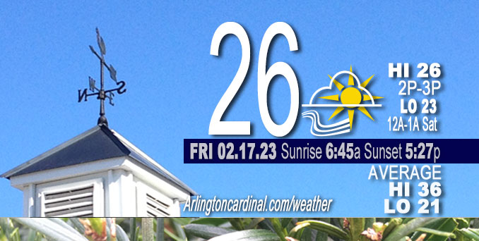
Friday Hi 26, mostly sunny, winds NNW to W to SW, 10 to 7 to 11 MPH, G18 to 13 to 25 MPH increasing Saturday, peaking to 31 MPH, 4a
NWS CHGO | NWS HRLY | /NWSchicago | 🌡
ARLINGTON HEIGHTS WEATHER
▴ forecast7 (Arl. Hts.) | RADAR | WIDE RADAR
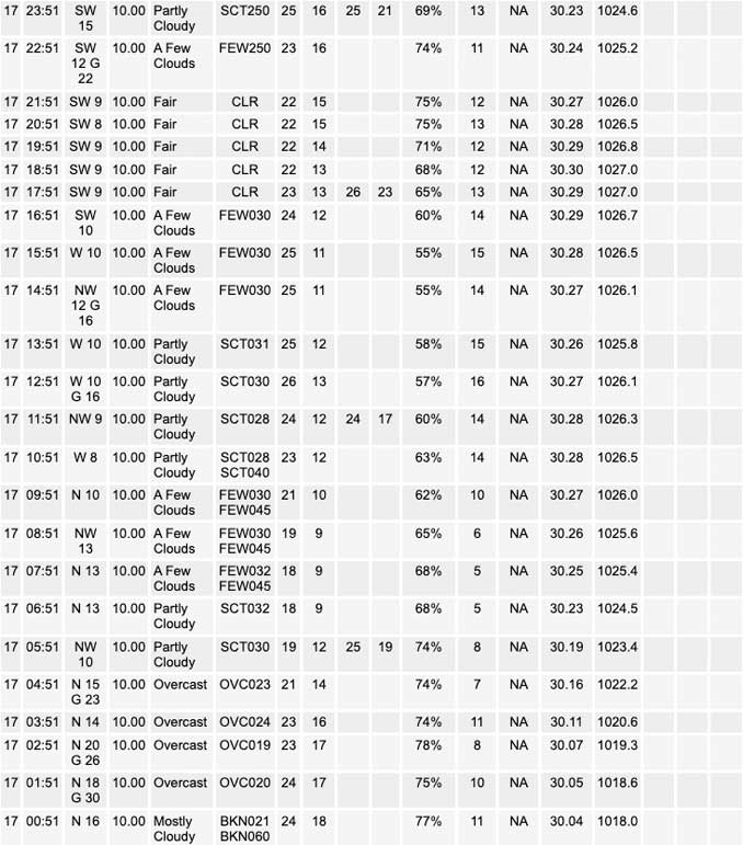
⏪ Hrly Data Table | Hrly Future Graph ⏩
IMPORTANT NOTE ON NWS DATA
⏪ Hrly Data Table | Hrly Future Graph ⏩
======================
Friday and Friday Evening …
Limited Snow Risk this morning in Northwest Indiana.
DISCUSSION…
Lake effect snow showers and travel impacts will linger this morning, especially across parts of Lake and Porter counties in northwestern Indiana.
The morning low was about 18°F, 6:00 a.m. to 8:00 a.m. Hi today only 26°F, but mostly sunny skies will help warmth when winds aren’t gusting or you’re protected from wind by structure. Expecting a warm-up into 40s on Saturday with the morning low occurring early (just after midnight) instead of the usual low occurring around dawn.
Daily low temperatures and daily high temperatures are on the way up. We’re gaining about 2 minutes of daylight every day in the progression toward vernal equinox, March 20, 2023. We gained 3 minutes of daylight on Friday, February 17, 2023.
======================
URGENT – WINTER WEATHER MESSAGE
National Weather Service Chicago IL
351 AM CST Thu Feb 16 2023
DuPage-Grundy-Northern Cook-Central Cook-Southern Cook- Northern Will-Southern Will-Eastern Will- Including the cities of Naperville, Wheaton, Downers Grove, Lombard, Carol Stream, Morris, Coal City, Minooka, Evanston, Des Plaines, Schaumburg, Palatine, Northbrook, Chicago, Cicero, Oak Lawn, Oak Park, La Grange, Calumet City, Oak Forest, Lemont, Orland Park, Park Forest, Joliet, Bolingbrook, Plainfield, Mokena, Channahon, Manhattan, Wilmington, Crete, Peotone, and Beecher 351 AM CST Thu Feb 16 2023
…WINTER WEATHER ADVISORY REMAINS IN EFFECT UNTIL 9 PM CST THIS EVENING…
* WHAT…Mixed precipitation expected. Total snow and sleet accumulations of 1 to 4 inches and ice accumulations of up to one tenth of an inch. Winds gusting as high as 40 mph, leading to blowing snow in exposed locations.
* WHERE…DuPage, Grundy, Cook, and Will counties.
* WHEN…From 6 AM to 9 PM CST today.
* IMPACTS…Plan on slippery road conditions. Areas of blowing snow could significantly reduce visibility. The hazardous conditions will likely impact the afternoon commute, and possibly the morning commute as well.
PRECAUTIONARY/PREPAREDNESS ACTIONS…
Slow down and use caution while traveling.
The latest road conditions for Illinois can be obtained on the internet at www.gettingaroundillinois.com.
O’HARE FORECAST …
Forecast Beginning Friday, Feb. 17, 2023
Friday: Sunny, with a high near 26. North northwest wind 5 to 10 mph becoming west southwest in the afternoon. Winds could gust as high as 15 mph.
Friday Night: Clear, with a temperature rising to around 26 by 5am. Southwest wind 5 to 15 mph, with gusts as high as 30 mph.
Saturday: Increasing clouds, with a high near 43. Southwest wind around 15 mph, with gusts as high as 30 mph.
Saturday Night: Mostly cloudy, with a low around 35. South southwest wind 10 to 15 mph, with gusts as high as 25 mph.
Sunday: Partly sunny, with a high near 47. South southwest wind around 15 mph, with gusts as high as 25 mph.
Sunday Night: Mostly cloudy, with a low around 29.
Washington’s Birthday: Partly sunny, with a high near 41.
Monday Night: Mostly cloudy, with a low around 33.
Tuesday: Partly sunny, with a high near 43.
Tuesday Night: A chance of rain and snow after midnight. Mostly cloudy, with a low around 31.
Wednesday: A chance of rain and snow. Mostly cloudy, with a high near 39.
Wednesday Night: Rain likely. Mostly cloudy, with a low around 33. Breezy.
Thursday: A chance of rain. Mostly cloudy, with a high near 46. Breezy.


CHICAGOWEATHERSTATION.COM

ChicagoWeatherStation.com I O’Hare Normal Temps/Precip I O’Hare Record Temps, Precip, Snow
LIVE RADAR | STORM TRACKS | UNISYS US IR SAT | UNISYS Midwest IR SAT | UNISYS More IR SAT
WunderMap® with Temperature/Wind Data || Google: Arlington Heights Area Temps | US TEMPS
Full Screen Motion Weather Radar (Wunderground.com)
Midwest Cloud Cover with Arlington Heights Weather Forecast
ChicagoWeatherStation.com I O’Hare Normal Temps/Precip I O’Hare Record Temps, Precip, Snow
SUNLIGHT DATA FOR SECURITY, TRAFFIC SAFETY, AND SPORTS
SunCalc.net data with solar azimuth and trajectory, times for dawn, sunrise, solar noon, sunset, dusk …
NIGHT SKY THIS MONTH …
Backyard stargazers get a monthly guide to the northern hemisphere’s skywatching events with “Tonight’s Sky.” Check the night sky objects for this month and past months in the playlist from the Space Telescope Science Institute YouTube channel (Musical track The Far River written by Jonn Serrie, from the album And the Stars Go With You courtesy of New World Music Ltd).
Get updates from The Cardinal ALL NEWS FEEDS on Facebook. Just ‘LIKE’ the ‘Arlington Cardinal Page (become a fan of our page). The updates cover all posts and sub-category posts from The Cardinal — Arlingtoncardinal.com. You can also limit feeds to specific categories. See all of The Cardinal Facebook fan pages at Arlingtoncardinal.com/about/facebook …
Help fund The Cardinal Arlingtoncardinal.com/sponsor
Area Forecast Discussion
National Weather Service Chicago/Romeoville, IL
521 AM CST Fri Feb 17 2023
.SHORT TERM… Issued at 324 AM CST Fri Feb 17 2023
Through Saturday…
Earlier snowfall has come to an end across northeastern Illinois with only a narrow band of lake effect snow continuing to impact Lake county and portions of far northern Newton county in Indiana this morning. Recent radar trends have shown some weakening of this band, however; the earlier progression of the band has slowed and even some signs of retrograding have been noted in the past hour. While forecast soundings continue to show marginal lake induced ELs (around 5000 to 6000 ft), there is strong synoptic ascent being observed through the depth of the saturated layer and into the base of the DGZ likely due to the presence of an upper-level vorticity maxima over northern Illinois and southern Wisconsin. This ascent in combination with the steep low-level lapse rates seems to be helping to compensate for the marginal lake effect parameters and allowing the lake effect snow band to persist. Furthermore, there has been some differences amongst the hi-res guidance as to the evolution of the band but the RAP model seems to be handling the evolution the best thus far especially with respect to the convergence axis.
If this continues to hold true, the RAP suggests that the convergence axis should remain centered over Lake county, IN through daybreak before gradually shifting eastward through the morning. As this occurs drier air is expected to be moving in which should allow the band to weaken as it exits the area later this morning. However, the expected prolonged duration of the snow looks to allow for additional accumulations across portions of Lake, IN and Porter counties on the order of 1 to 3 inches which could lead to snow covered roads and slowed travel for the morning commute. Given this potential I have extended the Winter Weather Advisory for these counties through 6 AM CST, but there is a chance that the advisory may need to be extended further if the aforementioned trends continue.
Otherwise, high pressure will be building into the area today which will continue to lighten winds and allow skies to clear out this afternoon. Unfortunately, the north-northwest winds will continue to advect in colder air which will keep high temperatures in the mid to upper 20s today despite the sunny skies. However, as the high slides through the area increasing southwesterly winds will develop across the region heading into Saturday which will warm temperatures into the low to mid-40s Saturday afternoon with gusts in the 25 to 30 mph range.
Yack/NWS Chicago
