
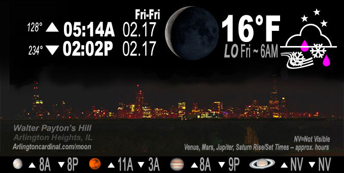
🌘 🌑 🌗 🌕 Waning Crescent Moon, sky cover overnight Thu. to Fri. 100% to 15%, winds NE to N to NW, 22 to 23 to 13 MPH, G36 to 39 to 20 MPH, Low 16, 6a to 8a
NWS CHGO | NWS HRLY | /NWSchicago | 🌡
ARLINGTON HEIGHTS WEATHER
▴ forecast7 (Arl. Hts.) | RADAR | WIDE RADAR
IMPORTANT NOTE ON NWS DATA
======================
NIGHT FORECASTS …
NOTE: Keep in mind lunar rise and set times don’t always correspond with night weather and early morning lows because on some days during the month the moon is visible in the sky predominantly during the daytime hours.
Overnight Thursday/Friday …
Weather Hazards expected …
Winter Weather Advisory
Hazardous Weather Outlook
Lakeshore Flood Advisory
Period of light freezing rain or freezing drizzle through early evening becoming more probable for areas along and north of I-80 that are below freezing; some uncertainty on how treated, wet roads will respond
Period of evening snow, possibly briefly heavy along/north of I-88, moving from west to east across the area with additional minor accumulations
Northerly winds gusting 30 to 40 mph this evening with highest gusts closer to the lake
Likely some lake effect snow late this evening and overnight, and for northwest Indiana into Friday morning, but low confidence on how much for additional accumulations and impacts with the lake effect snow
DISCUSSION…
The synoptic snow shield looks to depart by or just after midnight, but lingering lake effect snow is probable.
Hello mobile users! If you encounter mobile “unfriendly” weather page, turn your phone sideways for a better view.
======================
O’HARE FORECAST …
Forecast Beginning Thursday Night, Feb. 16, 2023 …
Thursday Night: Snow and freezing rain, possibly mixed with sleet before 1am, then a slight chance of snow between 1am and 4am. Patchy blowing snow between 7pm and 1am. Low around 16. Blustery, with a north wind 15 to 25 mph, with gusts as high as 40 mph. Chance of precipitation is 100%. Little or no ice accumulation expected. New snow and sleet accumulation of 1 to 2 inches possible.
Friday: Sunny, with a high near 27. North northwest wind 10 to 15 mph, with gusts as high as 20 mph.
Friday Night: Mostly clear, with a low around 19. Breezy, with a southwest wind 10 to 20 mph, with gusts as high as 30 mph.
Saturday: Sunny, with a high near 40. Breezy, with a southwest wind 15 to 20 mph, with gusts as high as 30 mph.
Saturday Night: Mostly cloudy, with a low around 33.
Sunday: Partly sunny, with a high near 46.
Sunday Night: Mostly cloudy, with a low around 30.
Washington’s Birthday: Partly sunny, with a high near 42.
Monday Night: Mostly cloudy, with a low around 32.
Tuesday: A chance of rain and snow. Mostly cloudy, with a high near 42.
Tuesday Night: A chance of rain and snow. Mostly cloudy, with a low around 27.
Wednesday: A chance of snow. Partly sunny, with a high near 36.
O’Hare forecast archive and hourly weather observations archive are available HERE on the CARDINAL NEWS Magazine.
Arlingtoncardinal.com/moonphases
Arlingtoncardinal.com/nightsky
NIGHT SKY THIS MONTH …
Check the night sky objects for this month and past months in the playlist from the Space Telescope Science Institute YouTube channel Backyard stargazers get a monthly guide to the northern hemisphere’s skywatching events with “Tonight’s Sky” (Musical track The Far River written by Jonn Serrie, from the album And the Stars Go With You courtesy of New World Music Ltd. Musical track The Far River written by Jonn Serrie, from the album And the Stars Go With You courtesy of New World Music Ltd).
Telephoto lens, ISO 100, f/11, Shutter Speed 1/100 to 1/125 for the Moon.
Get updates from The Cardinal ALL NEWS FEEDS on Facebook. Just ‘LIKE’ the ‘Arlington Cardinal Page (become a fan of our page). The updates cover all posts and sub-category posts from The Cardinal — Arlingtoncardinal.com. You can also limit feeds to specific categories. See all of The Cardinal Facebook fan pages at Arlingtoncardinal.com/about/facebook …
Help fund The Cardinal Arlingtoncardinal.com/sponsor
Telephoto lens, ISO 1600, f/11, Shutter Speed 2.5″ for the skyline. The skyline exposure was toned down, and brightness and contrast was adjusted in Photoshop.
Area Forecast Discussion
National Weather Service Chicago/Romeoville, IL
919 PM CST Thu Feb 16 2023
.UPDATE… Issued at 919 PM CST Thu Feb 16 2023
Earlier fast eastward motion of the long-lived deformation area snow has slowed this evening. As a result, some of the worst conditions in southern portions of the advisory are occurring at this time. While the current moderate to heavy snow in the band will only last an hour or so longer in any given location, felt it was prudent to extend the advisory from LaSalle County and points east in northern Illinois that were set to expire at 9 PM. In addition, with heavy snow over southeast McHenry County, opted to extend the warning there until 12 AM, which is when Lake County Illinois is set to expire.
There has been multi-cellular lake effect snow into northeast Illinois and northwest Indiana, despite fairly marginal thermodynamics. These thermodynamics will improve some overnight, with CAMs favoring development of a single band after the synoptic snow ends (and signs on the terminal Dopplers of that single band development already taking place). Wind direction trends west of the lake suggest the likely single LES band will be fairly progressive, though still uncertainty on exact residence time into eastern Cook County and then northwest Indiana. For this reason, maintained the planned 12 AM advisory end time for Cook County zones, and 4 AM for Lake and Porter Indiana, to allow the midnight shift to assess trends. Assuming lake induced convergence axis remains transient, expect LES accumulations up to 2″.
Given air temperatures in the 20s to around 30 and dropping from here, any untreated or unplowed roads can be expected to remain hazardous through the overnight. Freezing of lingering moisture on roads will likely result in some icy spots. Blustery northerly winds will cause patchy blowing and drifting snow in open areas, and west to east roads will be the most susceptible to impacts.
Castro/NWS Chicago
&&
.SHORT TERM… Issued at 308 PM CST Thu Feb 16 2023
Through Friday night…
Key messages:
* Period of light freezing rain or freezing drizzle through early evening becoming more probable for areas along and north of I-80 that are below freezing; some uncertainty on how treated, wet roads will respond
* Period of evening snow, possibly briefly heavy along/north of I-88, moving from west to east across the area with additional minor accumulations
* Northerly winds gusting 30 to 40 mph this evening with highest gusts closer to the lake
* Likely some lake effect snow late this evening and overnight, and for northwest Indiana into Friday morning, but low confidence on how much for additional accumulations and impacts with this
The now more neutrally-tilted upper trough is across central Iowa as of 3 PM with a 110 kt 500 mb jet ahead of this escorting a dry slot into the forecast area. This loss of mid-level moisture has been enough to significantly cut down shower coverage and even snow coverage in the far north. Radar and spotty mPING observations indicate that at least patchy drizzle/spotty light rain is present under this dry slot and likely to continue over the area into early evening. The 32F isotherm is draped from the north side of Chicago through LaSalle-Peru and inching ever so gradually southward. This trend will continue into this evening, and so the freezing drizzle/light freezing rain threat is expected to encompass areas along and north of I-80 into early evening, and for far northwest Indiana starting early evening. Confidence for the Advisory expansion for Lake and Porter in northwest Indiana was admittedly not the highest, but did have 3-4 hours of freezing precipitation forecast in out forecast only 4-5 hours from present, so had to make a decision and leaned that route with 33-34F temperatures in those counties likely to dip.
There is an outcome that this drizzle into the evening commute could be of notably high impact where it is 32F or less. The gusty winds can help with ice accretion which is one reason. While some icy roads are probable, that higher end impact (widespread iciness including main roads) may be an outlier solution because roads are wet and many treated, as well as pavement temperatures (especially in the metro) being slightly above freezing. But nonetheless, will have to watch this carefully, and ensure active messaging if the freezing drizzle becomes a bigger problem.
The remarkably persistent deformation-enhanced snow area that has crossed Iowa today is expected to move east into the area along and immediately behind the 850 mb low center. The number and duration of 1/4 mile observations in Iowa with this has eased, but still plenty of 1/2 SM and widespread 35+ dBZ within this snow zone. So we are expecting a moderate intensity snow with this, especially along and north of I-80, that would last between an hour and a half to three hours. This looks to be ~8-11 PM in Chicago, and so felt comfortable extending the Advisory for the lakeside counties. Also during that time, northerly winds will be gusting 30 to 40 mph, and so those locations that are open and have had snow may start to see some shallow blowing, helped by increasing snow-to-liquid ratios of the falling snow.
For northern locations within the Winter Storm Warning, snow accumulation will and already has had a sharp gradient. Amounts with 5+ inches are looking more likely to be confined to the far north near the Wisconsin state line in those counties.
The synoptic snow shield looks to depart by or just after midnight, but lingering lake effect snow is probable. How robust this is is somewhat uncertain, although ingredients are not screaming a high impact, heavy lake effect band. The lake-induced equilibrium levels are forecast to reach between 5 and 6 kft, with the top portions of those within the DGZ. That has been a consistent signal. Slightly better today has been the forecast of near lakeshore convergence from the convection-allowing models (CAMs). That probably tips the scale that there will be lake effect snow at least immediately along the shore as well as some into northwest Indiana continuing after daybreak Friday, but of how much additional accumulation is low confidence. We do have 0.5 to 2 inches forecast of lake effect snow.
Friday largely looks quiet with clearing from west to east through the morning into early afternoon. Highs will be below normal by around 10 degrees north of I-80. Diminishing winds with the high passing overhead in the afternoon may allow for temperatures to drop sharply early evening, but then return flow should prompt a gradual temperature rise the rest of Friday night.
MTF/NWS Chicago
