
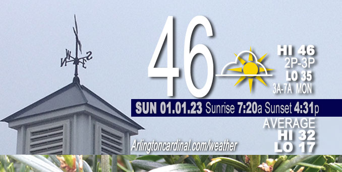
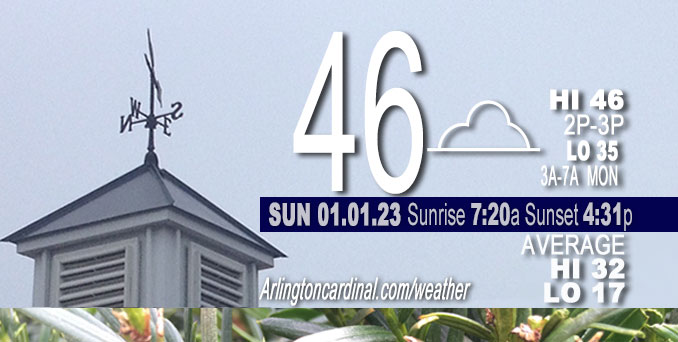
Sunday Hi 46, mostly cloudy, winds SW to W to WNW, 7 to 2 MPH
NWS CHGO | NWS HRLY | /NWSchicago | 🌡
ARLINGTON HEIGHTS WEATHER
▴ forecast7 (Arl. Hts.) | RADAR | WIDE RADAR
⏪ Hrly Data Table | Hrly Future Graph ⏩
IMPORTANT NOTE ON NWS DATA
⏪ Hrly Data Table | Hrly Future Graph ⏩
======================
Sunday and Sunday Night …
Weather Hazards expected…
Elevated Fog Risk dissipating mid- to late-morning Sunday. Fog may develop again Sunday night and overnight.
DISCUSSION…
Areas of fog, some locally dense, will gradually fade during the mid- to late Sunday morning. Fog may redevelop again late Sunday evening and overnight, some of which again may be dense. Wind will shift to easterly overnight after about 2:00 a.m. Mild period coming the next few days. The high temperature for Tuesday has trended upward with a high of 61°F.
Hello mobile users! If you encounter a mobile “unfriendly” weather page, turn your phone sideways for a better view.
======================
O’HARE FORECAST …
Forecast Beginning Sunday, Jan. 01, 2023
New Year’s Day: Patchy fog before noon. Otherwise, cloudy, with a high near 46. West wind around 5 mph, with gusts as high as 15 mph.
Sunday Night: Cloudy, with a low around 34. West southwest wind around 5 mph becoming calm in the evening.
Monday: A 20 percent chance of rain after noon. Cloudy, with a high near 44. East northeast wind 5 to 10 mph.
Monday Night: Rain, with thunderstorms also possible after midnight. Low around 39. East northeast wind 10 to 15 mph becoming south after midnight. Winds could gust as high as 25 mph. Chance of precipitation is 100%.
Tuesday: A 40 percent chance of rain, mainly before noon. Partly sunny, with a high near 61. Southwest wind around 15 mph, with gusts as high as 30 mph.
Tuesday Night: A 20 percent chance of rain before midnight. Mostly cloudy, with a low around 34.
Wednesday: A chance of rain and snow, mainly after noon. Cloudy, with a high near 37. Chance of precipitation is 40%.
Wednesday Night: A chance of snow before midnight. Mostly cloudy, with a low around 26.
Thursday: Partly sunny, with a high near 31.
Thursday Night: Partly cloudy, with a low around 23.
Friday: Mostly sunny, with a high near 35.
Friday Night: Mostly cloudy, with a low around 28.
Saturday: A chance of rain. Mostly cloudy, with a high near 40.


CHICAGOWEATHERSTATION.COM

ChicagoWeatherStation.com I O’Hare Normal Temps/Precip I O’Hare Record Temps, Precip, Snow
LIVE RADAR | STORM TRACKS | UNISYS US IR SAT | UNISYS Midwest IR SAT | UNISYS More IR SAT
WunderMap® with Temperature/Wind Data || Google: Arlington Heights Area Temps | US TEMPS
Full Screen Motion Weather Radar (Wunderground.com)
Midwest Cloud Cover with Arlington Heights Weather Forecast
ChicagoWeatherStation.com I O’Hare Normal Temps/Precip I O’Hare Record Temps, Precip, Snow
SUNLIGHT DATA FOR SECURITY, TRAFFIC SAFETY, AND SPORTS
SunCalc.net data with solar azimuth and trajectory, times for dawn, sunrise, solar noon, sunset, dusk …
NIGHT SKY THIS MONTH …
Backyard stargazers get a monthly guide to the northern hemisphere’s skywatching events with “Tonight’s Sky.” Check the night sky objects for this month and past months in the playlist from the Space Telescope Science Institute YouTube channel (Musical track The Far River written by Jonn Serrie, from the album And the Stars Go With You courtesy of New World Music Ltd).
Get updates from The Cardinal ALL NEWS FEEDS on Facebook. Just ‘LIKE’ the ‘Arlington Cardinal Page (become a fan of our page). The updates cover all posts and sub-category posts from The Cardinal — Arlingtoncardinal.com. You can also limit feeds to specific categories. See all of The Cardinal Facebook fan pages at Arlingtoncardinal.com/about/facebook …
Help fund The Cardinal Arlingtoncardinal.com/sponsor
Area Forecast Discussion
National Weather Service Chicago/Romeoville, IL
528 AM CST Sun Jan 1 2023
.SHORT TERM… Issued at 320 AM CST Sun Jan 1 2023
Through Monday…
Key Messages:
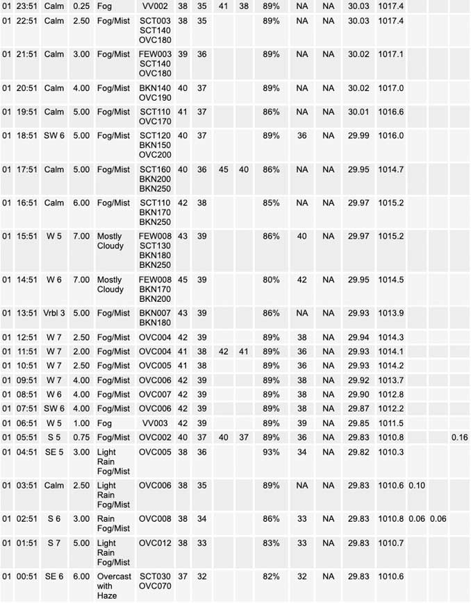
* Rain ending toward daybreak with lingering fog through the AM
* Chance for fog again late tonight into Monday AM, with spotty drizzle/light rain possible Monday PM ahead of next system
Rain continues in areas along and north of I-80 with the back edge having shifted east of I-39. This will continue to progress eastward with time early this morning with most areas expected to be dry toward daybreak. While fog is not currently dense (1-3 SM), there will be continued visibility reductions in fog into the morning hours, likely expanding in coverage some in the wake of the showers. Tough to say how low the visibility ends up with model guidance continuing to hit the fog hard, especially along and southeast of I-55 into northwest Indiana. Currently no plans for a Dense Fog Advisory, though patchy dense fog certainly cannot be ruled out. Will also be keeping an eye on developing fog across northeast Iowa and see if it tries to slosh eastward and expand in coverage into northwest Illinois.
As for the rest of the day, given the lingering low clouds and fog through the morning and light winds reducing the amount of warm advection taking place, temperatures likely remain below 50, with lower 40s north and upper 40s to near 50 south.
Winds flop over to easterly late tonight in response to the developing lee cyclone in the south central Plains. There are hints of weak low-mid level frontogenesis in some model guidance across the far southern forecast area (south of Kankakee River) late tonight that tries to squeeze out a hundredth or two of QPF. Think this likely remains virga to maybe a few sprinkles if it were to develop. The focus instead will be on the potential for another round of foggy conditions late tonight through Monday morning. Heading into the afternoon there is a signal for increasing low-level moisture which could support patchy drizzle or spotty light rain lifting across the area in advance of the eventual warm front and more widespread soaking rain with our next weather system which is discussed in more detail in the long term section below.
The noted easterly winds will bring cooler air into northeast Illinois off of Lake Michigan on Monday. This will hold down temperatures generally along and north of I-80 through the day, which could struggle to reach 40. Upper 40s to mid 50s are expected south of there.
Petr/NWS Chicago
