
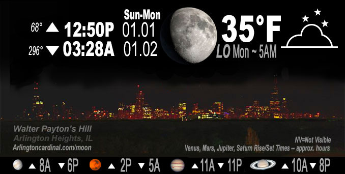
🌔 🌕 🌗 🌑 Waxing Gibbous Moon, sky cover overnight Sun. to Mon. 93% to 78% to 91% to 76%, winds WSW to SW to NW to NE, 6 to 2 to 5 MPH, Low 35, 5a to 6a
NWS CHGO | NWS HRLY | /NWSchicago | 🌡
ARLINGTON HEIGHTS WEATHER
▴ forecast7 (Arl. Hts.) | RADAR | WIDE RADAR
IMPORTANT NOTE ON NWS DATA
======================
NIGHT FORECASTS …
NOTE 1: Forecast and information text below may refer to a previous night on Arlingtoncardinal.com, and might not be updated until late afternoon, evening, or overnight. However, Night Sky archives on CARDINAL NEWS Magazine include text forecasts that correspond to the lunar phase graphic above.
NOTE 2: Keep in mind lunar rise and set times don’t always correspond with night weather and early morning lows because on some days during the month the moon is visible in the sky predominantly during the daytime hours.
Overnight Sunday/Monday …
Weather Hazards expected …
Limited Fog Risk overnight toward morning.
DISCUSSION…
Widespread fog is expected to develop Sunday evening and to Sunday night with some areas of dense fog anticipated, particularly south of I-80. This fog will likely persist through much of Monday morning, if not extend even further into the day.
Hello mobile users! If you encounter mobile “unfriendly” weather page, turn your phone sideways for a better view.
======================
O’HARE FORECAST …
Forecast Beginning Sunday Night, Jan. 01, 2023 …
Sunday Night: Isolated sprinkles before 8pm. Patchy fog after midnight. Otherwise, mostly cloudy, with a low around 34. Southwest wind around 5 mph becoming calm in the evening.
Monday: A 20 percent chance of rain after noon. Patchy fog before noon. Otherwise, cloudy, with a high near 42. East northeast wind 5 to 10 mph.
Monday Night: Rain, with thunderstorms also possible after midnight. Temperature rising to around 49 by 5am. East northeast wind 5 to 10 mph becoming southeast after midnight. Winds could gust as high as 15 mph. Chance of precipitation is 100%. New rainfall amounts between a half and three quarters of an inch possible.
Tuesday: A 30 percent chance of rain and thunderstorms before noon. Cloudy, then gradually becoming mostly sunny, with a high near 61. South southeast wind 10 to 15 mph becoming southwest in the afternoon. Winds could gust as high as 30 mph.
Tuesday Night: Mostly cloudy, with a low around 35. West southwest wind 10 to 15 mph, with gusts as high as 20 mph.
Wednesday: A chance of rain and snow, mainly after noon. Cloudy, with a high near 37. Chance of precipitation is 40%.
Wednesday Night: A 40 percent chance of snow. Cloudy, with a low around 26.
Thursday: Mostly cloudy, with a high near 31.
Thursday Night: Partly cloudy, with a low around 22.
Friday: Mostly sunny, with a high near 33.
Friday Night: Mostly cloudy, with a low around 28.
Saturday: Partly sunny, with a high near 38.
Saturday Night: Mostly cloudy, with a low around 31.
Sunday: Partly sunny, with a high near 39.
O’Hare forecast archive and hourly weather observations archive are available HERE on the CARDINAL NEWS Magazine.
Arlingtoncardinal.com/moonphases
Arlingtoncardinal.com/nightsky
NIGHT SKY THIS MONTH …
Check the night sky objects for this month and past months in the playlist from the Space Telescope Science Institute YouTube channel Backyard stargazers get a monthly guide to the northern hemisphere’s skywatching events with “Tonight’s Sky” (Musical track The Far River written by Jonn Serrie, from the album And the Stars Go With You courtesy of New World Music Ltd. Musical track The Far River written by Jonn Serrie, from the album And the Stars Go With You courtesy of New World Music Ltd).
Telephoto lens, ISO 100, f/11, Shutter Speed 1/100 to 1/125 for the Moon.
Get updates from The Cardinal ALL NEWS FEEDS on Facebook. Just ‘LIKE’ the ‘Arlington Cardinal Page (become a fan of our page). The updates cover all posts and sub-category posts from The Cardinal — Arlingtoncardinal.com. You can also limit feeds to specific categories. See all of The Cardinal Facebook fan pages at Arlingtoncardinal.com/about/facebook …
Help fund The Cardinal Arlingtoncardinal.com/sponsor
Telephoto lens, ISO 1600, f/11, Shutter Speed 2.5″ for the skyline. The skyline exposure was toned down, and brightness and contrast was adjusted in Photoshop.
Area Forecast Discussion
National Weather Service Chicago/Romeoville, IL
254 PM CST Sun Jan 1 2023
.SHORT TERM… Issued at 253 PM CST Sun Jan 1 2023
Through Monday night…
Temperatures this evening and overnight will be rather steady thanks to some modest low level WAA and low ceilings in anticipation of the approaching storm system. Meanwhile, a potent, quasi-stationary warm front will be hanging out in central IL tonight before trekking northward into the area on Monday. Lows Monday morning will bottom out near freezing across some of Illinois` northern-most counties while the far southern CWA nearer to the front will hang in the lower 40s. Mid-afternoon temperatures will reach the 40s and lower 50s on Monday. Though once the front begins its progression through the area Monday evening and night, conditions will steadily warm behind it. Some spots in far south may not even drop below 50 before they begin warming through the night eventually tapping into the 60s by Tuesday morning. Areas further north, primarily north of I-90, will be allowed to cool back into the upper 30s prior to the arrival of the front Monday night. However, these areas too will warm overnight with the whole CWA expected to be in the 50s by mid- morning on Tuesday.
Meanwhile, areas of dense fog this morning have thinned out across the area, though not completely dissipated. Several spots are still reporting visibilities under 5 miles as of 2PM. This isn`t expected to improve much through the remainder of the day before conditions are expected to worsen tonight. With dewpoints sitting in the upper 30s and lower 40s this afternoon, areas of dense fog are anticipated to redevelop as we cool down into the 30s this evening and overnight. The greatest potential for widespread, dense fog is across and south of the Kankakee River valley where they may see some limited moisture advection take place overnight. Through the day tomorrow, fog may stick around or redevelop across areas along and south of the front as we begin to see that influx of low level moisture.
As far as the rain expectations go, there have been a few notable changes among guidance since yesterday`s runs. However, the most notable would be the drop in coverage and overall intensity and a resultant drop in QPF. Best guess as to why this is would be the shift in the track of the LLJ to the southeast. The LLJ was previously expected to just graze the CWA to the southeast, but models are now showing it even further displaced from us now moving through central and southeast Indiana and the higher QPF has followed suit. The NAM keeps the LLJ a bit more local leading to higher QPF, though it has certainly become an outlier among models. The LLJ has also taken some of the moisture with it, though PWAT values are still shown to exceed one inch across just about the whole CWA. As high-res and convective allowing models are now reaching into the brunt of this storm, simulated reflectivity shows the rain coverage may not be quite as widespread as previously thought, or at least the window for truly widespread rain has tightened now that we`ve removed some of our moisture and forcing. Nonetheless, a healthy amount of rain remains in the forecast through Tuesday morning. Latest QPF among guidance shows most of the area receiving roughly 0.5-0.8″ of rain. Models and ensemble members with widespread 1″+ totals have become few and far between.
Though QPF has dropped a bit, thunder chances are kept alive by the ample low level instability still in play. Not a whole lot has changed on the thunder front, in fact, with about 200-400 J/kg of MUCAPE still expected across most of the area, the higher end of that expected further south in the CWA. Some decent low level shear also presents a low, but non-zero, threat for a couple of strong thunderstorms, with damaging winds being the primary concern. The strong storm threat is mainly a concern south of I-80 where the greatest instability and stronger low level flow can be found. At this point, at least a couple of light, embedded thunderstorms in this area appear probable. The most favorable time for thunderstorms lines up with the expected timeframe of the heavier and most widespread rainfall: roughly the six hour period between 10PM and 4AM. The soaking rain overnight will likely be followed by some scattered showers through much of Tuesday morning with a slight chance for a light thunderstorm or two hanging on into the morning as well.
Doom/NWS Chicago
