
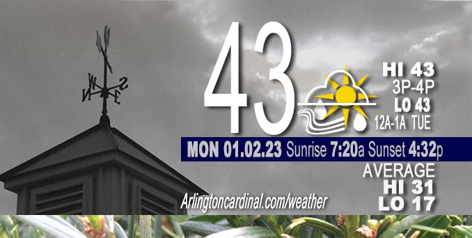
Monday Hi 43, mostly cloudy, rain starts 6p, winds NE, Calm 7 to 9 MPH, G13 to 14 MPH starting 5p
NWS CHGO | NWS HRLY | /NWSchicago | 🌡
ARLINGTON HEIGHTS WEATHER
▴ forecast7 (Arl. Hts.) | RADAR | WIDE RADAR
⏪ Hrly Data Table | Hrly Future Graph ⏩
IMPORTANT NOTE ON NWS DATA
⏪ Hrly Data Table | Hrly Future Graph ⏩
======================
Monday and Monday Night …
Weather Hazards expected…
Significant Fog Risk.
Limited Thunderstorm Risk tonight (Slight chance of thunderstorms near Arlington Heights after 2:00 a.m.)
DISCUSSION…
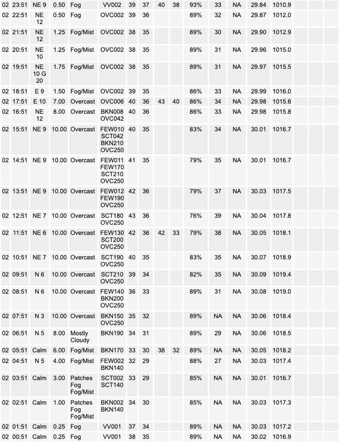
Areas of dense fog will Monday morning with a gradual dissipation in coverage. However, some fog is likely to persist into or redevelop this Monday afternoon and evening.
Rainfall overnight may be heavy at times. The Arlington Heights area forecast is between one-half inch and three-quarters inch between 1:00 a.m. and 10:00 a.m. Tuesday. In addition, embedded thunderstorms are possible late tonight. A couple of these may be strong south of the Kankakee River Valley.
The high temperature forecast for Tuesday has trended back down from a high of 61°F to high 59°F.
Hello mobile users! If you encounter a mobile “unfriendly” weather page, turn your phone sideways for a better view.
======================
O’HARE FORECAST …
Forecast Beginning Monday, Jan. 02, 2023
Monday: A slight chance of drizzle after 5pm. Patchy fog before 4pm. Otherwise, cloudy, with a high near 43. East northeast wind 5 to 10 mph.
Monday Night: Rain, with thunderstorms also possible after 4am. Patchy fog after 7pm. Temperature falling to near 41 by 8pm, then rising to around 45 during the remainder of the night. East northeast wind around 10 mph, with gusts as high as 15 mph. Chance of precipitation is 100%. New rainfall amounts between a half and three quarters of an inch possible.
Tuesday: Rain and thunderstorms before 10am, then a slight chance of rain between 10am and 1pm. Patchy fog before 11am. High near 60. East wind around 10 mph becoming southwest in the afternoon. Winds could gust as high as 20 mph. Chance of precipitation is 100%. New precipitation amounts between a tenth and quarter of an inch, except higher amounts possible in thunderstorms.
Tuesday Night: Mostly cloudy, with a low around 36. Southwest wind around 10 mph.
Wednesday: A 30 percent chance of rain after 1pm. Mostly cloudy, with a high near 39. West southwest wind around 10 mph, with gusts as high as 20 mph.
Wednesday Night: A chance of rain before 7pm, then a chance of rain and snow between 7pm and 10pm, then a chance of snow after 10pm. Cloudy, with a low around 30. Chance of precipitation is 40%.
Thursday: A 40 percent chance of snow before 1pm. Mostly cloudy, with a high near 34.
Thursday Night: Mostly cloudy, with a low around 24.
Friday: Mostly sunny, with a high near 33.
Friday Night: Mostly cloudy, with a low around 27.
Saturday: A chance of snow. Partly sunny, with a high near 37.
Saturday Night: A chance of snow. Mostly cloudy, with a low around 31.
Sunday: Mostly cloudy, with a high near 37.


CHICAGOWEATHERSTATION.COM

ChicagoWeatherStation.com I O’Hare Normal Temps/Precip I O’Hare Record Temps, Precip, Snow
LIVE RADAR | STORM TRACKS | UNISYS US IR SAT | UNISYS Midwest IR SAT | UNISYS More IR SAT
WunderMap® with Temperature/Wind Data || Google: Arlington Heights Area Temps | US TEMPS
Full Screen Motion Weather Radar (Wunderground.com)
Midwest Cloud Cover with Arlington Heights Weather Forecast
ChicagoWeatherStation.com I O’Hare Normal Temps/Precip I O’Hare Record Temps, Precip, Snow
SUNLIGHT DATA FOR SECURITY, TRAFFIC SAFETY, AND SPORTS
SunCalc.net data with solar azimuth and trajectory, times for dawn, sunrise, solar noon, sunset, dusk …
NIGHT SKY THIS MONTH …
Backyard stargazers get a monthly guide to the northern hemisphere’s skywatching events with “Tonight’s Sky.” Check the night sky objects for this month and past months in the playlist from the Space Telescope Science Institute YouTube channel (Musical track The Far River written by Jonn Serrie, from the album And the Stars Go With You courtesy of New World Music Ltd).
Get updates from The Cardinal ALL NEWS FEEDS on Facebook. Just ‘LIKE’ the ‘Arlington Cardinal Page (become a fan of our page). The updates cover all posts and sub-category posts from The Cardinal — Arlingtoncardinal.com. You can also limit feeds to specific categories. See all of The Cardinal Facebook fan pages at Arlingtoncardinal.com/about/facebook …
Help fund The Cardinal Arlingtoncardinal.com/sponsor
Area Forecast Discussion
National Weather Service Chicago/Romeoville, IL
1016 AM CST Mon Jan 2 2023
.UPDATE… Issued at 1016 AM CST Mon Jan 2 2023
Dense fog continues across northwestern Indiana and parts of central Illinois this morning ahead of a developing warm front that is currently draped across the Ohio River Valley. Ahead of this boundary dew points have climbed into the mid to upper 30s and lower 40s in spots which has created a saturated lower atmosphere and lead to the widespread fog being observed this morning. Recent trends have started to show some improvement across portions of northeastern and central Illinois, but northwest Indiana continues to show several areas with visibilities less than a mile. While the dense fog is expected to lift this afternoon as the warm front develops and starts to move northward some patchy fog may persist through this evening. For now the Dense Fog Advisory has been extended through noon central time for areas east of I-55 and northwestern Indiana to account for this potential so be sure to use caution when traveling this morning.
As the aforementioned warm front lifts northward later today, spotty drizzle continues to look possible ahead of the front this afternoon and evening which may lead to some reduced visibilities and slowed evening commute. Better rain chance will move in with the front late evening and persist through the overnight hours with the potential for some isolated embedded thunderstorms as well. Forecast soundings continue to show marginal elevated instability developing this evening which should be enough to get a couple rumbles of thunder, but the severe potential with any of these storms tonight continues to look very low. However, the high precipitable water values (especially for this time of year) will make for some soaking rainfall tonight into the day on Tuesday. The going forecast accounts for all of this potential well so no changes were made for this mornings updates.
Yack/NWS Chicago
