
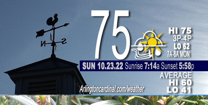
SUNDAY Hi 75°F, partly cloudy becoming partly sunny, chance of showers and thunderstorms after 7p, winds SSE to S, 16 to 22 to 18 MPH, G24 to 36 to 30 MPH
NWS CHGO | NWS HRLY | /NWSchicago | 🌡
ARLINGTON HEIGHTS WEATHER
▴ forecast7 (Arl. Hts.) | RADAR | WIDE RADAR
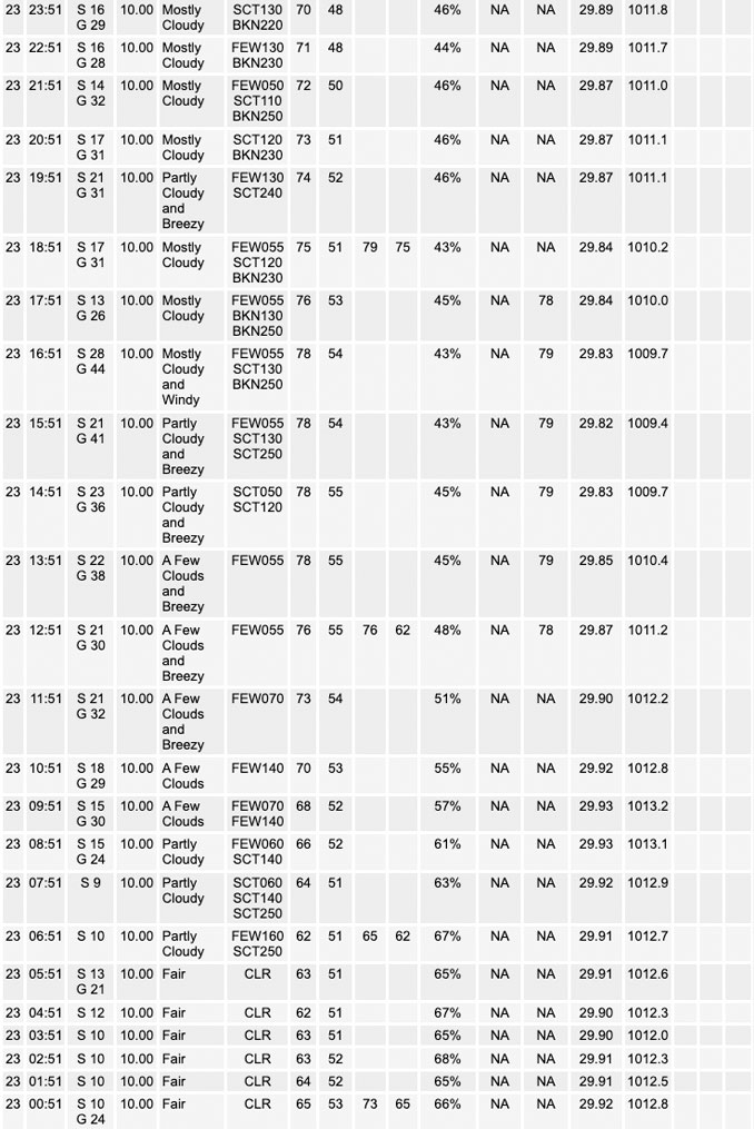
⏪ Hrly Data Table | Hrly Future Graph ⏩
IMPORTANT NOTE ON NWS DATA
⏪ Hrly Data Table | Hrly Future Graph ⏩
======================
No watches or warnings issued near O’Hare at 9:00 a.m. Sunday.
Updates at Arlingtoncardinal.com/NWSChicago
Chicagoland Weather hazards expected…
Wildfire risk is elevated in Chicagoland, but no Red Flag Warnings were activated in Northern Illinois as of 9:20 AM.
Special Weather Statement
National Weather Service Chicago/Romeoville IL
437 AM CDT Sun Oct 23 2022
Chicagoland …
…ELEVATED RISK FOR BRUSH FIRE SPREAD THIS AFTERNOON…
The combination of gusty southerly winds around 35 mph, possibly higher, and very dry ground conditions will create an elevated risk for brush and grass fire spread this afternoon.
Any planned burning should be postponed and care should be taken when disposing of any smoking materials.
Hazardous Weather Outlook
National Weather Service Chicago/Romeoville IL
409 AM CDT Sun Oct 23 2022
Winnebago-Boone-McHenry-Lake IL-Ogle-Lee-De Kalb-Kane-DuPage- La Salle-Kendall-Grundy-Kankakee-Livingston-Iroquois-Ford- Northern Cook-Central Cook-Southern Cook-Northern Will- Southern Will-Eastern Will-Lake IN-Porter-Newton-Jasper-Benton- 409 AM CDT Sun Oct 23 2022 /509 AM EDT Sun Oct 23 2022/
This Hazardous Weather Outlook is for portions of North Central Illinois…Northeast Illinois and Northwest Indiana.
Sunday and Sunday Night.
Weather hazards expected…
Elevated Fire Weather Risk.
Limited Non Thunderstorm Wind Risk.
Limited Thunderstorm Risk tonight.
DISCUSSION…
Gusty winds around 35 mph, possibly higher, and very dry conditions will lead to an elevated risk of brush fire spread this afternoon. Postpone any planned burning and be careful when disposing of smoking materials.
Showers and isolated thunderstorms are expected to develop this evening, with thunderstorm chances mainly along and west of I-55.
Hello mobile users! If you encounter mobile “unfriendly” weather page, turn your phone sideways for a better view.
======================
O’HARE FORECAST …
Forecast Beginning Sunday, Oct. 23, 2022
Sunday: Mostly sunny, with a high near 75. Breezy, with a south wind 15 to 20 mph, with gusts as high as 35 mph.
Sunday Night: A chance of showers and thunderstorms. Mostly cloudy, with a low around 62. Breezy, with a south wind 15 to 20 mph, with gusts as high as 30 mph. Chance of precipitation is 30%.
Monday: Mostly cloudy, with a high near 74. Breezy, with a south wind 15 to 20 mph, with gusts as high as 30 mph.
Monday Night: Showers likely, mainly after 1am. Cloudy, with a low around 58. South wind 10 to 15 mph, with gusts as high as 30 mph. Chance of precipitation is 70%.
Tuesday: Showers. High near 62. South southwest wind 5 to 10 mph becoming west northwest in the afternoon. Winds could gust as high as 20 mph. Chance of precipitation is 80%.
Tuesday Night: Showers likely, mainly before 1am. Mostly cloudy, with a low around 46. Chance of precipitation is 60%.
Wednesday: Mostly sunny, with a high near 56.
Wednesday Night: Partly cloudy, with a low around 41.
Thursday: Partly sunny, with a high near 55.
Thursday Night: Mostly cloudy, with a low around 43.
Friday: Mostly cloudy, with a high near 56.
Friday Night: A chance of showers. Mostly cloudy, with a low around 43.
Saturday: Mostly sunny, with a high near 56.


CHICAGOWEATHERSTATION.COM

ChicagoWeatherStation.com I O’Hare Normal Temps/Precip I O’Hare Record Temps, Precip, Snow
LIVE RADAR | STORM TRACKS | UNISYS US IR SAT | UNISYS Midwest IR SAT | UNISYS More IR SAT
WunderMap® with Temperature/Wind Data || Google: Arlington Heights Area Temps | US TEMPS
Full Screen Motion Weather Radar (Wunderground.com)
Midwest Cloud Cover with Arlington Heights Weather Forecast
ChicagoWeatherStation.com I O’Hare Normal Temps/Precip I O’Hare Record Temps, Precip, Snow
SUNLIGHT DATA FOR SECURITY, TRAFFIC SAFETY, AND SPORTS
SunCalc.net data with solar azimuth and trajectory, times for dawn, sunrise, solar noon, sunset, dusk …
NIGHT SKY THIS MONTH …
Backyard stargazers get a monthly guide to the northern hemisphere’s skywatching events with “Tonight’s Sky.” Check the night sky objects for this month and past months in the playlist from the Space Telescope Science Institute YouTube channel (Musical track The Far River written by Jonn Serrie, from the album And the Stars Go With You courtesy of New World Music Ltd).
Get updates from The Cardinal ALL NEWS FEEDS on Facebook. Just ‘LIKE’ the ‘Arlington Cardinal Page (become a fan of our page). The updates cover all posts and sub-category posts from The Cardinal — Arlingtoncardinal.com. You can also limit feeds to specific categories. See all of The Cardinal Facebook fan pages at Arlingtoncardinal.com/about/facebook …
Help fund The Cardinal Arlingtoncardinal.com/sponsor
Area Forecast Discussion
National Weather Service Chicago/Romeoville, IL
626 AM CDT Sun Oct 23 2022
.SHORT TERM…
Issued at 319 AM CDT Sun Oct 23 2022
Through Monday…
A deep upper-level trough continues to take shape across the western CONUS this morning with a strong 987 mb surface low being analyzed over northeastern Colorado and southwestern Nebraska. The trough is expected to deepen as it pushes eastward into the central plains later today which will push the surface low northeastward into the northern plains and upper Midwest. This will place northeastern Illinois and northwest Indiana in the robust warm air advection wing that will aid in keeping temperatures abnormally warm for this time of year. Temperatures are already starting off in the low to mid-60s this morning and will warm into the mid to upper 70s this afternoon. Winds will also be increasing in speed today as the pressure gradient tightens ahead of the low and the atmosphere mixes into 40+ kt winds aloft allowing gusts to reach in the 30 to 35 mph range this afternoon with a few higher gusts possible especially towards this evening as the low-level jet develops.
As the trough pushes into the central plains, an area of showers and thunderstorms is expected to develop across central and eastern Iowa this evening which are expected to gradually lift north and east into northern Illinois and southern Wisconsin through the late evening and overnight hours. While the bulk of the precipitation will be in the form of showers, forecast soundings are continuing to show that some marginal elevated instability would develop across portions of northern Illinois which may allow for some isolated rumbles of thunder this evening into the early overnight hours. I have continued to maintain a slight chance mention for thunder in the forecast for the majority of the CWA, but I suspect that the best chances for any isolated storms would be areas along I-39 and north of I-80.
Showers are expected to lift north of the area by Monday morning leaving the area with dry conditions until a strong cold front begins to bring showers into the area late Monday afternoon into the evening. Otherwise, another unseasonably mild and breezy today is on tap for Monday with highs in the mid-70s and wind gusts around 25 mph.
Yack/NWS Chicago
