
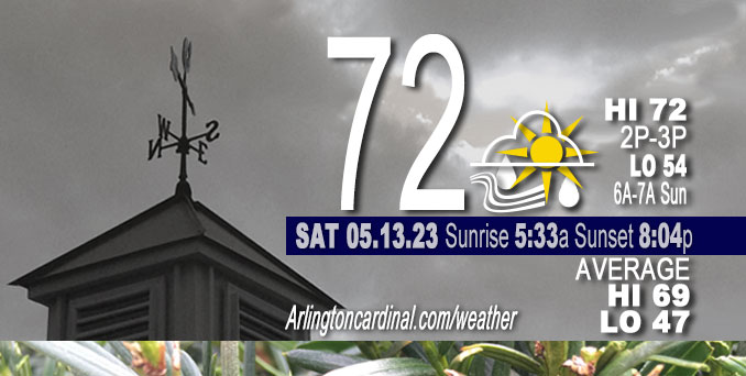
Saturday Hi 72, sprinkles, mostly cloudy to partly sunny, winds NE, 7 to 10 to 8 MPH, G15 to 17 to 14 MPH, 2p to 10p
NWS CHGO | NWS HRLY | /NWSchicago | 🌡
ARLINGTON HEIGHTS WEATHER
▴ forecast7 (Arl. Hts.) | RADAR | WIDE RADAR
⏪ Hrly Data Table | Hrly Future Graph ⏩
IMPORTANT NOTE ON NWS DATA
⏪ Hrly Data Table | Hrly Future Graph ⏩
Hello mobile users! If you encounter a mobile “unfriendly” weather page, turn your phone sideways for a better view.
======================
Saturday and Saturday Evening …
Weather Hazards expected …
Limited Thunderstorm Risk south.
DISCUSSION…
Like last Sunday, renewed thunderstorm development appears poised to take place Saturday along intersection of the northeastward-spreading outflow from central Illinois and southwestward-spreading lake breeze but this time across Livingston, Ford, Iroquois, and Benton counties. So, chances for storms have been confined to areas generally south of a line from La Salle to Rensselaer between 5 and 10 PM CDT.
======================
O’HARE FORECAST …
Forecast Beginning Saturday, May 13, 2023
Saturday: A 20 percent chance of showers before 10am. Mostly cloudy, with a high near 70. East northeast wind 5 to 10 mph, with gusts as high as 20 mph.
Saturday Night: Mostly cloudy, with a low around 57. Northeast wind 10 to 15 mph, with gusts as high as 20 mph.
Sunday: Rain likely, mainly after 2pm. Cloudy, with a high near 58. Northeast wind around 15 mph, with gusts as high as 25 mph. Chance of precipitation is 60%. New precipitation amounts of less than a tenth of an inch possible.
Sunday Night: A 40 percent chance of rain, mainly before 9pm. Cloudy, then gradually becoming partly cloudy, with a low around 45. Northeast wind 5 to 15 mph, with gusts as high as 25 mph.
Monday: Mostly sunny, with a high near 68. Northeast wind around 5 mph.
Monday Night: Partly cloudy, with a low around 53. West wind around 5 mph, with gusts as high as 10 mph.
Tuesday: Mostly sunny, with a high near 77.
Tuesday Night: Partly cloudy, with a low around 50.
Wednesday: Sunny, with a high near 68.
Wednesday Night: Partly cloudy, with a low around 52.
Thursday: A chance of showers. Mostly sunny, with a high near 73.
Thursday Night: A chance of showers. Partly cloudy, with a low around 54.
Friday: A chance of showers. Partly sunny, with a high near 69.
Friday Night: Partly cloudy, with a low around 49.
Saturday: Mostly sunny, with a high near 71.


CHICAGOWEATHERSTATION.COM

ChicagoWeatherStation.com I O’Hare Normal Temps/Precip I O’Hare Record Temps, Precip, Snow
WunderMap® with Temperature/Wind Data || Google: Arlington Heights Area Temps | US TEMPS
Midwest Cloud Cover with Arlington Heights Weather Forecast
ChicagoWeatherStation.com I O’Hare Normal Temps/Precip I O’Hare Record Temps, Precip, Snow
SUNLIGHT DATA FOR SECURITY, TRAFFIC SAFETY, AND SPORTS
SunCalc.net data with solar azimuth and trajectory, times for dawn, sunrise, solar noon, sunset, dusk …
NIGHT SKY THIS MONTH …
Backyard stargazers get a monthly guide to the northern hemisphere’s skywatching events with “Tonight’s Sky.” Check the night sky objects for this month and past months in the playlist from the Space Telescope Science Institute YouTube channel (Musical track The Far River written by Jonn Serrie, from the album And the Stars Go With You courtesy of New World Music Ltd).
Get updates from The Cardinal ALL NEWS FEEDS on Facebook. Just ‘LIKE’ the ‘Arlington Cardinal Page (become a fan of our page). The updates cover all posts and sub-category posts from The Cardinal — Arlingtoncardinal.com. You can also limit feeds to specific categories. See all of The Cardinal Facebook fan pages at Arlingtoncardinal.com/about/facebook …
Help fund The Cardinal Arlingtoncardinal.com/sponsor
/////////////>
Area Forecast Discussion
National Weather Service Chicago/Romeoville, IL
619 AM CDT Sat May 13 2023
.SHORT TERM… Issued at 327 AM CDT Sat May 13 2023
Through Sunday…
Early this morning, we`re seeing widespread fog across areas roughly along and south of I-80. The densest of the fog is concentrated across the far south suburbs and over into northwest Indiana. Over the city, the naturally warmer conditions near the surface are keeping the fog off the ground but a thick cloud deck sits just a few hundred feet up. This fog is expected to hang on well past daybreak meaning driving conditions will be less than favorable this morning across much of the area. Meanwhile, a few light, isolated showers are falling on parts of the metro as well. Despite ample low level moisture in place, rain coverage today should remain mostly isolated given an overall lack of forcing.
The primary forcing mechanism we have to work with today is a weak, disorganized warm front extending from a weakening low centered out in the Plains. Right now, the warm front is draped across central IL barely scraping the southern periphery of the CWA and it`s not expected to deviate much from that position through the day. If anything, some models have the front dipping even further south a bit later this morning before lifting back north near to where it is now. High res guidance is agreeing well on a small cluster of thunderstorms firing up along the front late this afternoon where as much as 2,000 J/kg of MUCAPE will have built up by then. Based on where we expect the front to be at this point, this cluster of storms looks to miss us just to the south, or possibly inching into the far southern CWA. Sufficient instability is expected to extend a good deal north of the warm front, but models are insisting that we won`t be able to realize any of that instability except in isolated instances and keep the area dry for the most part today. We may even sneak in a few rays of sunshine this afternoon as conditions dry out a bit aloft.
Late tonight, the warm front will sharpen up a bit as the parent low inches into the Midwest. The front will be lined up beneath an approaching 700mb jet max. A swath of showers and embedded thunderstorms is expected to develop underneath the nose of the jet and move across the area overnight into early Sunday morning. In the afternoon, a zonally-oriented trough axis will drop through the upper Midwest with an associated vort stream and low level jet working to keep the rain chances going through most of the day. A few elevated thunderstorms are possible during the afternoon on Sunday, although chances are a bit better in the morning. Rain chances will then exit to the south through the evening.
As far as temperatures go, highs today will range from the lower 70s near the IL/WI state line to low 80s south of I-80 nearer to the front. Onshore flow will keep lakeside locales in the 60s today. Much cooler air feeding in behind the front will cap temperatures in the low and mid 60s for most on Sunday. Continued onshore flow means 50s for those along the lake.
Doom/NWS Chicago
