
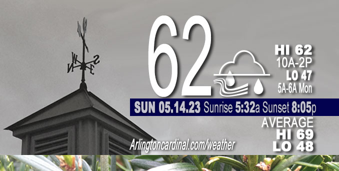
Sunday Hi 62, sprinkles, showers 9a to 8p, mostly cloudy, winds ENE to NE, 10 to 15 to 10 MPH, G17 to 25 to 17 MPH, into Monday 2a
NWS CHGO | NWS HRLY | /NWSchicago | 🌡
ARLINGTON HEIGHTS WEATHER
▴ forecast7 (Arl. Hts.) | RADAR | WIDE RADAR
⏪ Hrly Data Table | Hrly Future Graph ⏩
IMPORTANT NOTE ON NWS DATA
⏪ Hrly Data Table | Hrly Future Graph ⏩
Hello mobile users! If you encounter a mobile “unfriendly” weather page, turn your phone sideways for a better view.
======================
Sunday and Sunday Evening …
Weather Hazards expected …
Limited Thunderstorm Risk southwest of a line from LaSalle to Paxton.
DISCUSSION…
A thunderstorm or two are possible southwest of a line from La Salle to Paxton this evening. No severe weather is expected at this time.
======================
O’HARE FORECAST …
Forecast Beginning Sunday, May 14, 2023
Sunday: Rain likely, mainly after 2pm. Cloudy, with a high near 58. Northeast wind around 15 mph, with gusts as high as 25 mph. Chance of precipitation is 60%. New precipitation amounts of less than a tenth of an inch possible.
Sunday Night: Scattered showers, mainly before 10pm. Mostly cloudy, with a low around 47. Northeast wind 5 to 15 mph, with gusts as high as 25 mph. Chance of precipitation is 40%.
Monday: Partly sunny, with a high near 72. East northeast wind 5 to 10 mph, with gusts as high as 15 mph.
Monday Night: Mostly cloudy, with a low around 51. Calm wind becoming west around 5 mph after midnight.
Tuesday: Sunny, with a high near 78. West wind 5 to 15 mph becoming north in the afternoon.
Tuesday Night: Mostly clear, with a low around 47.
Wednesday: Sunny, with a high near 65.
Wednesday Night: Mostly clear, with a low around 49.
Thursday: A chance of showers after 1pm. Mostly sunny, with a high near 76.
Thursday Night: A chance of showers. Mostly cloudy, with a low around 54.
Friday: A chance of showers. Partly sunny, with a high near 71.
Friday Night: Partly cloudy, with a low around 49.
Saturday: Sunny, with a high near 71.


CHICAGOWEATHERSTATION.COM

ChicagoWeatherStation.com I O’Hare Normal Temps/Precip I O’Hare Record Temps, Precip, Snow
WunderMap® with Temperature/Wind Data || Google: Arlington Heights Area Temps | US TEMPS
Midwest Cloud Cover with Arlington Heights Weather Forecast
ChicagoWeatherStation.com I O’Hare Normal Temps/Precip I O’Hare Record Temps, Precip, Snow
SUNLIGHT DATA FOR SECURITY, TRAFFIC SAFETY, AND SPORTS
SunCalc.net data with solar azimuth and trajectory, times for dawn, sunrise, solar noon, sunset, dusk …
NIGHT SKY THIS MONTH …
Backyard stargazers get a monthly guide to the northern hemisphere’s skywatching events with “Tonight’s Sky.” Check the night sky objects for this month and past months in the playlist from the Space Telescope Science Institute YouTube channel (Musical track The Far River written by Jonn Serrie, from the album And the Stars Go With You courtesy of New World Music Ltd).
Get updates from The Cardinal ALL NEWS FEEDS on Facebook. Just ‘LIKE’ the ‘Arlington Cardinal Page (become a fan of our page). The updates cover all posts and sub-category posts from The Cardinal — Arlingtoncardinal.com. You can also limit feeds to specific categories. See all of The Cardinal Facebook fan pages at Arlingtoncardinal.com/about/facebook …
Help fund The Cardinal Arlingtoncardinal.com/sponsor
/////////////>
Area Forecast Discussion
National Weather Service Chicago/Romeoville, IL
632 AM CDT Sun May 14 2023
.SHORT TERM… Issued at 249 AM CDT Sun May 14 2023
Through Monday…
Mother`s Day forecast isn`t clear cut with a lot of moving pieces coming into play to produce some rain over a sizable portion of our CWA, favoring our western counties.
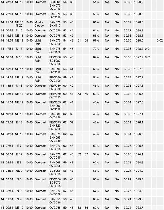
Early this morning, an axis of rain with some occasional lightning extends NW-SE across about the southwestern 1/3 of our CWA. This activity seems to be tied to a shear axis that is aligned fairly closely with where the warm front intersects 925mb given the tight theta-e gradient evident in objective analysis. This axis of rain has been moving slowly northeast, but encountering a noticeably drier air mass with evidence of this axis of rain dissipating. Plan to carry pops associated with this axis through at least early to mid morning, though if it keeps shifting northeast into drier air mass it could dry up completely before that.
Elsewhere, the upper low responsible for the severe weather over the Plains and Cornbelt the past couple/few days has devolved into an open wave and remnant vort max evident on water vapor imagery over southwest MN/southeast SD Sat evening before it became obscured by higher level moisture streaming north on western flank of upper high. Guidance suggests this remnant vort will undergo stretching deformation today, weakening further with part of this vorticity heading west and perhaps a slightly more coherent slug of higher positive vorticity being pulled east by the slightly stronger westerly flow.
Regional WSR-88D mosaic is depicting a large area of rain with a couple embedded thunderstorms over southern MN associated with this feature. Quick weather geek moment, looping regional radar you can actually see the deformation taking place with divergent motion of precip elements over southern MN (some rain is moving east to west while other rain moves west to east). The east- southeastward shearing portion of this wave seems poised to drag some of the rain over southern MN east and southeast toward northern IL today. Low levels over about the northeast half of the CWA are pretty dry, suggesting that this rain may struggle to reach the ground initially. While western CWA, considerably more saturated/moist low levels suggests rain should reach the ground more readily and earlier. Due to the drier air, it is less clear that rain will reach the ground today, so will be carrying a southwest to northeast pop gradient. Best chance of rain (if it rains) into most of the Chicago area looks to be later this afternoon. Farther west, rain could begin this morning and continue on and off through the day.
The low level northeasterly flow will not only be advecting in a drier air mass, but also weak cold air advection. Cloud cover and CAA should keep temps fairly chilly by mid May standards near the lake and over Chicago metro. Farther southwest, temps will have more opportunity to warm up a bit, particularly if there are sizable breaks in the rain and a peak or two of sunshine.
By tonight, the remnants of the upper low look to completely dissipate. However, a northern stream shortwave trough is progged to drop due south across the area. Forcing with this wave could be enough to keep some showers going tonight, particularly southern CWA where moisture profiles look more conducive.
Monday looks dry with seasonable temperatures. There will likely be some high cloudiness lingering, but enough filtered sunshine should allow highs to climb into the low to mid 70s across the area. Winds off the lake will keep lake adjacent areas much cooler, likely struggling to reach 60F.
-Izzi/NWS Chicago
