
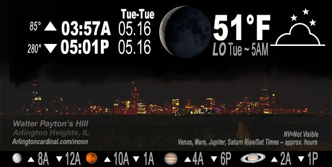
🌘 🌑 🌗 🌕 Waning Crescent Moon, sky cover overnight Mon. to Tue. 90% to 60%, winds SW to W, 3 to 8 to 5 MPH, Low 51, 5a to 6a
NWS CHGO | NWS HRLY | /NWSchicago | 🌡
ARLINGTON HEIGHTS WEATHER
▴ forecast7 (Arl. Hts.) | RADAR | WIDE RADAR
IMPORTANT NOTE ON NWS DATA
Hello mobile users! If you encounter a mobile “unfriendly” weather page, turn your phone sideways for a better view.
======================
NIGHT FORECASTS …
NOTE: Keep in mind lunar rise and set times don’t always correspond with night weather and early morning lows because on some days during the month the moon is visible in the sky predominantly during the daytime hours.
Overnight Monday to Tuesday …
No Weather Hazards expected …
Low 51°F to 52°F was actually just after midnight.
DISCUSSION…
No significant changes to going forecast this Monday evening, other than to lower pops across far southern cwa late tonight/early Tuesday to just slight chance.
======================
O’HARE FORECAST …
Forecast Beginning Monday Night, May 15, 2023 …
Monday Night: Mostly cloudy, with a low around 52. Calm wind becoming west around 5 mph after midnight.
Tuesday: Mostly sunny, with a high near 78. West wind 5 to 15 mph, with gusts as high as 20 mph.
Tuesday Night: Mostly clear, with a low around 46. North northeast wind 10 to 15 mph, with gusts as high as 30 mph.
Wednesday: Sunny, with a high near 62.
Wednesday Night: Mostly clear, with a low around 47.
Thursday: Sunny, with a high near 74.
Thursday Night: A chance of showers. Partly cloudy, with a low around 54.
Friday: A chance of showers. Partly sunny, with a high near 68.
Friday Night: Partly cloudy, with a low around 49.
Saturday: Sunny, with a high near 69.
Saturday Night: Mostly clear, with a low around 51.
Sunday: Sunny, with a high near 75.
O’Hare forecast archive and hourly weather observations archive are available HERE on the CARDINAL NEWS Magazine.
Arlingtoncardinal.com/moonphases
Arlingtoncardinal.com/nightsky
NIGHT SKY THIS MONTH …
Check the night sky objects for this month and past months in the playlist from the Space Telescope Science Institute YouTube channel Backyard stargazers get a monthly guide to the northern hemisphere’s skywatching events with “Tonight’s Sky” (Musical track The Far River written by Jonn Serrie, from the album And the Stars Go With You courtesy of New World Music Ltd. Musical track The Far River written by Jonn Serrie, from the album And the Stars Go With You courtesy of New World Music Ltd).
Telephoto lens, ISO 100, f/11, Shutter Speed 1/100 to 1/125 for the Moon.
Get updates from The Cardinal ALL NEWS FEEDS on Facebook. Just ‘LIKE’ the ‘Arlington Cardinal Page (become a fan of our page). The updates cover all posts and sub-category posts from The Cardinal — Arlingtoncardinal.com. You can also limit feeds to specific categories. See all of The Cardinal Facebook fan pages at Arlingtoncardinal.com/about/facebook …
Help fund The Cardinal Arlingtoncardinal.com/sponsor
Telephoto lens, ISO 1600, f/11, Shutter Speed 2.5″ for the skyline. The skyline exposure was toned down, and brightness and contrast was adjusted in Photoshop.
/////////////>
Area Forecast Discussion
National Weather Service Chicago/Romeoville, IL
848 PM CDT Mon May 15 2023
.UPDATE… Issued at 848 PM CDT Mon May 15 2023
No significant changes to going forecast this evening, other than to lower pops across far southern cwa late tonight/early Tuesday to just slight chance. Otherwise, forecast is in good shape.
Evening surface analysis places west-east high pressure ridge from Nebraska eastward across the IL/WI border into southern lower Michigan. Northeasterly low level winds have brought much drier air into the forecast area since yesterday`s cold frontal passage, with dew points ranging from the teens/low 20s along the North Shore north of Chicago, to the mid-upper 40s across the western/southwest parts of the cwa. More humid conditions have pushed well downstate. A low-amplitude mid-level short wave is progged to track across central IL later tonight into early Tuesday, though the WFO LOT cwa looks to be on the far northern fringe of any precip associated with this disturbance. High-res guidance trends keep measurable QPF south of the forecast area across central IL/IN, and in collaboration with our southern neighbors have decreased pops to only slight chance along our southern border early Tuesday morning.
Otherwise, going forecast appears to have things well-handled into Tuesday, with mainly mid and high level cloud cover and a brief warm up tomorrow ahead of an approaching well-advertised “pneumonia front” later in the day.
Ratzer
&&
.SHORT TERM… Issued at 305 PM CDT Mon May 15 2023
Through Tuesday night…
Key Forecast Message and Concern:
* Timing of lake enhanced “pneumonia” front passage Tuesday PM and associated sharp temperature drop and quick uptick in winds
Weak surface high pressure ridging will bring light winds overnight tonight, and if high clouds aren`t too thick, will enable lows in the mid-upper 40s in favored cool spots near and north of I-80. A short-wave passing to our south will fight a dry antecedent air mass and decreasing forcing with northward extent to possibly bring spotty light rain/showers to areas near and south of US-24 overnight into Tuesday morning.
Partly cloudy if not mostly sunny skies, especially north, dee Pmixing, breezy northwest winds, and dew points mixing out will support highs reaching the mid 70s to around 80F/low 80s Tuesday afternoon, warmest I-80 and north. Sharp land-lake thermal gradient will probably enable a weak lake breeze to slip inland and bring modest cooling near the immediate IL and IN shore prior to the much sharper temperature drop pegged for the late afternoon-early evening.
Regarding the “pneumonia” front, no big changes in thinking, though the exact timing is medium confidence. The HRW CAMs and NAMnest feature an earlier frontal approach and passage timing than the HRRR and RAP by a couple hours. Conceptually these fronts verify in line with faster timing, so hedged that way (maybe officially a hair slower than previous fcst), and we`ll be able to refine the exact timing with radar and observational trends on Tuesday. Northwest winds will quickly shift to north-northeast and gust up to 25-30 mph, and possibly briefly stronger up to 35 mph near the immediate shore. Breezy north-northeast winds should continue into the evening behind the inland surging front, though will decrease in magnitude with time.
Temperatures will drop from the 70s to 50s within 1-2 hours of frontal passage with several miles of the lake, quickest closer to the shore, with a slower but steady fall farther inland. Expect lows in the 40s to around 50 Tuesday night, coolest and possibly right down around 40F far north. Finally, the short-wave and front may team up for a few light showers or sprinkles behind the front Tuesday evening, favored over inland northern Illinois, where the front aloft will be undercut later than near the lake by the surging lake enhanced front. Most locations will remain dry, and kept PoPs in slight chance range. No thunderstorms are expected.
Castro/NWS Chicago
