
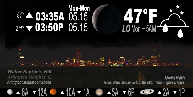
🌘 🌑 🌗 🌕 Waning Crescent Moon, sky cover overnight Sun. to Mon. 80% to 40%, winds NE to N to NE, 13 to 8 MPH, G20 MPH, 9p to 10p, Low 51, 5a to 7a
NWS CHGO | NWS HRLY | /NWSchicago | 🌡
ARLINGTON HEIGHTS WEATHER
▴ forecast7 (Arl. Hts.) | RADAR | WIDE RADAR
IMPORTANT NOTE ON NWS DATA
Hello mobile users! If you encounter a mobile “unfriendly” weather page, turn your phone sideways for a better view.
======================
NIGHT FORECASTS …
NOTE: Keep in mind lunar rise and set times don’t always correspond with night weather and early morning lows because on some days during the month the moon is visible in the sky predominantly during the daytime hours.
Overnight Sunday to Monday …
Weather Hazards expected …
Limited Thunderstorm Risk (ended).
DISCUSSION…
Convective instability shifted south of the forecast area into central IL, and thus removed any lingering mention of thunder along our LOT/ILX border.
Note: Actual low temperature was 51°F, that was above the forecast low of 47°F.
======================
O’HARE FORECAST …
Forecast Beginning Sunday Night, May 14, 2023 …
Sunday night: Scattered showers, mainly before 10pm. Mostly cloudy, with a low around 47. Northeast wind 5 to 15 mph, with gusts as high as 25 mph. Chance of precipitation is 40%.
Monday: Partly sunny, with a high near 69. East northeast wind 5 to 10 mph.
Monday Night: Mostly cloudy, with a low around 52. Calm wind becoming west around 5 mph after midnight.
Tuesday: Mostly sunny, with a high near 78. West wind 5 to 15 mph, with gusts as high as 20 mph.
Tuesday Night: Mostly clear, with a low around 46. North northeast wind 10 to 15 mph, with gusts as high as 30 mph.
Wednesday: Sunny, with a high near 62.
Wednesday Night: Mostly clear, with a low around 47.
Thursday: Sunny, with a high near 74.
Thursday Night: A chance of showers. Partly cloudy, with a low around 54.
Friday: A chance of showers. Partly sunny, with a high near 68.
Friday Night: Partly cloudy, with a low around 49.
Saturday: Sunny, with a high near 69.
Saturday Night: Mostly clear, with a low around 51.
Sunday: Sunny, with a high near 75.
O’Hare forecast archive and hourly weather observations archive are available HERE on the CARDINAL NEWS Magazine.
Arlingtoncardinal.com/moonphases
Arlingtoncardinal.com/nightsky
NIGHT SKY THIS MONTH …
Check the night sky objects for this month and past months in the playlist from the Space Telescope Science Institute YouTube channel Backyard stargazers get a monthly guide to the northern hemisphere’s skywatching events with “Tonight’s Sky” (Musical track The Far River written by Jonn Serrie, from the album And the Stars Go With You courtesy of New World Music Ltd. Musical track The Far River written by Jonn Serrie, from the album And the Stars Go With You courtesy of New World Music Ltd).
Telephoto lens, ISO 100, f/11, Shutter Speed 1/100 to 1/125 for the Moon.
Get updates from The Cardinal ALL NEWS FEEDS on Facebook. Just ‘LIKE’ the ‘Arlington Cardinal Page (become a fan of our page). The updates cover all posts and sub-category posts from The Cardinal — Arlingtoncardinal.com. You can also limit feeds to specific categories. See all of The Cardinal Facebook fan pages at Arlingtoncardinal.com/about/facebook …
Help fund The Cardinal Arlingtoncardinal.com/sponsor
Telephoto lens, ISO 1600, f/11, Shutter Speed 2.5″ for the skyline. The skyline exposure was toned down, and brightness and contrast was adjusted in Photoshop.
/////////////>
Area Forecast Discussion
National Weather Service Chicago/Romeoville, IL
848 PM CDT Sun May 14 2023
.UPDATE… Issued at 848 PM CDT Sun May 14 2023
Only minor adjustments made to going forecast this evening, mainly to add hourly detail to pop grids as showers decrease in coverage, as well as to remove thunder mention from our far southern counties.
Weakening surface low pressure was analyzed near Kansas City this evening, with a sharp quasi-stationary front extending southeast through southern IL and western KY. Farther north, an elongated area of seasonably strong high pressure stretched from the northern Plains through the northern Great Lakes region. Within the gradient region across northern IL/northwest IN, somewhat blustery northeast winds continued to bring cooler air into the area with temperatures currently in the low-mid 50s across much of the forecast area. Light rain/showers have persisted area since this afternoon, driven largely by frontogenetic forcing (most notably in the 700-500 mb layer) within the elevated baroclinic zone north of the stationary front along with some aid from upper level divergence in the right rear entrance region to an upper level jet streak to our east. High- res model guidance depicts both of these forcing mechanisms weakening tonight as the upper jet streak peels off to the east- southeast, and the elevated baroclinic zone weakens as the surface front sags south. The result will be a continued decrease in shower coverage through late evening, especially across the northern half of the forecast area. Farther south, some lingering f-gen forcing in the 925-850 mb layer may allow for some isolated showers to persist at times into the overnight hours mainly south of the I-80 corridor.
With these trends already evident in regional radar imagery, have made some tweaks to pops across the area to depict gradually decreasing coverage of showers across the north, and maintained low pops (20 percent) overnight in the south. RAP mesoanalysis and forecast soundings indicate all convective instability has shifted south of the forecast area into central IL, and thus removed any lingering mention of thunder along our LOT/ILX border.
Updated digital/text forecast products available.
Ratzer
&&
.SHORT TERM… Issued at 235 PM CDT Sun May 14 2023
Through Monday…
A broad region of showers is ongoing early this afternoon in areas generally northwest of I-55. This will continue to slowly drift southeast the rest of the afternoon. So far it has struggled to make inroads over the city thanks to much drier low levels indicated by O`Hare and Midway dewpoints near 40F. At times, cloud tops have grown tall enough to see an few lightning strikes embedded in the showers, though so far this has been limited to locales along and west of I-39. Think the potential for lightning the rest of the afternoon into early evening will be limited to areas in Illinois along and south of a Mendota to Kankakee line.
Hi-res guidance begins to thin out the area of showers into a narrower band with isolated showers that persists through the overnight hours. Exactly where this band ends up remains somewhat in question so it felt prudent to carry a mention for isolated showers for most areas overnight. Think in general these showers will be on a diminishing trend toward daybreak, though cannot rule out a few light showers/sprinkles through the day mainly south of I-80.
Depending on how long these light showers continue and greater cloud coverage it could slow our warming on Monday. Left the temperature forecast mostly unchanged with upper 60s to lower 70s. Northeast winds and an afternoon lake breeze will kee Ptemperatures near the shore in the upper 50s to lower 60s.
Taking a broader look at the region, showers are ongoing across Oklahoma and Kansas on the western side of the upper ridge. Model guidance suggests this activity will continue to lift and ultimately round the ridge into central Illinois. The northern edge of these showers may sneak into areas south of I-80 late Monday night. More details about shower chances Monday night into Tuesday are provided in the Long Term Discussion below.
Petr/NWS Chicago
