
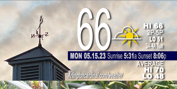
Monday Hi 68, partly sunny, mostly sunny north, winds N to NE to E to NE to SE, 5 to 10 to 3 MPH
NWS CHGO | NWS HRLY | /NWSchicago | 🌡
ARLINGTON HEIGHTS WEATHER
▴ forecast7 (Arl. Hts.) | RADAR | WIDE RADAR
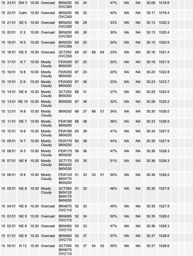
⏪ Hrly Data Table | Hrly Future Graph ⏩
IMPORTANT NOTE ON NWS DATA
⏪ Hrly Data Table | Hrly Future Graph ⏩
Hello mobile users! If you encounter a mobile “unfriendly” weather page, turn your phone sideways for a better view.
======================
Monday and Monday Evening …
Pending
DISCUSSION…
Pending
======================
O’HARE FORECAST …
Forecast Beginning Monday, May 15, 2023
Monday: Partly sunny, with a high near 69. East northeast wind 5 to 10 mph.
Monday Night: Mostly cloudy, with a low around 52. Calm wind becoming west around 5 mph after midnight.
Tuesday: Partly sunny, with a high near 81. West northwest wind 5 to 15 mph, with gusts as high as 20 mph.
Tuesday Night: Partly cloudy, with a low around 48. North northeast wind 10 to 15 mph, with gusts as high as 25 mph.
Wednesday: Sunny, with a high near 62. Northeast wind around 10 mph, with gusts as high as 15 mph.
Wednesday Night: Mostly clear, with a low around 47. Northeast wind 5 to 10 mph becoming southeast after midnight.
Thursday: Sunny, with a high near 75. South southeast wind around 10 mph.
Thursday Night: A 20 percent chance of showers after 1am. Partly cloudy, with a low around 56.
Friday: A 50 percent chance of showers. Mostly sunny, with a high near 73.
Friday Night: A chance of showers. Partly cloudy, with a low around 52.
Saturday: Sunny, with a high near 69.
Saturday Night: Mostly clear, with a low around 53.
Sunday: Sunny, with a high near 73.
Sunday Night: Mostly clear, with a low around 51.
Monday: Sunny, with a high near 73.


CHICAGOWEATHERSTATION.COM

ChicagoWeatherStation.com I O’Hare Normal Temps/Precip I O’Hare Record Temps, Precip, Snow
WunderMap® with Temperature/Wind Data || Google: Arlington Heights Area Temps | US TEMPS
Midwest Cloud Cover with Arlington Heights Weather Forecast
ChicagoWeatherStation.com I O’Hare Normal Temps/Precip I O’Hare Record Temps, Precip, Snow
SUNLIGHT DATA FOR SECURITY, TRAFFIC SAFETY, AND SPORTS
SunCalc.net data with solar azimuth and trajectory, times for dawn, sunrise, solar noon, sunset, dusk …
NIGHT SKY THIS MONTH …
Backyard stargazers get a monthly guide to the northern hemisphere’s skywatching events with “Tonight’s Sky.” Check the night sky objects for this month and past months in the playlist from the Space Telescope Science Institute YouTube channel (Musical track The Far River written by Jonn Serrie, from the album And the Stars Go With You courtesy of New World Music Ltd).
Get updates from The Cardinal ALL NEWS FEEDS on Facebook. Just ‘LIKE’ the ‘Arlington Cardinal Page (become a fan of our page). The updates cover all posts and sub-category posts from The Cardinal — Arlingtoncardinal.com. You can also limit feeds to specific categories. See all of The Cardinal Facebook fan pages at Arlingtoncardinal.com/about/facebook …
Help fund The Cardinal Arlingtoncardinal.com/sponsor
/////////////>
Area Forecast Discussion
National Weather Service Chicago/Romeoville, IL
617 AM CDT Mon May 15 2023
.SHORT TERM… Issued at 249 AM CDT Mon May 15 2023
Through Tuesday night…
Surface front has now settled well south of the area with northeasterly winds ushering drier air in the low levels. Aloft, upper ridge over the lower and middle Mississippi valley has been shoved south some by the shortwave trough responsible for Sunday evening`s showers. Extensive cirrus shield rotating around this upper ridge should blanket the area today, resulting in a filtered sunshine. Despite the cirrus, temps should mostly top out around 70, though the steady flow off the lake should keep temps at the shore struggling to even tag 60 today.
Pretty good model consensus in analyzing a shortwave trough over eastern Oklahoma early this morning. Hard to see much evidence of this feature in satellite or observational data, but given the strong model agreement probably safe to assume a wave is tucked in there under the cirrus deck. This wave is progged to work its way around the periphery of the upper high and trigger convection over the Ozarks this afternoon. This wave is then progged to continue east across central/southern IL tonight, with some guidance suggesting the northern extent of its precip shield reaching into our southern CWA. Given the antecedent dry air, confidence isn`t high in precip extending as far north as our CWA, so just introduced some low end chance to slight chance pops for showers late tonight into Tuesday morning.
As this wave pulls east Tuesday morning, look for decreasing cloudiness Tuesday afternoon, with northern CWA likely to see a good deal of sunshine during the afternoon. The sunshine, westerly winds, and 925mb temps in the mid-upper teens support highs in the upper 70s to lower 80s. Biggest story Tuesday will be backdoor cold front progged to accelerate down the lake, possibly bringing a dramatic end to warm temps with near instantaneous temp drop of 10-20F along the lakefront late Tuesday afternoon and evening. Will likely see some gusty north-northeast winds immediately behind front, further adding to the chill of the crashing temperatures.
Some of the CAMs are showing some convection breaking out with the front, mainly western CWA with best chance of a shower or storm out toward Rockford late Tue PM/early Tues evening. Farther east, closer to the lake, the frontal forcing will be more shallow as marine influences cause the near sfc portion of the front to accelerate more quickly than aloft, also causing near sfc portion of the front to out run stronger synoptic forcing with the upper trough. Moisture, even over western CWA, looks pretty paltry, so unclear if anything will develop and if it does, it`s likely be pretty isolated. For now just introduced some small pops NW CWA late in the afternoon into the early evening around Rockford and vicinity.
Front should continue to sweep across the remainder of our CWA Tuesday evening with the associated temp drop becoming less dramatic as it gets farther from the lake and as pre-frontal temps begin to cool diurnally after sunset.
– Izzi/NWS Chicago
