
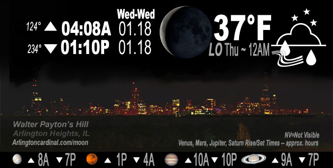
🌘 🌑 🌗 🌕 Waning Crescent Moon, rain, sky cover overnight Wed. to Thu. 100%, winds ENE to SE to SW, 10 to 22 to 7 MPH, G16 to 34 to 11 MPH, Low 37, 12a to 1a
NWS CHGO | NWS HRLY | /NWSchicago | 🌡
ARLINGTON HEIGHTS WEATHER
▴ forecast7 (Arl. Hts.) | RADAR | WIDE RADAR
IMPORTANT NOTE ON NWS DATA
======================
NIGHT FORECASTS …
NOTE 1: Forecast and information text below may refer to a previous night on Arlingtoncardinal.com, and might not be updated until late afternoon, evening, or overnight. However, Night Sky archives on CARDINAL NEWS Magazine include text forecasts that correspond to the lunar phase graphic above.
NOTE 2: Keep in mind lunar rise and set times don’t always correspond with night weather and early morning lows because on some days during the month the moon is visible in the sky predominantly during the daytime hours.
Overnight Wednesday/Thursday …
Weather Hazards expected …
Limited Non-Thunderstorm Wind Risk.
Significant Fog Risk.
Limited Snow and Sleet Risk far north and northwest Illinois.
DISCUSSION…
A wintry mix of snow, sleet, and rain may occur for up to a few hours tonight roughly along and north of Interstate 88. Slushy snow accumulations up to 1 to 2 inches and minor travel disruptions are possible, particularly north and west of Rockford.
Winds will also be breezy this evening with 30+ mph gusts expected at times. Higher gusts closer to 40 mph cannot be ruled out.
Areas of fog are likely to develop late tonight into Thursday morning. Some locally dense fog is possible.
Hello mobile users! If you encounter mobile “unfriendly” weather page, turn your phone sideways for a better view.
======================
O’HARE FORECAST …
Forecast Beginning Wednesday Night, Jan. 18, 2023 …
Wednesday Night: A chance of rain before 8pm, then rain, possibly mixed with sleet between 8pm and 9pm, then rain after 9pm. Areas of fog after midnight. Low around 36. Breezy, with an east wind 15 to 20 mph becoming south southeast 5 to 10 mph after midnight. Winds could gust as high as 35 mph. Chance of precipitation is 100%. Little or no sleet accumulation expected.
Thursday: Rain likely, mainly between 9am and 3pm. Areas of fog before 10am. Otherwise, cloudy, with a high near 44. South wind 5 to 15 mph becoming west in the afternoon. Winds could gust as high as 25 mph. Chance of precipitation is 60%. New precipitation amounts of less than a tenth of an inch possible.
Thursday Night: A slight chance of rain before 9pm, then a slight chance of rain and snow showers between 9pm and midnight, then a chance of flurries after midnight. Cloudy, with a low around 30. Breezy, with a west wind 15 to 20 mph, with gusts as high as 30 mph. Chance of precipitation is 20%.
Friday: Cloudy, with a high near 33. West northwest wind around 15 mph, with gusts as high as 25 mph.
Friday Night: Mostly cloudy, with a low around 25.
Saturday: Partly sunny, with a high near 33.
Saturday Night: A chance of snow after midnight. Cloudy, with a low around 29.
Sunday: A chance of snow. Mostly cloudy, with a high near 34.
Sunday Night: Mostly cloudy, with a low around 27.
Monday: Mostly cloudy, with a high near 35.
Monday Night: Mostly cloudy, with a low around 29.
Tuesday: Partly sunny, with a high near 36.
O’Hare forecast archive and hourly weather observations archive are available HERE on the CARDINAL NEWS Magazine.
Arlingtoncardinal.com/moonphases
Arlingtoncardinal.com/nightsky
NIGHT SKY THIS MONTH …
Check the night sky objects for this month and past months in the playlist from the Space Telescope Science Institute YouTube channel Backyard stargazers get a monthly guide to the northern hemisphere’s skywatching events with “Tonight’s Sky” (Musical track The Far River written by Jonn Serrie, from the album And the Stars Go With You courtesy of New World Music Ltd. Musical track The Far River written by Jonn Serrie, from the album And the Stars Go With You courtesy of New World Music Ltd).
Telephoto lens, ISO 100, f/11, Shutter Speed 1/100 to 1/125 for the Moon.
Get updates from The Cardinal ALL NEWS FEEDS on Facebook. Just ‘LIKE’ the ‘Arlington Cardinal Page (become a fan of our page). The updates cover all posts and sub-category posts from The Cardinal — Arlingtoncardinal.com. You can also limit feeds to specific categories. See all of The Cardinal Facebook fan pages at Arlingtoncardinal.com/about/facebook …
Help fund The Cardinal Arlingtoncardinal.com/sponsor
Telephoto lens, ISO 1600, f/11, Shutter Speed 2.5″ for the skyline. The skyline exposure was toned down, and brightness and contrast was adjusted in Photoshop.
Area Forecast Discussion
National Weather Service Chicago/Romeoville, IL
524 PM CST Thu Jan 19 2023
.SHORT TERM… Issued at 250 PM CST Thu Jan 19 2023
Through Friday night…
Main forecast concerns… *Rain showers continue to move through the area this afternoon with some areas seeing a transition to snow showers this evening. Little to no accumulation is expected.
*Blustery winds persisting through tonight before gradually easing Friday afternoon.
Showers are continuing to move across northeastern Illinois this afternoon under the influence of an upper-level low that continues to swirl above the southern Great Lakes. At this time showers are falling in the form of rain, but recent aircraft soundings are showing that the most of the column is below freezing except for the lowest couple thousand feet or so. Forecast soundings continue to show that this surface warm layer should cool as cold advection strengthens this evening which looks to transition the rain showers over to snow showers/flurries, especially for areas north of I-88, after 6 PM. However, there continues to be some uncertainty as to the coverage of snow showers this evening as forecast soundings are showing that drier air would be trying to work into the DGZ which would limit the snow production and keep precipitation more along the lines of flurries or a rain-snow mix. Given this uncertainty I did maintain a mention of rain-snow mix for most of the Chicago metro and areas south of I-80 where temperature profiles look more marginal. Any snow showers/flurries that do materialize this evening will lead to little or no accumulations due to the wet and above freezing ground conditions, although some visibility reductions may be seen under some of the snow showers.
In addition to the showers, winds will also continue to increase this evening as the cold advection allows the atmosphere to mix into stronger winds aloft. Gusts around 25 to 30 mph are expected to persist through the overnight hours and into Friday morning before winds gradually start to ease Friday afternoon. The combination of these breezy conditions and the lowering temperatures will create wind chills in the upper teens and lower 20s by Friday morning.
Heading into our Friday, the showers/flurries will be coming to an end by daybreak for most with the exception of some lingering flurries in far northeastern Porter County, IN. However, skies will remain mostly cloudy through Friday night as mid-level moisture lingers aloft. The overcast skies in combination with the cold advection will keep temperatures more in line with typical January temperatures as highs are expected to top out in the low to mid 30s Friday afternoon. Friday night will also be chilly with temperatures dipping into the low to mid 20s by Saturday morning.
Yack/NWS Chicago
