
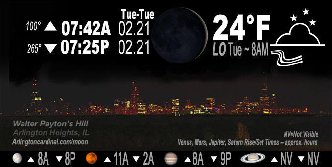
🌒 🌓 🌕 🌗 Waxing Crescent Moon, sky cover overnight Mon. to Tue. 10% to 78% to 14%, winds SE to SW to WNW, 6 to 15 to 20 MPH, G22 to 38 to 14 MPH end 12p, Low 24, 8a to 9a
NWS CHGO | NWS HRLY | /NWSchicago | 🌡
ARLINGTON HEIGHTS WEATHER
▴ forecast7 (Arl. Hts.) | RADAR | WIDE RADAR
IMPORTANT NOTE ON NWS DATA
======================
NIGHT FORECASTS …
NOTE: Keep in mind lunar rise and set times don’t always correspond with night weather and early morning lows because on some days during the month the moon is visible in the sky predominantly during the daytime hours.
Overnight Monday/Tuesday …
No Weather Hazards expected
Gusty winds up to 38 MPH around 6:00 a.m. then diminishing to around 14 MPH and ending around 12:00 p.m.
DISCUSSION…
A cold front moving in across Chicagoland overnight Monday to Tuesday, will result in a period of gusty west-northwesterly winds. Mild weather at midnight will become cold weather that causes moderate frostbite on gloveless fingers Tuesday morning. These gusty winds are expected to abate across the area during the mid to late morning hours Tuesday as the surface gradient eases with the approach of a surface ridge of high pressure. While these winds will become light across the area into the afternoon, a colder airmass shifting into the area early this morning will keep temperatures from warming above the 30s Tuesday.
Hello mobile users! If you encounter mobile “unfriendly” weather page, turn your phone sideways for a better view.
======================
O’HARE FORECAST …
Forecast Beginning Monday Night, Feb. 20, 2023 …
Monday Night: Mostly cloudy, with a low around 24. Breezy, with a west wind 15 to 20 mph, with gusts as high as 30 mph.
Tuesday: Sunny, with a high near 38. Breezy, with a west northwest wind 15 to 20 mph becoming west 5 to 10 mph in the afternoon. Winds could gust as high as 35 mph.
Tuesday Night: Mostly cloudy, with a low around 33. East wind 5 to 15 mph, with gusts as high as 25 mph.
Wednesday: Rain likely, possibly mixed with sleet before noon, then rain. High near 36. Breezy, with an east northeast wind 15 to 20 mph, with gusts as high as 30 mph. Chance of precipitation is 100%. New sleet accumulation of less than a half inch possible.
Wednesday Night: Rain, mainly before midnight. Low around 33. Breezy, with an east northeast wind 15 to 20 mph decreasing to 5 to 10 mph after midnight. Winds could gust as high as 35 mph. Chance of precipitation is 100%.
Thursday: A 20 percent chance of rain before noon. Mostly cloudy, with a high near 46. Windy.
Thursday Night: Mostly cloudy, with a low around 16. Breezy.
Friday: Partly sunny, with a high near 26.
Friday Night: Mostly cloudy, with a low around 23.
Saturday: Partly sunny, with a high near 40.
Saturday Night: Partly cloudy, with a low around 25.
Sunday: Sunny, with a high near 38.
Sunday Night: Mostly clear, with a low around 25.
Monday: A chance of rain. Partly sunny, with a high near 44. Breezy.
O’Hare forecast archive and hourly weather observations archive are available HERE on the CARDINAL NEWS Magazine.
Arlingtoncardinal.com/moonphases
Arlingtoncardinal.com/nightsky
NIGHT SKY THIS MONTH …
Check the night sky objects for this month and past months in the playlist from the Space Telescope Science Institute YouTube channel Backyard stargazers get a monthly guide to the northern hemisphere’s skywatching events with “Tonight’s Sky” (Musical track The Far River written by Jonn Serrie, from the album And the Stars Go With You courtesy of New World Music Ltd. Musical track The Far River written by Jonn Serrie, from the album And the Stars Go With You courtesy of New World Music Ltd).
Telephoto lens, ISO 100, f/11, Shutter Speed 1/100 to 1/125 for the Moon.
Get updates from The Cardinal ALL NEWS FEEDS on Facebook. Just ‘LIKE’ the ‘Arlington Cardinal Page (become a fan of our page). The updates cover all posts and sub-category posts from The Cardinal — Arlingtoncardinal.com. You can also limit feeds to specific categories. See all of The Cardinal Facebook fan pages at Arlingtoncardinal.com/about/facebook …
Help fund The Cardinal Arlingtoncardinal.com/sponsor
Telephoto lens, ISO 1600, f/11, Shutter Speed 2.5″ for the skyline. The skyline exposure was toned down, and brightness and contrast was adjusted in Photoshop.
Area Forecast Discussion
National Weather Service Chicago/Romeoville, IL
322 AM CST Tue Feb 21 2023
.SHORT TERM… Issued at 247 PM CST Mon Feb 20 2023
Through Tuesday night…
There are no significant weather concerns expected here in the short term forecast period. A clipper system centered over northern Minnesota at press time will continue to progress eastward throughout the remainder of this afternoon and tonight, likely reaching the eastern tip of the Upper Peninsula of Michigan by daybreak tomorrow. The system`s cold front will sweep through our forecast area late this evening into the early overnight hours, causing the preceding south-southwesterly winds to veer around to a westerly, and eventually, a northwesterly direction. Cold air advection will accordingly commence, leading to temperatures that will bottom out in the 20s across most of our CWA early Tuesday morning, save for portions of interior northern Illinois, where lows in the upper teens are favored, and our far southeastern CWA, where temperatures may only fall into the low 30s before diurnal warming is initiated after daybreak.
Winds will also become blustery tonight as a stabilized pre-frontal boundary layer makes way for more unstable low-level thermal profiles in the post-frontal cold air advection regime. Mixing heights growing to about 2000-2500 ft AGL in this regime should facilitate the transfer of higher momentum flow down to ground level that will likely correlate to winds gusting to around 35 mph at the surface for a few hour long period overnight into early Tuesday morning. Increasing DPVA aloft should also allow for an uptick in mid-level cloud cover to be seen tonight, and while some sprinkles or a stray light shower or two can`t be ruled out, the odds of measurable precipitation occurring appear to be too low to warrant carrying mentionable PoPs in the forecast for tonight.
Clouds are expected to scatter out tomorrow morning as the clipper system and the associated mid/upper-level trough continue to move out of the region. The blustery morning winds will subside substantially by the afternoon as high pressure builds into the area, and this eventual cessation of cold air advection along with mostly clear skies should allow high temperatures to reach the mid 30s to mid 40s in our CWA with the colder temperatures occurring in our northern counties and the milder temperatures occurring in our southern counties.
Temperatures will likely fall off by a of couple degrees after sunset on Tuesday, but will eventually flatline and even begin to rise overnight in response to warm air advection in advance of our next system. The increasing low-level warm air advection and isentropic ascent may push some convective rain shower activity into primarily our southern CWA overnight, while earlier Tuesday evening, light snow associated with a separate region of synoptic ascent to our north may graze our northern tier of counties, but the bulk of our mid-week precipitation won`t arrive until after daybreak Wednesday. For more details on the mid-week system and the precipitation that it will bring, reference the long term discussion below.
Ogorek/NWS Chicago
