
🌘 🌑 🌗 🌕 Waning Crescent Moon, sky cover overnight Wed. to Thu. 78% to 99%, winds WNW to N to NE, 12 to 6 to 17 MPH, G21 to 11 to 28 MPH, Low 23, 11p Thu. to 12a Fri.
NWS CHGO | NWS HRLY | /NWSchicago | 🌡
ARLINGTON HEIGHTS WEATHER
▴ forecast7 (Arl. Hts.) | RADAR | WIDE RADAR
IMPORTANT NOTE ON NWS DATA
======================
NIGHT FORECASTS …
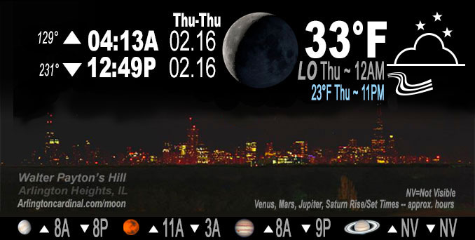
NOTE: Keep in mind lunar rise and set times don’t always correspond with night weather and early morning lows because on some days during the month the moon is visible in the sky predominantly during the daytime hours.
Overnight Wednesday/Thursday …
Weather Hazards expected …
Weather system to bring a wintry mix of precipitation to the area Thursday, including snow, sleet, freezing rain, and rain.
Winter Storm Watch has been upgraded to a Winter Storm Warning for Ogle, Winnebago, Boone, McHenry and Lake counties in Illinois where a swath of 4-7 inches of snow is expected.
Areas between the Warning and I-80 in Illinois have been included in a Winter Weather Advisory where slippery travel due to a combination of snow (1-4″), sleet, and a glaze of ice are possible.
Gusty NNE winds up to 40 mph will result in localized visibility reductions due to blowing snow, especially in the Warning area.
Waves building over southern Lake Michigan could result in minor lakeshore flooding.
Signal for lingering lake effect snow band into northwest Indiana Thursday night with a narrow axis of accumulation possible.
DISCUSSION…
The focus in the short term then quickly turns to our next weather system expected to bring accumulating snow and a wintry mix of precipitation to the area. The energy for this system currently resides over the Four Corners region as a closed upper low. This will begin to lift northeast along the upper jet toward the local area early Thursday morning.
Hello mobile users! If you encounter mobile “unfriendly” weather page, turn your phone sideways for a better view.
======================
O’HARE FORECAST …
Forecast Beginning Wednesday Night, Feb. 15, 2023 …
Wednesday Night: A 20 percent chance of rain after midnight. Mostly cloudy, with a low around 32. Northwest wind 5 to 10 mph becoming northeast 10 to 15 mph after midnight. Winds could gust as high as 25 mph.
Thursday: Snow likely, possibly mixed with rain and sleet, becoming all snow after 3pm. Cloudy, with a high near 37. Breezy, with a north northeast wind 20 to 25 mph, with gusts as high as 40 mph. Chance of precipitation is 70%.
Thursday Night: A 30 percent chance of snow before midnight. Mostly cloudy, with a low around 15. Blustery.
Friday: Sunny, with a high near 27.
Friday Night: Clear, with a low around 20.
Saturday: Mostly sunny, with a high near 45. Breezy.
Saturday Night: Mostly cloudy, with a low around 34.
Sunday: Partly sunny, with a high near 47.
Sunday Night: Mostly cloudy, with a low around 34.
Monday: Washington’s Birthday: Partly sunny, with a high near 47.
O’Hare forecast archive and hourly weather observations archive are available HERE on the CARDINAL NEWS Magazine.
Arlingtoncardinal.com/moonphases
Arlingtoncardinal.com/nightsky
NIGHT SKY THIS MONTH …
Check the night sky objects for this month and past months in the playlist from the Space Telescope Science Institute YouTube channel Backyard stargazers get a monthly guide to the northern hemisphere’s skywatching events with “Tonight’s Sky” (Musical track The Far River written by Jonn Serrie, from the album And the Stars Go With You courtesy of New World Music Ltd. Musical track The Far River written by Jonn Serrie, from the album And the Stars Go With You courtesy of New World Music Ltd).
Telephoto lens, ISO 100, f/11, Shutter Speed 1/100 to 1/125 for the Moon.
Get updates from The Cardinal ALL NEWS FEEDS on Facebook. Just ‘LIKE’ the ‘Arlington Cardinal Page (become a fan of our page). The updates cover all posts and sub-category posts from The Cardinal — Arlingtoncardinal.com. You can also limit feeds to specific categories. See all of The Cardinal Facebook fan pages at Arlingtoncardinal.com/about/facebook …
Help fund The Cardinal Arlingtoncardinal.com/sponsor
Telephoto lens, ISO 1600, f/11, Shutter Speed 2.5″ for the skyline. The skyline exposure was toned down, and brightness and contrast was adjusted in Photoshop.
Area Forecast Discussion
National Weather Service Chicago/Romeoville, IL
911 PM CST Wed Feb 15 2023
.UPDATE… Issued at 911 PM CST Wed Feb 15 2023
Overall the forecast remains mostly on track for the approaching winter system with a potpourri of wintry precipitation expected across the area early Thursday morning through the afternoon before switching over to mostly snow by the evening. Main change in thinking with the latest guidance coming in is that the potential for loss of cloud ice above 600 mb after mid morning is increasing… which could result in loss of cloud ice needed for snow and/or sleet and accordingly increase the potential for freezing drizzle and/or freezing rain. Do think that there will be enough convective elements for sleet to still mix in there at times.
Opted to make some adjustments in the gridded forecast to account for this. It resulted in a slightly sharper drop in snowfall amounts south of I-88 and broader coverage of a light icing for areas between the I-80/I-88 corridor.
The main story remains unchanged however with slippery travel expected during the mid/late morning and afternoon commutes. No changes made to the going headlines other than adding more detailed mention of icing potential in the Winter Weather Advisory.
Petr/NWS Chicago
&&
.SHORT TERM… Issued at 430 PM CST Wed Feb 15 2023
Through Thursday night…
Key Messages:
* Weather system to bring a wintry mix of precipitation to the area Thursday, including snow, sleet, freezing rain, and rain.
* Winter Storm Watch has been upgraded to a Winter Storm Warning for Ogle, Winnebago, Boone, McHenry and Lake counties in Illinois where a swath of 4-7 inches of snow is expected.
* Areas between the Warning and I-80 in Illinois have been included in a Winter Weather Advisory where slippery travel due to a combination of snow (1-4″), sleet, and a glaze of ice are possible.
* Gusty NNE winds up to 40 mph will result in localized visibility reductions due to blowing snow, especially in the Warning area.
* Waves building over southern Lake Michigan could result in minor lakeshore flooding.
* Signal for lingering lake effect snow band into northwest Indiana Thursday night with a narrow axis of accumulation possible.
Through this evening: Quiet weather is in store after breezy westerly winds ease with sunset.
Overview: The focus in the short term then quickly turns to our next weather system expected to bring accumulating snow and a wintry mix of precipitation to the area. The energy for this system currently resides over the Four Corners region as a closed upper low. This will begin to lift northeast along the upper jet toward the local area early Thursday morning. As it does so it merges back into the upper trough becoming positively tilted with a northern stream wave diving toward the area out of south central Canada. As these two waves attempt to phase with each other, the upper jet will enhance across the northern Great Lakes, placing our area beneath the right entrance region and accordingly providing more than sufficient synoptic support for lift.
Looking more closely at a few mesoscale features that play a role in our expectations, the first of which is signal for frontogenesis within the dendritic growth layer, mainly across our northern tier of counties which would be supportive of higher snowfall rates. Secondly there is a signal for a warm nose to orient into the area which would be supportive of melting of snowflakes in the mid-levels just south of that axis. Lastly a notable sub-freezing layer beneath this which could allow for refreezing to sleet or freezing rain.
A sampling of forecast vertical profiles across the area paint a picture of a messy wintry mix of precipitation. This will vary spatially and temporally through the course of the day tomorrow and accordingly will differ depending on your location. More generally, locales along and northwest of a line from Dixon to Waukegan, IL will favor mainly snow through the duration of the event. Locations south of that line and north of a line from Fairbury to Kankakee to Valparaiso will favor a wintry mix for much of the day including a combination of sleet and/or freezing rain ending with snowfall. Our far southeastern forecast area may see predominantly rain with a brief wintry mix late afternoon/ early evening before eventually switching to all snow.
Snowfall amounts: Highest amounts are currently expected along the state line where 4 to 7 inches are forecast. This will begin as a heavy wet snow and we may see melting at onset due to the warm antecedent surface temperatures the past several days. However, due to a combination of the response to frontogenesis and elevated instability, suspect that snowfall rates may not take too long be able to overcome this. For areas between the warning area and along and north of I-80/I-55 could see anywhere from 1 to 4 inches of snow with lesser amounts south of there. Plan on slippery conditions during the morning and afternoon commutes tomorrow!
Though there was a noteworthy difference between some of the hi- res and global guidance in the 12z cycle today (Wednesday), it does appear that 18Z guidance is trying to come into better agreement with the global guidance, though there remain differences in the placement of the snowfall axis. Thus cannot rule out further adjustments to the current headlines a row of counties further south if confidence increases in the placement of the heaviest axis. Another consideration in terms of potential advisory expansion with south and southeastward extent is how quickly temperatures cool Thursday afternoon, which may enable slick conditions during and beyond the Thursday evening commute in parts of the area not currently in the advisory. For a note on the lake effect snow potential, see the Thursday night section.
Gusty Winds and Blowing Snow: On top of any snowfall that falls, a tight surface pressure gradient as the surface low moves across the area could result in wind gusts up to 40 mph at times, peaking in the afternoon and evening hours. Any areas with snowfall that has accumulated on the ground could result in additional visibility reductions due to blowing snow. A much colder air mass moving in will cause the snow Thursday afternoon and evening to be fluffier and more prone to blowing and drifting.
Waves on lake Michigan: Another impact of the wind will be the building of waves over southern Lake Michigan which could result in minor lakeshore flooding. We may need to consider Lakeshore Flood Advisories for a portion of the lakeshore, despite much lower lake levels than a few years ago.
Thursday Night: Snowfall begins to taper off Thursday evening and overnight, with the exception being northwest Indiana where lingering lake effect snow is possible. There still remains some uncertainty with how robust the lake effect snow band will end up. This area has been lift out of headlines with this issuance, though it may be considered if confidence in impactful accumulating snowfall increases in those areas.
Temperatures overnight will continue to drop in the wake of the departing system with lows by early Friday morning in the teens to around 20 degrees.
Petr/NWS Chicago
