
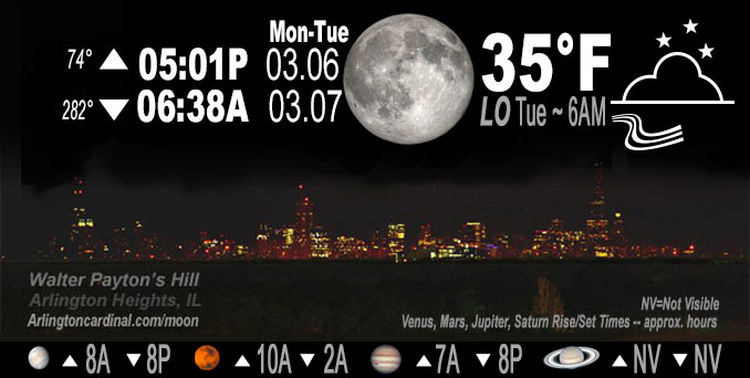
🌔 🌕 🌗 🌑 Waxing Gibbous Moon, sky cover overnight Mon. to Tue. 100% to 85%, winds NNW to NE, 15 to 16 MPH, G25 to 28 MPH, Low 35, 6a to 7a
NWS CHGO | NWS HRLY | /NWSchicago | 🌡
ARLINGTON HEIGHTS WEATHER
▴ forecast7 (Arl. Hts.) | RADAR | WIDE RADAR
IMPORTANT NOTE ON NWS DATA
======================
NIGHT FORECASTS …
NOTE: Keep in mind lunar rise and set times don’t always correspond with night weather and early morning lows because on some days during the month the moon is visible in the sky predominantly during the daytime hours.
Overnight Monday/Tuesday …
No Weather Hazards expected
Turning blustery this evening.
DISCUSSION…
Tuesday … Gusty north-northeast winds all day Tuesday with highs near normal inland, though only upper 30s near the lake.
Hello mobile users! If you encounter a mobile “unfriendly” weather page, turn your phone sideways for a better view.
======================
O’HARE FORECAST …
Forecast Beginning Monday Night, Mar. 06, 2023 …
Monday Night: Cloudy, with a low around 35. North northeast wind around 15 mph, with gusts as high as 25 mph.
Tuesday: Mostly cloudy, then gradually becoming sunny, with a high near 43. Northeast wind around 15 mph, with gusts as high as 30 mph.
Tuesday Night: Mostly cloudy, with a low around 32. East wind 10 to 15 mph, with gusts as high as 20 mph.
Wednesday: Cloudy, then gradually becoming mostly sunny, with a high near 41. East wind 10 to 15 mph.
Wednesday Night: Mostly cloudy, with a low around 32. East wind around 15 mph, with gusts as high as 20 mph.
Thursday: Mostly cloudy, with a high near 41. Breezy.
Thursday Night: Snow, possibly mixed with rain, mainly after midnight. Low around 34. Breezy. Chance of precipitation is 80%.
Friday: Snow likely, mainly before noon. Cloudy, with a high near 40.
Friday Night: Mostly cloudy, with a low around 28.
Saturday: Partly sunny, with a high near 37.
Saturday Night: A chance of snow. Mostly cloudy, with a low around 28.
Sunday: Mostly cloudy, with a high near 37.
Sunday Night: Mostly cloudy, with a low around 29.
Monday: Mostly cloudy, with a high near 38.
O’Hare forecast archive and hourly weather observations archive are available HERE on the CARDINAL NEWS Magazine.
Arlingtoncardinal.com/moonphases
Arlingtoncardinal.com/nightsky
NIGHT SKY THIS MONTH …
Check the night sky objects for this month and past months in the playlist from the Space Telescope Science Institute YouTube channel Backyard stargazers get a monthly guide to the northern hemisphere’s skywatching events with “Tonight’s Sky” (Musical track The Far River written by Jonn Serrie, from the album And the Stars Go With You courtesy of New World Music Ltd. Musical track The Far River written by Jonn Serrie, from the album And the Stars Go With You courtesy of New World Music Ltd).
Telephoto lens, ISO 100, f/11, Shutter Speed 1/100 to 1/125 for the Moon.
Get updates from The Cardinal ALL NEWS FEEDS on Facebook. Just ‘LIKE’ the ‘Arlington Cardinal Page (become a fan of our page). The updates cover all posts and sub-category posts from The Cardinal — Arlingtoncardinal.com. You can also limit feeds to specific categories. See all of The Cardinal Facebook fan pages at Arlingtoncardinal.com/about/facebook …
Help fund The Cardinal Arlingtoncardinal.com/sponsor
Telephoto lens, ISO 1600, f/11, Shutter Speed 2.5″ for the skyline. The skyline exposure was toned down, and brightness and contrast was adjusted in Photoshop.
Area Forecast Discussion
National Weather Service Chicago/Romeoville, IL
521 PM CST Mon Mar 6 2023
.SHORT TERM… Issued at 227 PM CST Mon Mar 6 2023
Through Tuesday night…
Key Messages:
* Turning blustery this evening
* Gusty north-northeast winds Tuesday with highs near normal inland, though only upper 30s near the lake
Low pressure of 1009 mb is over the far southern forecast area as of 230 PM. To the immediate northeast of the low, scattered showers forced in the mid-levels (700 mb frontogenesis) will push east of the area late Monday afternoon. A few showers may develop immediately ahead of the low in the far southeast where there has been some cumulus, but T-Td spreads around 20F should limit mixed-layer CAPE for thunder chances. To the north, trends in sky cover this afternoon have been challenging to forecast, with a narrow stretch of clearing behind the low resulting in a quick temperature jump upwards. The incoming cold advection, however, is accompanied by solid stratus, and accordingly temperatures are dropping across northern locations and that will spread southeast into early evening. North winds will increase within the pressure gradient with gusts of 20-25 mph. Lows will not be that cool due to stratus, and in fact will be above normal with 30-35F forecast.
A more anticyclonic flow pattern will prevail on Tuesday with a wind bending more northeast. Speeds will ease a tad throughout the day, but with the flow being off the lake it will keep lake- adjacent locales in the 30s while inland realizes lower to mid 40s. Guidance is in solid agreement on clearing spreading southwest during the late morning into early afternoon, and upstream trends over Ontario (source region for Monday afternoon) would support that.
MTF/NWS Chicago
226 AM CST Tue Mar 7 2023
.SHORT TERM… Issued at 132 AM CST Tue Mar 7 2023
Through Wednesday…
No significant weather expected in the short term. Seasonably cool temperatures are expected the next 36 hours, though winds off the lake should keep areas near and just inland from the lake should be a few degrees colder today and tomorrow.
Guidance continues to show skies clearing out this morning. Not unusual for guidance to be too fast/aggressive with clearing, but in this case GOES Nighttime Fog RGB does show clearing line marching steadily south toward the area, so generally followed guidance with skies clearing out this morning. Clearing should be somewhat short lived with extensive mid-high level cloudiness expected to overspread the area again this evening.
– Izzi/NWS Chicago
