
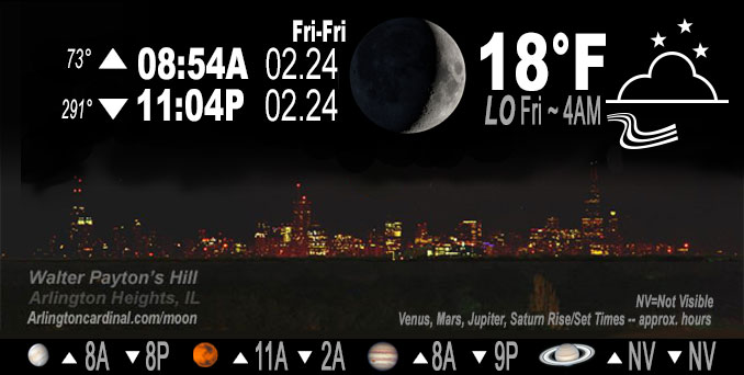
🌒 🌓 🌕 🌗 Waxing Crescent Moon, sky cover overnight Thu. to Fri. 99% to 72% to 54%, winds WNW to NW to NNW, 22 to 16 to 10 MPH, G33 to 29 to 15 MPH end 8a Friday, Low 18, 4a to 7a
NWS CHGO | NWS HRLY | /NWSchicago | 🌡
ARLINGTON HEIGHTS WEATHER
▴ forecast7 (Arl. Hts.) | RADAR | WIDE RADAR
IMPORTANT NOTE ON NWS DATA
======================
NIGHT FORECASTS …
NOTE: Keep in mind lunar rise and set times don’t always correspond with night weather and early morning lows because on some days during the month the moon is visible in the sky predominantly during the daytime hours.
Overnight Thursday/Friday …
No Weather Hazards expected
Cold low temperature of 18°F Friday morning.
DISCUSSION…
Low pressure of 1008 mb over Lake Huron will continue its eastward trek with a tight pressure gradient in its wake ahead of a 1046 mb high across the Northern Plains. This setup in tandem with cold air advection has supported sporadic gusts over 40 mph Thursday. These winds will gradually ease after sundown, though some gustiness will continue much of the evening. There is uncertainty to the rate at which the residual stratocumulus will scatter, but confidence is high at least some holes will develop as the cloud depths are under 1,500 ft and the subsidence inversion is strong.
Hello mobile users! If you encounter mobile “unfriendly” weather page, turn your phone sideways for a better view.
======================
O’HARE FORECAST …
Forecast Beginning Thursday Night, Feb. 23, 2023 …
Thursday Night: Mostly cloudy, with a low around 18. Northwest wind 10 to 15 mph, with gusts as high as 25 mph.
Friday: Partly sunny, with a high near 28. Northwest wind around 10 mph becoming east northeast in the afternoon. Winds could gust as high as 15 mph.
Friday Night: A 20 percent chance of snow before midnight. Mostly cloudy, with a low around 23. East northeast wind 5 to 10 mph becoming light and variable after midnight.
Saturday: Mostly sunny, with a high near 41. Light southwest wind becoming west southwest 5 to 10 mph in the morning.
Saturday Night: Partly cloudy, with a low around 30. Southwest wind 10 to 15 mph, with gusts as high as 25 mph.
Sunday: Mostly sunny, with a high near 49.
Sunday Night: Rain, mainly after midnight. Low around 36. Breezy. Chance of precipitation is 80%.
Monday: Rain. Mostly cloudy, with a high near 52. Breezy.
Monday Night: Mostly cloudy, with a low around 32. Breezy.
Tuesday: Mostly sunny, with a high near 45. Breezy.
Tuesday Night: Mostly cloudy, with a low around 33.
Wednesday: Mostly cloudy, with a high near 49.
Wednesday Night: A chance of rain. Mostly cloudy, with a low around 34.
Thursday: Partly sunny, with a high near 44.
O’Hare forecast archive and hourly weather observations archive are available HERE on the CARDINAL NEWS Magazine.
Arlingtoncardinal.com/moonphases
Arlingtoncardinal.com/nightsky
NIGHT SKY THIS MONTH …
Check the night sky objects for this month and past months in the playlist from the Space Telescope Science Institute YouTube channel Backyard stargazers get a monthly guide to the northern hemisphere’s skywatching events with “Tonight’s Sky” (Musical track The Far River written by Jonn Serrie, from the album And the Stars Go With You courtesy of New World Music Ltd. Musical track The Far River written by Jonn Serrie, from the album And the Stars Go With You courtesy of New World Music Ltd).
Telephoto lens, ISO 100, f/11, Shutter Speed 1/100 to 1/125 for the Moon.
Get updates from The Cardinal ALL NEWS FEEDS on Facebook. Just ‘LIKE’ the ‘Arlington Cardinal Page (become a fan of our page). The updates cover all posts and sub-category posts from The Cardinal — Arlingtoncardinal.com. You can also limit feeds to specific categories. See all of The Cardinal Facebook fan pages at Arlingtoncardinal.com/about/facebook …
Help fund The Cardinal Arlingtoncardinal.com/sponsor
Telephoto lens, ISO 1600, f/11, Shutter Speed 2.5″ for the skyline. The skyline exposure was toned down, and brightness and contrast was adjusted in Photoshop.
Area Forecast Discussion
National Weather Service Chicago/Romeoville, IL
1050 PM CST Thu Feb 23 2023
.SHORT TERM… Issued at 227 PM CST Thu Feb 23 2023
Through Friday night…
Key messages:
* Blustery winds gradually easing this evening, along with some scattering of the clouds
* Chance for brief light snow north of I-80 late in the day Friday into Friday evening
Low pressure of 1008 mb over Lake Huron will continue its eastward trek with a tight pressure gradient in its wake ahead of a 1046 mb high across the Northern Plains. This setup in tandem with cold air advection has supported sporadic gusts over 40 mph today. These winds will gradually ease after sundown, though some gustiness will continue much of the evening. There is uncertainty to the rate at which the residual stratocumulus will scatter, but confidence is high at least some holes will develop as the cloud depths are under 1,500 ft and the subsidence inversion is strong. There might be “low quality” flurries from this cloud deck along and north of I-88 this evening as the cloud layer intersects -7C to -9C. Lake effect clouds are likely into northwest Indiana late tonight into Friday morning and there may be some flurries from these too. Low temperatures tonight will depend on cloud trends, but as it stands lows five degrees below normal are forecast.
The aforementioned high pressure will scoot eastward over the Central Great Lakes on Friday afternoon in this continued progressive pattern, and will yield highs about ten degrees below normal. There will be an equally quick-moving short wave that will be following this high. This will tighten the mid-level baroclinicity of the warm advection zone aloft. This results in some modest frontogenesis (f-gen) and lift within forecast guidance, and a narrow corridor of deeper saturation, but this is atop a very dry boundary layer. So if any precipitation, which would be snow given ice nucleation, it would likely be light. Also this zone is swiftly moving to the east-northeast so residence time of any light snow would be temporary.
MTF/NWS Chicago
