
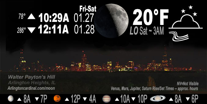
🌒 🌓 🌕 🌗 Waxing Crescent Moon, sky cover overnight Fri. to Sat. 100% to 75% to 100%, winds W to SW to W, 20 to 22 to 3 MPH, G36 to 37 to 15 MPH until 3a, Low 20, 3a to 7a
NWS CHGO | NWS HRLY | /NWSchicago | 🌡
ARLINGTON HEIGHTS WEATHER
▴ forecast7 (Arl. Hts.) | RADAR | WIDE RADAR
IMPORTANT NOTE ON NWS DATA
======================
NIGHT FORECASTS …
NOTE 1: Forecast and information text below may refer to a previous night on Arlingtoncardinal.com, and might not be updated until late afternoon, evening, or overnight. However, Night Sky archives on CARDINAL NEWS Magazine include text forecasts that correspond to the lunar phase graphic above.
NOTE 2: Keep in mind lunar rise and set times don’t always correspond with night weather and early morning lows because on some days during the month the moon is visible in the sky predominantly during the daytime hours.
Overnight Friday/Saturday …
Weather Hazards expected …
Elevated Snow Risk Saturday morning after 9a.
DISCUSSION…
Winds gradually decreasing toward Saturday morning.
Hello mobile users! If you encounter mobile “unfriendly” weather page, turn your phone sideways for a better view.
======================
O’HARE FORECAST …
Forecast Beginning Friday Night, Jan. 27 , 2023 …
Friday Night: Mostly cloudy, with a low around 19. Breezy, with a west wind 15 to 20 mph decreasing to 5 to 10 mph after midnight. Winds could gust as high as 35 mph.
Saturday: Snow, mainly after 9am. High near 29. Light and variable wind becoming north northeast 5 to 10 mph in the morning. Winds could gust as high as 15 mph. Chance of precipitation is 80%. New snow accumulation of 1 to 2 inches possible.
Saturday Night: Snow. Low around 23. North northeast wind 10 to 15 mph, with gusts as high as 20 mph. Chance of precipitation is 90%. New snow accumulation of 1 to 3 inches possible.
Sunday: A 20 percent chance of snow before noon. Mostly cloudy, with a high near 26. North wind 10 to 15 mph, with gusts as high as 25 mph.
Sunday Night: Cloudy, with a low around 13. North northwest wind around 10 mph, with gusts as high as 20 mph.
Monday: Mostly cloudy, with a high near 16.
Monday Night: Partly cloudy, with a low around -3.
Tuesday: Mostly sunny, with a high near 14.
Tuesday Night: Mostly clear, with a low around 6.
Wednesday: Partly sunny, with a high near 21.
Wednesday Night: Mostly cloudy, with a low around 7.
Thursday: Partly sunny, with a high near 21.
Thursday Night: Partly cloudy, with a low around 8.
Friday: Mostly sunny, with a high near 25.
O’Hare forecast archive and hourly weather observations archive are available HERE on the CARDINAL NEWS Magazine.
Arlingtoncardinal.com/moonphases
Arlingtoncardinal.com/nightsky
NIGHT SKY THIS MONTH …
Check the night sky objects for this month and past months in the playlist from the Space Telescope Science Institute YouTube channel Backyard stargazers get a monthly guide to the northern hemisphere’s skywatching events with “Tonight’s Sky” (Musical track The Far River written by Jonn Serrie, from the album And the Stars Go With You courtesy of New World Music Ltd. Musical track The Far River written by Jonn Serrie, from the album And the Stars Go With You courtesy of New World Music Ltd).
Telephoto lens, ISO 100, f/11, Shutter Speed 1/100 to 1/125 for the Moon.
Get updates from The Cardinal ALL NEWS FEEDS on Facebook. Just ‘LIKE’ the ‘Arlington Cardinal Page (become a fan of our page). The updates cover all posts and sub-category posts from The Cardinal — Arlingtoncardinal.com. You can also limit feeds to specific categories. See all of The Cardinal Facebook fan pages at Arlingtoncardinal.com/about/facebook …
Help fund The Cardinal Arlingtoncardinal.com/sponsor
Telephoto lens, ISO 1600, f/11, Shutter Speed 2.5″ for the skyline. The skyline exposure was toned down, and brightness and contrast was adjusted in Photoshop.
Area Forecast Discussion
National Weather Service Chicago/Romeoville, IL
1044 PM CST Fri Jan 27 2023
.UPDATE… Issued at 901 PM CST Fri Jan 27 2023
Updates made in near term this evening to end precipitation, decrease cloud cover into the overnight hours, and tweak tem Ptrends in strong cold advection behind this late afternoon`s cold frontal passage. Looking ahead into Saturday, did slow early morning snow arrival slightly across our northwest based on decent agreement in latest model trends. No changes beyond that time however with little of the 00Z guidance in yet, though it`s not out of the question that higher snow amounts could be focused closer to/north of the IL/WI border with perhaps a higher potential for some mixed precip farther north into the cwa late Saturday/Saturday night.
Mid-evening surface analysis shows cold front has cleared the forecast area to our east and southeast. Had a very brief period of very strong west winds immediately behind the front with 45-50 mph gusts in a few spots, though those have eased to 25-30 mph and expect a continued diminishing trend over the next several hours as surface high pressure ridge across MN/IA/northern MO moves quickly east. Dry low level advection and eastward movement of a mid-level short wave trough axis have allowed lingering rain/snow showers to end across northwest IN, with a considerable amount of clearing across the cwa. Thus removed remaining pops and reduced forecast sky cover across the area through the early overnight hours, before high clouds increase pre-dawn in advance of the next approaching weather system.
That system is noted in evening vapor imagery tracking across the central Rockies, with lee-side surface low pressure yet to consolidate into a low pressure center over KS late tonight. The low is then expected to track along the low level frontal zone which trails southwest of our recent cold front. Trends in 18Z and more recent high-res model guidance (as well as 00Z NAM) slows the arrival of initial light snow into our western cwa by a few hours early Saturday morning, and have made some adjustments to our pops based on these trends. High-res guidance and 00Z NAM generally maintains a slightly farther north position of the surface front and low track across the forecast area Saturday/Saturday evening as compared to 18Z global runs. Given narrow axis of heavier banded snow potential, small differences north or south will have significant impacts on snow amounts and potential for wintry mix/freezing rain across the WFO LOT forecast area. While a slightly farther north track can`t be ruled out, am not planning changes to current forecast and headlines at this time pending a better look at the 00Z suite of global guidance for the night shift.
Ratzer
&&
.SHORT TERM… Issued at 405 PM CST Fri Jan 27 2023
Through Sunday…
Key messages through Sunday are:
* Winds re-increasing early this evening behind a cold front with gusts of 30 to 40 mph and patchy blowing snow in open locations
* Accumulating snow likely Saturday into Saturday night. Highest accumulations (roughly 3-6″ with potential for locally higher totals) expected to occur roughly along and north of the I-88 corridor.
* Winter Weather Advisory issued for locations roughly along and north of the I-88 corridor to highlight the likelihood of higher snow totals there and associated travel impacts.
* Still potential for the heaviest snow axis to shift north towards or into southern Wisconsin, which would limit accumulations and impacts in the NWS Chicago forecast area, or slightly farther south, which may necessitate a southward expansion of the Winter Weather Advisory.
* Probable period of freezing rain south of I-80 Saturday evening into early Sunday morning.
The strong mid-level vorticity maximum that brought arcs of robust snow showers is directly over northeast Illinois and about to exit east. Some of these snow showers were snow squall-like, but one key difference from those times we issue Snow Squall Warnings is that temperatures have been on their way up as opposed to down, with above freezing readings sweeping into the metro as of 230 PM. The last showers will be lighter and likely a mix of rain and wet snow based on upstream observations boundary layer melting energy sufficient for partial to near full melting.
Temperatures of 34 to 40 from north to south across the CWA will be seen until 5 or 6 PM within the speedy warm sector. The system cold front will then sweep east with gusty west-northwest winds in its wake this evening. Observed gusts upstream have overperformed guidance all day, and see no reason within stout cold air advection and pressure rises of 6 to 9 mb per 6 hours that this should not continue. With gusts of 35 to probably 40 mph, especially north of I-80, wile favor patchy shallow blowing snow as the freshest snow from today will not have had time to crust over with such an ephemeral warm up.
Attention then turns towards the forecast for the weekend, which will likely feature an additional bout of wintry precipitation. Our main feature of interest is a shortwave currently over the northern Great Basin that will continue to wheel around the base of a broad longwave trough that encompasses much of Canada and the northern CONUS over the next several hours. As this wave helps spawn precipitation over the central Plains tonight into tomorrow morning, it will being to shear out and weaken before eventually drifting over the southern Great Lakes by tomorrow afternoon. Despite this, a sharpening baroclinic zone over the region, resultant frontogenesis, and relatively favorable jet dynamics should compensate for the diminishing strength of the wave and help maintain the inbound precipitation shield into at least northern portions our forecast area during the daytime on Saturday.
As noted in the previous forecast discussion, there remain more or less two “camps” for where the bulk of the snow will fall: a northern camp composed primarily of higher resolution guidance that keeps most of the higher snow accumulations north of I-90, and a southern camp composed primarily of global models and their associated ensembles that brings the higher snow totals down closer to the I-80 corridor. Some of the northern solutions actually keep most of the accumulating snow north of our CWA altogether, instead favoring southern Wisconsin to see the majority of the snow, but thinking that some of the models advertising this are overestimating the magnitude of warm air advection that will occur on Saturday, which is not necessarily an uncommon thing for these models to do in these kinds of scenarios. The global guidance, for the most part, has remained quite steadfast over the past 24 hours in bringing advisory-level accumulations down to at least the I-88 corridor, which does give us some higher confidence that this will actually turn out to be the case.
Adding an additional complication to the snowfall forecast is the likelihood of mesoscale, frontogenetically-driven bands of heavier snow developing within the broader snow shield. With the strong degree of baroclinicity in the area, it is no surprise that models are showing a fairly pronounced f-gen signal, and with steep lapse rates expected to be present within the dendritic growth zone at the height of the snowfall on Saturday, there remains a fairly decent potential for the snow to “overperform” wherever this mesoscale banding occurs for an extended period of time. Some degree of lake enhancement may also be seen, which may also locally increase totals for locations in our lake-adjacent counties.
With progged 10:1 to 15:1 snow-to-liquid ratios (highest north, where colder thermal profiles will be present), our current forecast, as collaborated with neighboring NWS WFOs and WPC, explicitly advertises 3-6″ snow totals roughly along and north of I- 88 with 2″ totals extending as far south as the I-80 corridor. In reality though, there will likely be a sharper gradient in snow totals that sets up somewhere between I-80 and the Illinois- Wisconsin stateline, though where that ultimately ends up being won`t be known until just hours before the snow begins. Additionally, a stripe or two of 6+” inch accumulations may occur somewhere in northern Illinois or southern Wisconsin, though due to the mesoscale processes involved in generating this heavier snow, can`t really advertise this potential in the forecast grids with any semblance of confidence at this point, but will continue to emphasize this point in our graphical messaging. All in all, while there`s still some wiggle room for where the bulk of the accumulating snowfall may occur and for how high or low snow totals in our forecast area may be, issuing a Winter Weather Advisory for the northern third or so of our CWA felt like the most appropriate thing to do at this point. Hopefully, once precipitation actually develops over the central Plains tonight, observational trends and any emerging trends in forecast guidance will allow the forecast to be refined with higher confidence during our evening updates or our overnight forecast package.
Saturday evening, the aforementioned baroclinic zone and an associated surface front will begin to sag southeastward. As this occurs, a low-level jet that will be nosing northward towards our forecast area and an incoming secondary shortwave should spur the development of additional precipitation within the frontal zone, which will provide areas that missed out on snowfall during the daytime an opportunity to still receive at least a light coating of snow at some point during the nighttime. Warm air overriding colder air behind the surface front may also lead to a corridor of freezing rain materializing somewhere along and south of I-80 Saturday evening into the overnight hours. Ice accretion does not look like it will be significant in terms of overall amounts, but there will still be potential for roads to ice over wherever the freezing rain does occur, so may need to more formally message this potential in forthcoming forecast packages.
Lastly, most precipitation should come to an end by mid-morning Sunday. However, there may still be some lingering lake effect snow showers that produce some additional light snow accumulations into portions of northwest Indiana heading into the afternoon.
Ogorek/MTF/NWS Chicago
