
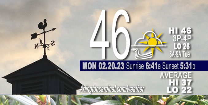
Monday Hi 46, partly cloudy, winds E to SE to SSW to W, 2 to 9 to 17 MPH, G14 to 31 MPH continuing overnight
NWS CHGO | NWS HRLY | /NWSchicago | 🌡
ARLINGTON HEIGHTS WEATHER
▴ forecast7 (Arl. Hts.) | RADAR | WIDE RADAR
⏪ Hrly Data Table | Hrly Future Graph ⏩
IMPORTANT NOTE ON NWS DATA
⏪ Hrly Data Table | Hrly Future Graph ⏩
======================
Monday and Monday Evening …
No Weather Hazards expected …
A clipper system moving across the Dakotas this morning will quickly shift eastward across the Upper Midwest later today, and into the Upper Great Lakes region tonight. This system will push a trailing cold front eastward across our area around, or shortly after midnight tonight.
DISCUSSION…
While conditions will turn colder as blustery northwesterly winds develop in the wake of the front overnight, conditions should remain relatively mild (lower 40s) in advance of the front this evening. Gusty northwest winds (up to 35 mph) overnight will then drive temperatures back down into the 20s into early Tuesday morning. Most, if not all, of precipitation associated with the clipper system will remain north of the area, so we continue a mainly dry forecast for the area through Tuesday.
Daily low temperatures and daily high temperatures are on the way up. We’re gaining about 2 minutes of daylight every day in the progression toward vernal equinox, March 20, 2023. We gained 3 minutes of daylight on Monday, February 20, 2023.
======================
O’HARE FORECAST …
Forecast Beginning Monday, Feb. 20, 2023
Monday Washington’s Birthday: Partly sunny, with a high near 46. Light and variable wind becoming south 5 to 10 mph in the morning.
Monday Night: Mostly cloudy, with a low around 26. Breezy, with a south wind 5 to 10 mph becoming west 15 to 20 mph after midnight. Winds could gust as high as 35 mph.
Tuesday: Increasing clouds, with a high near 36. Breezy, with a west northwest wind 15 to 20 mph becoming south 5 to 10 mph in the afternoon. Winds could gust as high as 30 mph.
Tuesday Night: A slight chance of snow after midnight, mixing with rain after 3am. Cloudy, with a low around 33. East wind 5 to 10 mph increasing to 10 to 15 mph after midnight. Winds could gust as high as 25 mph. Chance of precipitation is 20%.
Wednesday: Rain, mainly after noon. High near 36. Breezy, with an east northeast wind 15 to 25 mph, with gusts as high as 35 mph. Chance of precipitation is 90%.
Wednesday Night: Rain before 3am, then a chance of rain or freezing rain. Low around 34. Breezy. Chance of precipitation is 100%.
Thursday: A chance of rain and snow before noon, then a slight chance of snow. Mostly cloudy, with a high near 44. Breezy. Chance of precipitation is 30%.
Thursday Night: Mostly cloudy, with a low around 17. Breezy.
Friday: Partly sunny, with a high near 27.
Friday Night: A chance of snow. Mostly cloudy, with a low around 24.
Saturday: Partly sunny, with a high near 42.
Saturday Night: Partly cloudy, with a low around 29.
Sunday: Mostly sunny, with a high near 44.


CHICAGOWEATHERSTATION.COM

ChicagoWeatherStation.com I O’Hare Normal Temps/Precip I O’Hare Record Temps, Precip, Snow
LIVE RADAR | STORM TRACKS | UNISYS US IR SAT | UNISYS Midwest IR SAT | UNISYS More IR SAT
WunderMap® with Temperature/Wind Data || Google: Arlington Heights Area Temps | US TEMPS
Full Screen Motion Weather Radar (Wunderground.com)
Midwest Cloud Cover with Arlington Heights Weather Forecast
ChicagoWeatherStation.com I O’Hare Normal Temps/Precip I O’Hare Record Temps, Precip, Snow
SUNLIGHT DATA FOR SECURITY, TRAFFIC SAFETY, AND SPORTS
SunCalc.net data with solar azimuth and trajectory, times for dawn, sunrise, solar noon, sunset, dusk …
NIGHT SKY THIS MONTH …
Backyard stargazers get a monthly guide to the northern hemisphere’s skywatching events with “Tonight’s Sky.” Check the night sky objects for this month and past months in the playlist from the Space Telescope Science Institute YouTube channel (Musical track The Far River written by Jonn Serrie, from the album And the Stars Go With You courtesy of New World Music Ltd).
Get updates from The Cardinal ALL NEWS FEEDS on Facebook. Just ‘LIKE’ the ‘Arlington Cardinal Page (become a fan of our page). The updates cover all posts and sub-category posts from The Cardinal — Arlingtoncardinal.com. You can also limit feeds to specific categories. See all of The Cardinal Facebook fan pages at Arlingtoncardinal.com/about/facebook …
Help fund The Cardinal Arlingtoncardinal.com/sponsor
Area Forecast Discussion
National Weather Service Chicago/Romeoville, IL
552 AM CST Mon Feb 20 2023
.SHORT TERM… Issued at 344 AM CST Mon Feb 20 2023
Through Tuesday…
Winds have turned northerly across the area in the wake of a weak cold frontal passage. While a slightly cooler airmass is working southward into the area and resulting in subfreezing temperatures across parts of the area early this morning, temperatures look to rebound nicely today. We should see the winds go light and variable for a period this morning before they settle back to a southerly direction this afternoon. This should help temperatures rebound back into the 40s this afternoon under partly sunny skies.
A clipper system moving across the Dakotas this morning will quickly shift eastward across the Upper Midwest later today, and into the Upper Great Lakes region tonight. This system will push a trailing cold front eastward across our area around, or shortly after midnight tonight. While conditions will turn colder as blustery northwesterly winds develop in the wake of the front overnight, conditions should remain relatively mild (lower 40s) in advance of the front this evening. Gusty northwest winds (up to 35 mph) overnight will then drive temperatures back down into the 20s into early Tuesday morning. Most, if not all, of precipitation associated with the clipper system will remain north of the area, so we continue a mainly dry forecast for the area through Tuesday.
Winds will abate across the area during the day Tuesday as a weak surface high quickly shifts across the area in advance of the next storm system expected to impact the region Wednesday into Thursday. Expect high temperatures Tuesday to be cooler, with readings likely to range from the lower 30s far north, to around 40 far south.
KJB/NWS Chicago
