
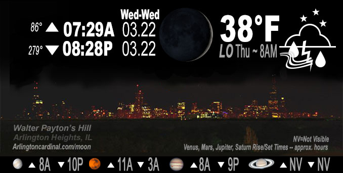
🌒 🌓 🌕 🌗 Waxing Crescent Moon, chance thundershower, sky cover overnight Wed. to Thu. 98% to 90% to 92%, winds SW to N to NE, 3 to 13 MPH, G14 to 21 to 18 MPH Low 38, 8a to 9a
NWS CHGO | NWS HRLY | /NWSchicago | 🌡
ARLINGTON HEIGHTS WEATHER
▴ forecast7 (Arl. Hts.) | RADAR | WIDE RADAR
IMPORTANT NOTE ON NWS DATA
Hello mobile users! If you encounter a mobile “unfriendly” weather page, turn your phone sideways for a better view.
======================
NIGHT FORECASTS …
NOTE: Keep in mind lunar rise and set times don’t always correspond with night weather and early morning lows because on some days during the month the moon is visible in the sky predominantly during the daytime hours.
Overnight Wednesday/Thursday …
Weather Hazards expected
Elevated Thunderstorm Risk…with an associated …
Limited hail risk…up to 1 inch. (Primarily South, north Chicagoland not so sure)
DISCUSSION…
Scattered thunderstorms are expected this afternoon and tonight. In addition to cloud to ground lightning and heavy downpours, the strongest storms may produce hail up to 1 inch in diameter, which is large enough to dent siding. The greatest damaging hail threat appears to be along and south of the I-80 corridor.
======================
O’HARE FORECAST …
Forecast Beginning Wednesday Night, Mar. 22, 2023 …
Wednesday Night: Showers and thunderstorms likely, then showers and possibly a thunderstorm after 3am. Patchy fog after 11pm. Low around 38. South wind 5 to 10 mph becoming north northeast after midnight. Chance of precipitation is 80%. New rainfall amounts between a tenth and quarter of an inch, except higher amounts possible in thunderstorms.
Thursday: Showers and thunderstorms before 11am, then isolated showers between 11am and 2pm. High near 41. North northeast wind 10 to 15 mph, with gusts as high as 20 mph. Chance of precipitation is 80%. New precipitation amounts of less than a tenth of an inch, except higher amounts possible in thunderstorms.
Thursday Night: Mostly cloudy, with a low around 34. Northeast wind 5 to 10 mph.
Friday: A 10 percent chance of rain after 5pm. Mostly cloudy, with a high near 43. East northeast wind 10 to 15 mph.
Friday Night: Rain before 5am, then rain, possibly mixed with snow. Low around 35. Chance of precipitation is 90%.
Saturday: Rain and snow, mainly before 2pm. High near 41. Breezy. Chance of precipitation is 90%.
Saturday Night: A chance of rain and snow before 8pm. Partly cloudy, with a low around 30.
Sunday: Mostly sunny, with a high near 50.
Sunday Night: A chance of rain after 2am. Mostly cloudy, with a low around 35.
Monday: A chance of rain. Mostly cloudy, with a high near 45.
Monday Night: Partly cloudy, with a low around 32.
Tuesday: Mostly sunny, with a high near 46.
Tuesday Night: Partly cloudy, with a low around 31.
Wednesday: Mostly sunny, with a high near 50.
O’Hare forecast archive and hourly weather observations archive are available HERE on the CARDINAL NEWS Magazine.
Arlingtoncardinal.com/moonphases
Arlingtoncardinal.com/nightsky
NIGHT SKY THIS MONTH …
Check the night sky objects for this month and past months in the playlist from the Space Telescope Science Institute YouTube channel Backyard stargazers get a monthly guide to the northern hemisphere’s skywatching events with “Tonight’s Sky” (Musical track The Far River written by Jonn Serrie, from the album And the Stars Go With You courtesy of New World Music Ltd. Musical track The Far River written by Jonn Serrie, from the album And the Stars Go With You courtesy of New World Music Ltd).
Telephoto lens, ISO 100, f/11, Shutter Speed 1/100 to 1/125 for the Moon.
Get updates from The Cardinal ALL NEWS FEEDS on Facebook. Just ‘LIKE’ the ‘Arlington Cardinal Page (become a fan of our page). The updates cover all posts and sub-category posts from The Cardinal — Arlingtoncardinal.com. You can also limit feeds to specific categories. See all of The Cardinal Facebook fan pages at Arlingtoncardinal.com/about/facebook …
Help fund The Cardinal Arlingtoncardinal.com/sponsor
Telephoto lens, ISO 1600, f/11, Shutter Speed 2.5″ for the skyline. The skyline exposure was toned down, and brightness and contrast was adjusted in Photoshop.
/////////////>
Area Forecast Discussion
National Weather Service Chicago/Romeoville, IL
336 PM CDT Wed Mar 22 2023
.SHORT TERM… Issued at 246 PM CDT Wed Mar 22 2023
Through Thursday night…
An existing area of showers with embedded storms within the nose of a 700-800 hPa speed max entering the central CWA will continue to track ENE through the next few hours, brushing the south half of the Chicago metro. Small but strong cores embedded in this cluster may produce small hail.
In the absence of stronger mid-level forcing this evening, strengthening low-level moisture transport and F-gen across the southern CWA combined with ongoing isentropic ascent should foster at least isolated to scattered showers and thunderstorms east of I-55 through the early morning hours. Some 700-750hPa warming should inhibit greater coverage of convection during this time, but a couple storms may become strong enough to produce small hail.
Focus then turns toward a subtle low to mid-level wave propogating from the southern High Plains this afternoon into Illinois by the pre-dawn hours Thursday. Remaining conditional instability should be realize as mid-level cooling erodes the noted 700 hPa capping. A resultant conglomerate of convection moving across the forecast area continues to become more likely in the 3a-9a window. Effective shear profiles and MUCAPE values approaching 750-1000 J/kg (primarily south of the Chicago metro) will produce an increased risk of hail with more robust convective cores during this time. As long as shower/convective coverage does not become too widespread, discrete cells will favor elevated supercells capable of producing severe hail.
Shower storm coverage will diminish from west to east across northern Illinois after daybreak as a strengthening cold front drifts south of the CWA through tonight. The northern periphery of widespread rain over the Ohio River Valley may brush our far southern CWA during this time, but trends in guidance over the past couple days continue to favor a drier period.
Kluber/NWS Chicago
