
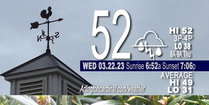
Wednesday Hi 52, mostly cloudy, chance showers after 6p, winds S to SW to NW, 7 to 12 to 3 MPH
NWS CHGO | NWS HRLY | /NWSchicago | 🌡
ARLINGTON HEIGHTS WEATHER
▴ forecast7 (Arl. Hts.) | RADAR | WIDE RADAR
⏪ Hrly Data Table | Hrly Future Graph ⏩
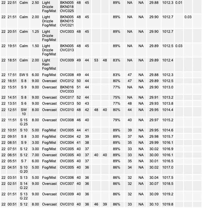
IMPORTANT NOTE ON NWS DATA
⏪ Hrly Data Table | Hrly Future Graph ⏩
Hello mobile users! If you encounter a mobile “unfriendly” weather page, turn your phone sideways for a better view.
======================
Wednesday and Wednesday Evening …
Weather Hazards expected …
Elevated Thunderstorm Risk…with an associated …
Limited hail risk…up to 1 inch.
DISCUSSION…
Scattered thunderstorms are expected this afternoon and tonight. In addition to cloud to ground lightning and heavy downpours, the strongest storms may produce hail up to 1 inch in diameter, which is large enough to dent siding. The greatest damaging hail threat appears to be along and south of the I-80 corridor.
======================
O’HARE FORECAST …
Forecast Beginning Wednesday, Mar. 22, 2023
Wednesday: Showers likely and possibly a thunderstorm. Cloudy, with a high near 50. South southwest wind around 10 mph, with gusts as high as 15 mph. Chance of precipitation is 60%. New rainfall amounts of less than a tenth of an inch, except higher amounts possible in thunderstorms.
Wednesday Night: Showers and thunderstorms likely, then showers and possibly a thunderstorm after 3am. Patchy fog after 11pm. Low around 38. South wind 5 to 10 mph becoming north northeast after midnight. Chance of precipitation is 80%. New rainfall amounts between a tenth and quarter of an inch, except higher amounts possible in thunderstorms.
Thursday: Showers and thunderstorms before 11am, then isolated showers between 11am and 2pm. High near 41. North northeast wind 10 to 15 mph, with gusts as high as 20 mph. Chance of precipitation is 80%. New precipitation amounts of less than a tenth of an inch, except higher amounts possible in thunderstorms.
Thursday Night: Mostly cloudy, with a low around 34. Northeast wind 5 to 10 mph.
Friday: A 10 percent chance of rain after 5pm. Mostly cloudy, with a high near 43. East northeast wind 10 to 15 mph.
Friday Night: Rain before 5am, then rain, possibly mixed with snow. Low around 35. Chance of precipitation is 90%.
Saturday: Rain and snow, mainly before 2pm. High near 41. Breezy. Chance of precipitation is 90%.
Saturday Night: A chance of rain and snow before 8pm. Partly cloudy, with a low around 30.
Sunday: Mostly sunny, with a high near 50.
Sunday Night: A chance of rain after 2am. Mostly cloudy, with a low around 35.
Monday: A chance of rain. Mostly cloudy, with a high near 45.
Monday Night: Partly cloudy, with a low around 32.
Tuesday: Mostly sunny, with a high near 46.
Tuesday Night: Partly cloudy, with a low around 31.
Wednesday: Mostly sunny, with a high near 50.


CHICAGOWEATHERSTATION.COM

ChicagoWeatherStation.com I O’Hare Normal Temps/Precip I O’Hare Record Temps, Precip, Snow
LIVE RADAR | STORM TRACKS | UNISYS US IR SAT | UNISYS Midwest IR SAT | UNISYS More IR SAT
WunderMap® with Temperature/Wind Data || Google: Arlington Heights Area Temps | US TEMPS
Full Screen Motion Weather Radar (Wunderground.com)
Midwest Cloud Cover with Arlington Heights Weather Forecast
ChicagoWeatherStation.com I O’Hare Normal Temps/Precip I O’Hare Record Temps, Precip, Snow
SUNLIGHT DATA FOR SECURITY, TRAFFIC SAFETY, AND SPORTS
SunCalc.net data with solar azimuth and trajectory, times for dawn, sunrise, solar noon, sunset, dusk …
NIGHT SKY THIS MONTH …
Backyard stargazers get a monthly guide to the northern hemisphere’s skywatching events with “Tonight’s Sky.” Check the night sky objects for this month and past months in the playlist from the Space Telescope Science Institute YouTube channel (Musical track The Far River written by Jonn Serrie, from the album And the Stars Go With You courtesy of New World Music Ltd).
Get updates from The Cardinal ALL NEWS FEEDS on Facebook. Just ‘LIKE’ the ‘Arlington Cardinal Page (become a fan of our page). The updates cover all posts and sub-category posts from The Cardinal — Arlingtoncardinal.com. You can also limit feeds to specific categories. See all of The Cardinal Facebook fan pages at Arlingtoncardinal.com/about/facebook …
Help fund The Cardinal Arlingtoncardinal.com/sponsor
/////////////>
Area Forecast Discussion
National Weather Service Chicago/Romeoville, IL
711 AM CDT Wed Mar 22 2023
.SHORT TERM… Issued at 358 AM CDT Wed Mar 22 2023
Through Thursday…
Main forecast points:
* Periods of scattered showers and thunderstorms into Thursday morning. Greatest chances of thunderstorms appear to be this afternoon along/south of I-80, and from after midnight into early Thursday morning along/south of I-88. Some of these storms may produce damaging hail and frequent lightning. See SPC day 1 and 2 marginal severe outlook.
* Tight temperature gradient develops tonight along a warm front which sets up south of I-80 tonight, with temperatures in the 40s north and near 60 far south.
* Cold front sags across the area Thursday morning, with cooler with daytime temps mainly in the 40s, and some upper 30s along Lake Michigan.
Early morning surface map places low pressure over Minnesota, with a cold front trailing into the Texas/Oklahoma Panhandle regions. In the mid and upper levels, a broad region of west-southwest flow was in place across the Plains and Midwest. A series of small-amplitude short waves will transit this flow through Thursday, while the surface cold front slowly pushes southeast and eventually moves slowly across the forecast area. The first of these waves was evident in satellite vapor imagery early this morning, over northeast KS/NE/western IA. CAM guidance is in good agreement in showers developing from northern MO into central/northern IL through midday, with areas south of the I-88 corridor most likely to be impacted. While this disturbance shifts east of the area later this afternoon, a strengthening upper level jet downstream of a western CONUS upper trough will aid in increasing low-mid level southwest flow, and a developing warm front extending from surface low pressure wave over eastern KS into central/northern IL. Increasing warm/moist advection atop the warm frontal inversion is expected to support additional elevated convective development across the southern half or so of the cwa this afternoon, within an environment characterized by steep mid-level lapse rates which may support some strong updrafts and the potential for isolated damaging hail.
Showers and embedded thunderstorms may persist into this evening within the persistent warm advection ascent above the warm frontal slope, though greatest coverage and the highest thunder chances appear to come after 2-3 AM as another mid-level wave approaches the region. These storms will also have the potential for producing isolated damaging hail, before coverage again diminishes around/just after sunrise. Additional shower and thunderstorm focus will then shift south of I-80 by Thursday afternoon, as the surface cold front pushes through the area.
Extensive cloud cover will work to limit temperatures somewhat today, though highs should still reach the low-mid 50s north and the upper 50s far south late. The front will push into the forecast area tonight, dropping temperatures into the 30s/40s far northwest, and these cooler temperatures will edge further south Thursday behind the front with most areas in the 40s by afternoon. Breezy north- northeast winds off of the lake will likely keep immediate lakeshore areas around 40.
Ratzer/NWS Chicago
