
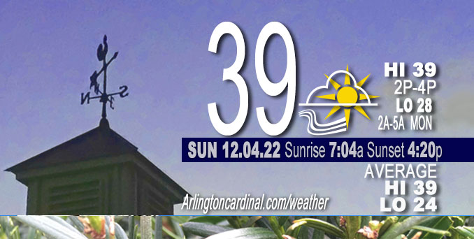
SUNDAY Hi 39, mostly sunny, winds WSW to SW, 10 to 13 to 10 MPH, G17 to 22 to 17 MPH
NWS CHGO | NWS HRLY | /NWSchicago | 🌡
ARLINGTON HEIGHTS WEATHER
▴ forecast7 (Arl. Hts.) | RADAR | WIDE RADAR
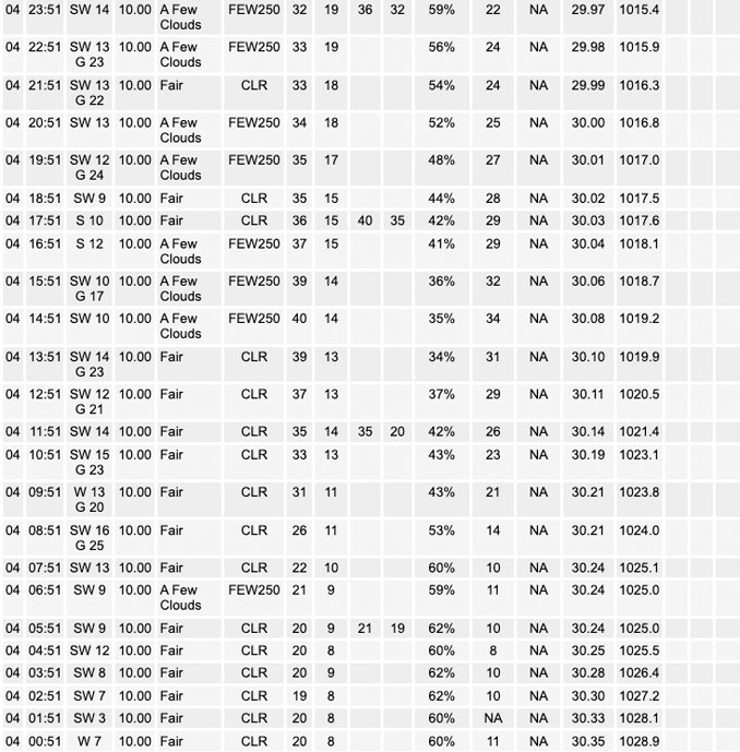
⏪ Hrly Data Table | Hrly Future Graph ⏩
IMPORTANT NOTE ON NWS DATA
⏪ Hrly Data Table | Hrly Future Graph ⏩
======================
Sunday and Sunday Night …
No Weather Hazards expected…
DISCUSSION…
Quiet weather with moderating temperatures are expected Sunday into Monday. Sunday will be Sunny and about 10 degrees warmer than yesterday, but will remain windy. The only real weather consideration is low chances of light rain or drizzle Monday afternoon.
At around 5:30 a.m. Sunday at the surface level, an elongated area of high pressure stretched from the southern Plains through the Ohio Valley, with a 1032 mb center over far southern Illinois. The high pressure is slowly moving east.
Hello mobile users! If you encounter mobile “unfriendly” weather page, turn your phone sideways for a better view.
======================
O’HARE FORECAST …
Forecast Beginning Sunday, Dec. 04, 2022
Sunday: Sunny, with a high near 39. West southwest wind 10 to 15 mph, with gusts as high as 20 mph.
Sunday Night: Increasing clouds, with a low around 28. Southwest wind around 10 mph, with gusts as high as 15 mph.
Monday: Mostly cloudy, with a high near 44. South southwest wind around 10 mph, with gusts as high as 20 mph.
Monday Night: Mostly cloudy, with a low around 30. South southwest wind 5 to 10 mph becoming north after midnight.
Tuesday: A 20 percent chance of rain after noon. Mostly cloudy, with a high near 42. Northeast wind 5 to 10 mph, with gusts as high as 15 mph.
Tuesday Night: A 30 percent chance of rain, mainly before midnight. Mostly cloudy, with a low around 32.
Wednesday: Partly sunny, with a high near 44.
Wednesday Night: Mostly cloudy, with a low around 34.
Thursday: A chance of rain. Mostly cloudy, with a high near 43.
Thursday Night: A chance of rain. Mostly cloudy, with a low around 34.
Friday: Mostly cloudy, with a high near 41.
Friday Night: Mostly cloudy, with a low around 31.
Saturday: A chance of rain. Partly sunny, with a high near 41.


CHICAGOWEATHERSTATION.COM

ChicagoWeatherStation.com I O’Hare Normal Temps/Precip I O’Hare Record Temps, Precip, Snow
LIVE RADAR | STORM TRACKS | UNISYS US IR SAT | UNISYS Midwest IR SAT | UNISYS More IR SAT
WunderMap® with Temperature/Wind Data || Google: Arlington Heights Area Temps | US TEMPS
Full Screen Motion Weather Radar (Wunderground.com)
Midwest Cloud Cover with Arlington Heights Weather Forecast
ChicagoWeatherStation.com I O’Hare Normal Temps/Precip I O’Hare Record Temps, Precip, Snow
SUNLIGHT DATA FOR SECURITY, TRAFFIC SAFETY, AND SPORTS
SunCalc.net data with solar azimuth and trajectory, times for dawn, sunrise, solar noon, sunset, dusk …
NIGHT SKY THIS MONTH …
Backyard stargazers get a monthly guide to the northern hemisphere’s skywatching events with “Tonight’s Sky.” Check the night sky objects for this month and past months in the playlist from the Space Telescope Science Institute YouTube channel (Musical track The Far River written by Jonn Serrie, from the album And the Stars Go With You courtesy of New World Music Ltd).
Get updates from The Cardinal ALL NEWS FEEDS on Facebook. Just ‘LIKE’ the ‘Arlington Cardinal Page (become a fan of our page). The updates cover all posts and sub-category posts from The Cardinal — Arlingtoncardinal.com. You can also limit feeds to specific categories. See all of The Cardinal Facebook fan pages at Arlingtoncardinal.com/about/facebook …
Help fund The Cardinal Arlingtoncardinal.com/sponsor
Area Forecast Discussion
National Weather Service Chicago/Romeoville, IL
Issued at 155 AM CST Sun Dec 4 2022
Through Monday…
Quiet weather with moderating temperatures are expected into Monday. Only real weather concern is low chances of light rain or drizzle Monday afternoon. At this time have maintained dry forecast except for northwest Indiana.
Current GOES vapor imagery and 00Z upper air analysis depicts fast, largely zonal flow across the Midwest early this morning. The core of the upper jet was overhead, with DVN and ILX`s evening RAOBs sampling 155-165 kt just above the tropopause. At the surface, an elongated area of high pressure stretched from the southern Plains through the Ohio Valley, with a 1032 mb center over far southern Illinois. Farther north, deep low pressure was located over northern Saskatchewan. A series of sheared mid-level short wave features will track north of the jet axis across southern Canada through today, with the aforementioned surface low eventually passing north of Lake Superior tonight. Meanwhile, the surface high over the Ohio Valley will slowly move east. Between these areas of lower and higher pressure, warm advection was already underway (above our stable boundary layer at least) within a breezy west-southwest wind regime aloft. Other than some high jet-induced cirrus across the far southern cwa this morning, our dry atmosphere will again allow for plentiful sunshine across the area today. Southwest surface winds and warm advection will combine with the December sun to moderate temps into the upper 30s/around 40 by this afternoon. Southwest winds gusting 15-20 mph will still make it feel a little chillier however with wind chills in the lower 30s.
As the elongated area of surface high pressure to our south moves east tonight, and a surface cold front trails the low north of Lake Superior across the upper Mississippi Valley and Plains, some moisture return will begin to develop south and southwest of our region. This will initially work its way into the Midwest as an increase in mid and high level cloud cover late tonight into Monday morning. Thus after clear evening skies, we will see an increase in high clouds after midnight. Low level moisture looks to arrive during the day Monday, ahead of the aforementioned cold front which will move into the western parts of the cwa late in the day. Various model forecast soundings differ with the depiction of the depth of the low-level moisture layer, but even the most robust guidance depicts this moisture generally below 800-850 mb. NAM-based guidance would potentially support a deep enough cloud layer for some patchy drizzle to develop by afternoon, though the NAM-based models generally have a higher low level moisture bias and other guidance generally depicts a shallower saturated layer. HREF ensemble max QPF (less than 0.10″) generally focuses chances for any light precip north of the area across Wisconsin, and across our far southeast counties from parts of central Illinois into northern Indiana. Thus will maintain a generally dry forecast for most of the area, but will carry some slight chance pops for light rain east of the IL/IN border Monday afternoon. Though cloud cover will be thickening across the area Monday, persistent low level warm advection should support temps further moderating into the low-mid 40s across the area.
Ratzer/NWS Chicago
