
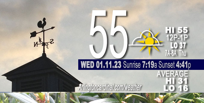
Wednesday Hi 50, mostly cloudy, winds SE to S to E to NE, 6 to 8 to 3 to 5 MPH
NWS CHGO | NWS HRLY | /NWSchicago | 🌡
ARLINGTON HEIGHTS WEATHER
▴ forecast7 (Arl. Hts.) | RADAR | WIDE RADAR
⏪ Hrly Data Table | Hrly Future Graph ⏩
IMPORTANT NOTE ON NWS DATA
⏪ Hrly Data Table | Hrly Future Graph ⏩
======================
Wednesday and Wednesday Night …
No Weather Hazards expected…
Another March-like day today, with temps over-performing into the mid 50s from the Kankakee River Valley into the Chicago. Sunshine early through thin mid-level clouds.
DISCUSSION…
Near term focus is a storm system which will move through the Midwest late tonight through Thursday. Model guidance has continued the trend toward a more southerly low track along the Ohio Valley, as well as delaying the mid level wave`s phasing with northern stream energy until the system is well east of the area. The results of this include shifting the heavier Quantitative Precipitation Forecast (QPF) axis southeast of the Chicagoland forecast area, greatly limiting the amount of precipitation across the IL/WI border region and limiting the potential for a change over from rain to any substantial accumulating wet snow.
======================
O’HARE FORECAST …
Forecast Beginning Wednesday, Jan. 11, 2023
Wednesday: Mostly cloudy, with a high near 54. East wind around 5 mph.
Wednesday Night: Cloudy, with a low around 37. North northeast wind 5 to 10 mph becoming north 10 to 15 mph after midnight. Winds could gust as high as 20 mph.
Thursday: A slight chance of rain before 3pm, then a chance of rain and snow. Cloudy, with a high near 39. North wind around 15 mph, with gusts as high as 30 mph. Chance of precipitation is 30%.
Thursday Night: Scattered snow showers, mainly before midnight. Cloudy, with a low around 29. North northwest wind around 15 mph, with gusts as high as 25 mph. Chance of precipitation is 30%.
Friday: A chance of flurries before noon. Mostly cloudy, with a high near 32. North northwest wind around 15 mph, with gusts as high as 25 mph.
Friday Night: Partly cloudy, with a low around 22.
Saturday: Mostly sunny, with a high near 39.
Saturday Night: Mostly cloudy, with a low around 30.
Sunday: Mostly cloudy, with a high near 44.
Sunday Night: A chance of showers after midnight. Cloudy, with a low around 40.
M.L.King Day: Showers. Cloudy, with a high near 50.
Monday Night: Showers likely. Cloudy, with a low around 40.
Tuesday: Mostly cloudy, with a high near 44.


CHICAGOWEATHERSTATION.COM

ChicagoWeatherStation.com I O’Hare Normal Temps/Precip I O’Hare Record Temps, Precip, Snow
LIVE RADAR | STORM TRACKS | UNISYS US IR SAT | UNISYS Midwest IR SAT | UNISYS More IR SAT
WunderMap® with Temperature/Wind Data || Google: Arlington Heights Area Temps | US TEMPS
Full Screen Motion Weather Radar (Wunderground.com)
Midwest Cloud Cover with Arlington Heights Weather Forecast
ChicagoWeatherStation.com I O’Hare Normal Temps/Precip I O’Hare Record Temps, Precip, Snow
SUNLIGHT DATA FOR SECURITY, TRAFFIC SAFETY, AND SPORTS
SunCalc.net data with solar azimuth and trajectory, times for dawn, sunrise, solar noon, sunset, dusk …
NIGHT SKY THIS MONTH …
Backyard stargazers get a monthly guide to the northern hemisphere’s skywatching events with “Tonight’s Sky.” Check the night sky objects for this month and past months in the playlist from the Space Telescope Science Institute YouTube channel (Musical track The Far River written by Jonn Serrie, from the album And the Stars Go With You courtesy of New World Music Ltd).
Get updates from The Cardinal ALL NEWS FEEDS on Facebook. Just ‘LIKE’ the ‘Arlington Cardinal Page (become a fan of our page). The updates cover all posts and sub-category posts from The Cardinal — Arlingtoncardinal.com. You can also limit feeds to specific categories. See all of The Cardinal Facebook fan pages at Arlingtoncardinal.com/about/facebook …
Help fund The Cardinal Arlingtoncardinal.com/sponsor
Area Forecast Discussion
National Weather Service Chicago/Romeoville, IL
623 AM CST Wed Jan 11 2023
.SHORT TERM… Issued at 345 AM CST Wed Jan 11 2023
Through Thursday night…
Near term focus remains on a storm system which will move through the Midwest late tonight through Thursday. Model guidance has continued the trend toward a more southerly low track along the Ohio Valley, as well as delaying the mid level wave`s phasing with northern stream energy until the system is well east of the area. The results of this include shifting the heavier QPF axis southeast of the forecast area, greatly limiting the amount of precipitation across the IL/WI border region and limiting the potential for a change over from rain to any substantial accumulating wet snow.
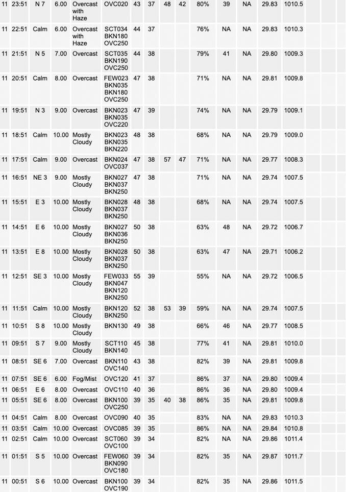
Before we get to the main system, a broad area of mid-level warm advection was occurring across the region early this morning in association with a pair of mid-level waves transiting the upper Midwest and mid-Mississippi Valley region. Regional radar mosaic depicts a northwest-southwest of returns associated from this warm advection flow from Minnesota southeast to northeast IL/Lake Michigan as of 3 AM. Have noted a couple of sprinkles reported from north of O`Hare into the northern suburbs over the past hour or two, but for the most part the radar returns over the WFO LOT area are virga from 10-12 kft cloud bases. 00Z RAOBs from DVN, ILX and other upstream locations to our west/southwest depict significant dry air below about 650-600 mb, so this trend of precip not reaching the ground is expected to continue early this morning before the main forcing shifts east/northeast of the area. Farther to our south, an area of low stratus was evident in GOES IR and surface obs spreading northeast ahead of a weak surface trough from AR/MO/TN into southern IL. Low level moisture progs indicate this will reach our southern cwa counties by midday and will continue to lift across our southeast counties this afternoon. This may be accompanied by some patchy fog and perhaps some spotty light drizzle as well, mainly along/east of the I-55/I-57 corridors. Otherwise, despite cloud cover temps should gradually rise into the mid and upper 40s this afternoon as low level warm/moist advection continues.
Looking out west, the mid-level wave we`ve been watching closely for the past several days was propagating into the central/southern Rockies per water vapor imagery early this morning. Guidance is in good agreement in this wave tracking toward the lower Ohio and Tennessee valleys by Thursday morning, then eventually phasing with a northern stream upper trough across the eastern Lakes Thursday evening. Rain is expected to develo Palong the northern flank of the system from northern MO into IL and mainly the southeast half of the WFO forecast area after midnight tonight, and persist into Thursday before gradually ending from northwest to southeast during the afternoon as the low pulls away to the east. While the best large scale forcing looks to remain south and southeast of the area, several models are depicting a relatively narrow frontogenetically forced band of precip across the southeast cwa Thursday morning. This could produce a narrower ribbon of better rainfall along/just south of the I-80 corridor. Parts of northern IL north of the I-88 corridor may not see much precipitation at all.
North-northwest winds will increase during the day Thursday, becoming blustery by afternoon and pulling colder air into the region. Rain may mix/change to snow from northwest to southeast, though it looks like meaningful precip will likely be ending by the time the column cools sufficiently. A secondary mid-level vort will drop south across the area Thursday evening/night, and this will likely support some light rain/snow showers downwind of Lake Michigan into northwest IN, and a few flurries across northern IL. Low inversion heights should make for poor quality snow and little accumulation is expected with the lake effect. Blustery and colder conditions will continue overnight, with temperatures settling into the mid-20s in most spots and around 30 downwind of Lake Michigan in IN.
Ratzer/NWS Chicago
