
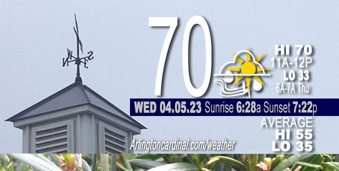
Wednesday Hi 70, thunderstorms early, mostly cloudy to partly sunny, winds S to SW to W, 18 to 28 to 15 MPH, G28 to 40 to 25 MPH, continuing Thursday
NWS CHGO | NWS HRLY | /NWSchicago | 🌡
ARLINGTON HEIGHTS WEATHER
▴ forecast7 (Arl. Hts.) | RADAR | WIDE RADAR
⏪ Hrly Data Table | Hrly Future Graph ⏩
IMPORTANT NOTE ON NWS DATA
⏪ Hrly Data Table | Hrly Future Graph ⏩
Hello mobile users! If you encounter a mobile “unfriendly” weather page, turn your phone sideways for a better view.
======================
Wednesday and Wednesday Evening …
Weather Hazards expected …
Wind Advisory ends 4:00 p.m.
Look out for Elevated Fire Weather Risk Thursday.
Wednesday high temperature 70 well above normal 55.
DISCUSSION…
The combination of breezy westerly winds gusting upwards of 25 to 30 mph and low relative humidities in the 25 to 35 percent range Thursday afternoon will make for an elevated risk of brush fire spread. Use caution if burning.
======================
O’HARE FORECAST …
Forecast Beginning Wednesday, Apr. 05, 2023
Wednesday: Mostly cloudy, with a steady temperature around 54. Windy, with a west wind 25 to 30 mph, with gusts as high as 45 mph.
Wednesday Night: Mostly cloudy, then gradually becoming clear, with a low around 34. Breezy, with a west wind 15 to 20 mph, with gusts as high as 35 mph.
Thursday: Sunny, with a high near 53. West wind 10 to 15 mph, with gusts as high as 30 mph.
Thursday Night: Mostly clear, with a low around 35. West wind 5 to 10 mph becoming north after midnight.
Friday: Sunny, with a high near 52. East wind 5 to 10 mph.
Friday Night: Mostly clear, with a low around 36.
Saturday: Sunny, with a high near 58.
Saturday Night: Mostly clear, with a low around 42.
Sunday: Mostly sunny, with a high near 66.
Sunday Night: Partly cloudy, with a low around 51.
Monday: Mostly sunny, with a high near 72.
Monday Night: Partly cloudy, with a low around 55.
Tuesday: Mostly sunny, with a high near 77.


CHICAGOWEATHERSTATION.COM

ChicagoWeatherStation.com I O’Hare Normal Temps/Precip I O’Hare Record Temps, Precip, Snow
WunderMap® with Temperature/Wind Data || Google: Arlington Heights Area Temps | US TEMPS
Midwest Cloud Cover with Arlington Heights Weather Forecast
ChicagoWeatherStation.com I O’Hare Normal Temps/Precip I O’Hare Record Temps, Precip, Snow
SUNLIGHT DATA FOR SECURITY, TRAFFIC SAFETY, AND SPORTS
SunCalc.net data with solar azimuth and trajectory, times for dawn, sunrise, solar noon, sunset, dusk …
NIGHT SKY THIS MONTH …
Backyard stargazers get a monthly guide to the northern hemisphere’s skywatching events with “Tonight’s Sky.” Check the night sky objects for this month and past months in the playlist from the Space Telescope Science Institute YouTube channel (Musical track The Far River written by Jonn Serrie, from the album And the Stars Go With You courtesy of New World Music Ltd).
Get updates from The Cardinal ALL NEWS FEEDS on Facebook. Just ‘LIKE’ the ‘Arlington Cardinal Page (become a fan of our page). The updates cover all posts and sub-category posts from The Cardinal — Arlingtoncardinal.com. You can also limit feeds to specific categories. See all of The Cardinal Facebook fan pages at Arlingtoncardinal.com/about/facebook …
Help fund The Cardinal Arlingtoncardinal.com/sponsor
/////////////>
Area Forecast Discussion
National Weather Service Chicago/Romeoville, IL
641 AM CDT Wed Apr 5 2023
.SHORT TERM… Issued at 159 AM CDT Wed Apr 5 2023
Through Thursday…
The main focus in the short term remains on convective trends through this afternoon, with the evolution of upstream activity a bit unclear this morning.
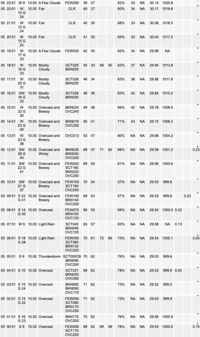
Earlier strong-severe convection has–temporarily at least– cleared our area. In its wake, a robust surface warm front is moving northward and seems to have just about cleared our entire forecast area. Strong southerly winds will continue to hold temperatures pretty steady overnight, and some sporadic gusts to 30-40 mph will be possible, primarily well south of I-80 in the vicinity of slightly steeper near-surface lapse rates.
While Lincoln and Davenport`s evening soundings reveal strongly capped environments to surface-based parcels, the persistent feed of southerly winds pushing low to mid 60 degree dewpoints northward will result in incrementally diminishing MLCIN through the overnight hours, with further lifting/cooling of the based on the lingering EML plume ahead of the surface low expected to result in values lowering enough to support renewed development and/or intensification of ongoing convection.
Currently, regional radar loops reveal outflow continues to push ahead of the convective complex north of I-80 in eastern Iowa with a persistent diminishing trend noted to updraft intensity. Increased forcing may allow for additional storm development immediately along and behind this feature as it drifts into our area after about 4 AM. While cells may ultimately remain disorganized, they will be entering an environment with increased MUCAPE with eastward extent, so any supercells that are able to sustain themselves will be capable of producing a few instances of large hail and perhaps a severe wind gust. Think the tornado threat in the immediate term should remain muted, although we`ve recently seen some signs of increasing low- level rotation on the cell NW of the Quad Cities.
Eyeing an additional area of convection farther south–currently developing into western Missouri on the southeastern flanks of a 150 kt jet streak. Conceptually, this activity seems like the area for us to watch for later this morning for the main severe potential. Timing these features out, getting an arrival into Livingston/Southern La Salle Counties around 600-630 AM, and through our NW Indiana counties by 9-10 AM. Obviously, this is a climatologically unfavorable time for severe weather in our area, but this may be offset largely by the already only weakly-capped environment and expected strong attendant linear forcing. Always tough to figure out how these scenarios will play out, but see an potential (given enough continued maturing of this SW cluster) with the strongly-sheared parameter space for a severe threat, particularly across the southeastern half if not 2/3rds of our forecast area during rush hour. Surface winds ahead of this complex look pretty veered (SWly) which will cut down on eSRH a bit, although with 60 kts presence at 1 km, this may not matter too much with 300+ m2/s2 values advertised by incoming guidance. One wildcard will be whether outflow currently meandering southeastward across central Missouri and also into NW Illinois will get ahead of activity sufficiently to curtail surface-based inflows. If this happens, the severe risk would likely be muted in our area. However, given the recent trends noted on the lead supercell. Any discrete/semi-discrete cells would also carry an attendant large hail threat.
Activity looks to largely clear our forecast area by 10-11 AM. The next question is whether additional activity sprouts on the actual cold front which will lag this morning convection by a few hours. It seems possible that things get overturned sufficiently that the front will not convect as readily. At this time, the RAP is the most aggressive firing additional (low-topped) storms on the front, with better chances looking to occur more into Indiana through mid-late afternoon.
Gusty non-thunderstorm will also develop today. An initial “pop” immediately ahead of the cold front/departing convection appears possible as mixing into the lingering 50-55 kt low-level jet occurs. This will be followed by general 35-45 mph gusts through the afternoon.
Quieter conditions expected into Thursday although gusty westerly winds will continue. Deeper mixing within the drying airmass will likely support afternoon RHs falling into the 25-35 percent range which will support a slightly elevated fire danger within the breezy post-frontal airmass.
Carlaw/NWS Chicago
