
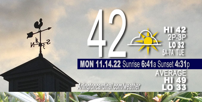
MONDAY Hi 41-42, partly sunny, winds NW to W to SSE, 3 to 7 MPH
NWS CHGO | NWS HRLY | /NWSchicago | 🌡
ARLINGTON HEIGHTS WEATHER
▴ forecast7 (Arl. Hts.) | RADAR | WIDE RADAR
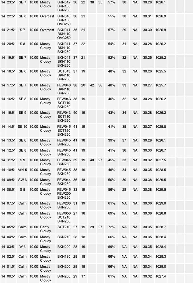
⏪ Hrly Data Table | Hrly Future Graph ⏩
IMPORTANT NOTE ON NWS DATA
⏪ Hrly Data Table | Hrly Future Graph ⏩
======================
Monday Nov. 14, 2022 …
Weather hazards expected…
Limited Snow Risk overnight Monday-Tuesday (after 2:00 a.m. in Arlington Heights and northwest suburbs). Increasing potential for accumulating snowfall with impacts to the Tuesday morning commute appearing probable due to light accumulations, primarily on untreated and elevated surfaces (bridges and overpasses).
Total snow accumulation from Tuesday 2 a.m. to Wednesday at 6 a.m. forecast at 1.3 inches on grassy surfaces, and lesser amount — possibly 0.5 to 0.7 inches — on pavement, roadways, driveways and sidewalks.
Wind shift from NW to SSE as high pressure departs to the east, and low press approaches from the west.
Hello mobile users! If you encounter mobile “unfriendly” weather page, turn your phone sideways for a better view.
======================
Hazardous Weather Outlook
National Weather Service Chicago/Romeoville IL
423 AM CST Mon Nov 14 2022
Winnebago-Boone-McHenry-Lake IL-Ogle-Lee-De Kalb-Kane-DuPage- La Salle-Kendall-Grundy-Kankakee-Livingston-Iroquois-Ford- Northern Cook-Central Cook-Southern Cook-Northern Will- Southern Will-Eastern Will-Lake IN-Porter-Newton-Jasper-Benton- 423 AM CST Mon Nov 14 2022 /523 AM EST Mon Nov 14 2022/
This Hazardous Weather Outlook is for portions of North Central Illinois…Northeast Illinois and Northwest Indiana.
.DAY ONE…Today and Tonight.
Weather hazards expected…
Limited Snow Risk late tonight.
DISCUSSION 1…
Snow is expected late tonight into Tuesday morning. Some light accumulations are likely and may result in slick road surfaces, resulting in travel impacts during the Tuesday morning commute.
.DAYS TWO THROUGH SEVEN…Tuesday through Sunday.
Tuesday… Limited Snow Risk
Wednesday afternoon and evening… Limited Snow Risk.
DISCUSSION 2:
Snow will continue on Tuesday, but warming temperatures are expected to limit accumulations on road surfaces during the afternoon.
Scattered snow showers are expected Wednesday afternoon and evening. The heavier snow showers could result in reduced visibilities and some localized accumulation. Lake effect snow showers will develop across parts of Northwest Indiana.
O’HARE FORECAST …
Forecast Beginning Monday, Nov. 14, 2022
Monday: Partly sunny, with a high near 41. Calm wind becoming south southeast around 5 mph in the morning.
Monday Night: A 30 percent chance of snow, mainly after 5am. Mostly cloudy, with a low around 32. East wind around 5 mph.
Tuesday: Snow before 1pm, then snow, possibly mixed with rain. High near 37. East wind 5 to 10 mph. Chance of precipitation is 90%. New snow accumulation of less than one inch possible.
Tuesday Night: Snow showers, possibly mixed with rain, becoming all snow after 7pm. Low around 33. Northwest wind around 5 mph, with gusts as high as 10 mph. Chance of precipitation is 90%. New snow accumulation of less than a half inch possible.
Wednesday: Snow showers likely, mainly after 1pm. Mostly cloudy, with a high near 39. Northwest wind 5 to 10 mph. Chance of precipitation is 70%.
Wednesday Night: Snow showers likely before 7pm, then flurries with a chance of snow showers after 7pm. Mostly cloudy, with a low around 25. Chance of precipitation is 70%.
Thursday: Flurries with a slight chance of snow showers, mainly before 7am, then a chance of snow showers after 1pm. Mostly cloudy, with a high near 32. Chance of precipitation is 30%.
Thursday Night: A chance of snow showers before 7pm. Mostly cloudy, with a low around 17.
Friday: Partly sunny, with a high near 25.
Friday Night: Mostly cloudy, with a low around 16.
Saturday: Partly sunny, with a high near 28.
Saturday Night: Partly cloudy, with a low around 14.
Sunday: Sunny, with a high near 31.


CHICAGOWEATHERSTATION.COM

ChicagoWeatherStation.com I O’Hare Normal Temps/Precip I O’Hare Record Temps, Precip, Snow
LIVE RADAR | STORM TRACKS | UNISYS US IR SAT | UNISYS Midwest IR SAT | UNISYS More IR SAT
WunderMap® with Temperature/Wind Data || Google: Arlington Heights Area Temps | US TEMPS
Full Screen Motion Weather Radar (Wunderground.com)
Midwest Cloud Cover with Arlington Heights Weather Forecast
ChicagoWeatherStation.com I O’Hare Normal Temps/Precip I O’Hare Record Temps, Precip, Snow
SUNLIGHT DATA FOR SECURITY, TRAFFIC SAFETY, AND SPORTS
SunCalc.net data with solar azimuth and trajectory, times for dawn, sunrise, solar noon, sunset, dusk …
NIGHT SKY THIS MONTH …
Backyard stargazers get a monthly guide to the northern hemisphere’s skywatching events with “Tonight’s Sky.” Check the night sky objects for this month and past months in the playlist from the Space Telescope Science Institute YouTube channel (Musical track The Far River written by Jonn Serrie, from the album And the Stars Go With You courtesy of New World Music Ltd).
Get updates from The Cardinal ALL NEWS FEEDS on Facebook. Just ‘LIKE’ the ‘Arlington Cardinal Page (become a fan of our page). The updates cover all posts and sub-category posts from The Cardinal — Arlingtoncardinal.com. You can also limit feeds to specific categories. See all of The Cardinal Facebook fan pages at Arlingtoncardinal.com/about/facebook …
Help fund The Cardinal Arlingtoncardinal.com/sponsor
Area Forecast Discussion…CORRECTED
National Weather Service Chicago/Romeoville, IL
538 AM CST Mon Nov 14 2022
.SHORT TERM… Issued at 255 AM CST Mon Nov 14 2022
Through Tuesday…
Our briefly quiescent weather pattern will be coming to an end tonight as we head into a pretty active stretch late tonight through the end of the week. The salient talking points through Tuesday night are:
– Increasing potential for accumulating snowfall with impacts to the Tuesday morning commute appearing probable due to light accums, primarily on untreated and elevated surfaces.
– Some threat for brief convectively-enhanced rates within a narrow f-gen band as snow onsets. Uncertainty were this may set up, but most likely south of I-80 and favoring the Kankakee River Valley area.
– Continued signal for lake-enhanced snow developing through Tuesday afternoon across northern Illinois. Marginal surface temperatures casts uncertainty on degree of roadway accumulations into the afternoon/evening commute.
– Warm water temps and onshore flow likely to mute snow accums near the lake across NE Illinois.
Quiet and a smidge warmer today with increasing cloud cover through the afternoon. A lead shortwave will scoot through Minnesota and NW Wisconsin, but any deeper top-down saturation will be relegated well to our north and west.
The main driver of our incoming inclement weather is a robust PV anomaly presently pinwheeling eastward across New Mexico and is forecast to be translating into central Illinois late tonight. Large scale forcing looks fairly appreciable with this disturbance, with 60-80 m/12 hour height falls and strong Q-vector convergence maximizing south of roughly I-80 into Tuesday morning. An antecedent wedge of dry air in the 600-900 mb layer results in some uncertainty regarding the onset of initial snow. That said, continue to note static stability reductions centered just beneath 500 mb as this wave arrives and at least transient/loosely-organized f-gen circulations developing in regional cross sections. While instability and f-gen forcing looks overall more foreboding across Oklahoma and Missouri, there is some concern locally that convective processes may yield a pretty quick saturation of the aforementioned dry layer and a threat for locally-enhanced snowfall rates as system snow overspreads from the southwest to northeast.
Overall, individual parameters are not as concerning as this past Saturday`s event (which dropped pockets of 6-8″ of snow just south of the St. Louis Metro), with omega/UVV not quite co-located with the heart of the DGZ, fairly modest moisture (700 mb mixing ratios near 2 g/kg), and f-gen and jet circulations not as well put together/cohesive. Still, the presence of pockets of upright instability means we`ll need to watch this closely. Think there`s a potential for a burst of heavier snowfall in narrow/streaky bands to develop south of I-80 after 2-3 AM or so in our far south counties, spreading northeast from there into northwest Indiana through 5-7 AM. Initially above-freezing road temperatures should result in some initial melting, but bridges/overpasses will be susceptible to quick coatings as activity presses northeastward. Immediately to the north of any f-gen-driven snow, mesoscale subsidence could result in a local minima in activity, but we should see a gradual expansion of steady but light (hourly rates <0.5"/hour) snow across the rest of the forecast area/northern Illinois through the tail end of the commute. Through Tuesday afternoon, while light snow will probably persist south of I-80, snow quality will degrade markedly as lift weakens and saturation through the DGZ eases. To the north, signal in guidance for lake-enhanced precipitation is a bit better, although onshore winds off a 50+ degree lake will undoubtedly markedly cut into accumulation potential near the lakeshore (including Chicago). Wetbulb temperatures are also forecast to rise above freezing during this time which should help limit the potential for main thoroughfare accumulations. The one fly in the ointment here is the potential for heavier rates to be realized as thermodynamic parameters improve through the late afternoon and Tuesday evening as is starting to be advertised more strongly by the HRRR and NAMNest. For this forecast package, snowfall amounts through Tuesday night look to generally be in the 1-2 inch range (no material change from the day shift`s forecast), but swaths of 2-4 inch amounts appear in the cards across far northern Illinois once you get more than 20-30 miles away from the mild lake influence. Lake effect/enhancement will then progressively shift into northwest Indiana through the night. No winter weather headlines at this time owing to the generally lower snow amounts and uncertainty regarding placement or occurrence of transient f-gen forced snow. However, potential for things to go from just wet on main roads to snow-covered at bridges and overpasses suggests impacts to travel, especially Tuesday morning. Plus, this being the first widespread accumulating snowfall (even if on the lighter side) further increases the potential for travel challenges. Will continue to highlight this in our graphical messaging suite this morning. Carlaw/NWS Chicago
