
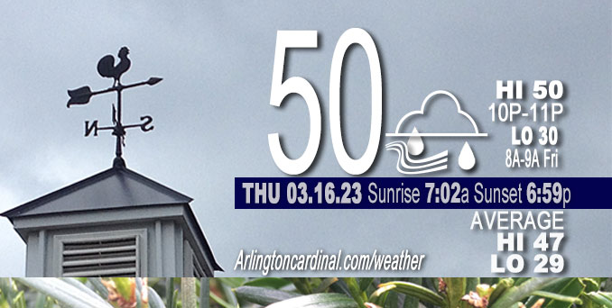
Thursday Hi 50, mostly sunny then mostly cloudy 5p, winds SSE to SSW to S, 8 to 16 MPH, G13 to 31 to 28 MPH continuing Friday
NWS CHGO | NWS HRLY | /NWSchicago | 🌡
ARLINGTON HEIGHTS WEATHER
▴ forecast7 (Arl. Hts.) | RADAR | WIDE RADAR
⏪ Hrly Data Table | Hrly Future Graph ⏩
IMPORTANT NOTE ON NWS DATA
⏪ Hrly Data Table | Hrly Future Graph ⏩
Hello mobile users! If you encounter a mobile “unfriendly” weather page, turn your phone sideways for a better view.
======================
Thursday and Thursday Evening …
Weather Hazards expected …
Limited Non Thunderstorm Wind Risk.
DISCUSSION…
Southerly winds will gust as high as 35 mph today, with this evening possibly realizing some gusts over 40 mph east of I-55 and south of I-80.
======================
O’HARE FORECAST …
Forecast Beginning Thursday, Mar. 16, 2023
Thursday: Periods of showers, mainly after 1pm. Steady temperature around 47. South wind around 15 mph, with gusts as high as 30 mph. Chance of precipitation is 80%. New precipitation amounts between a tenth and quarter of an inch possible.
Thursday Night: Periods of showers, mainly before 3am, then a chance of sprinkles with isolated showers after 5am. Low around 31. Blustery, with a south wind 15 to 25 mph becoming west northwest after midnight. Winds could gust as high as 40 mph. Chance of precipitation is 100%. New precipitation amounts between a quarter and half of an inch possible.
Friday: A chance of flurries before 9am. Cloudy, then gradually becoming mostly sunny, with a steady temperature around 34. Breezy, with a west northwest wind around 25 mph, with gusts as high as 40 mph.
Friday Night: Partly cloudy, with a low around 16. Wind chill values as low as zero. Breezy, with a west wind around 20 mph, with gusts as high as 30 mph.
Saturday: A chance of flurries before 1pm, then a chance of flurries with a slight chance of snow showers after 1pm. Mostly cloudy, with a high near 28. Breezy, with a west northwest wind around 20 mph, with gusts as high as 35 mph. Chance of precipitation is 20%.
Saturday Night: Partly cloudy, with a low around 20. Blustery.
Sunday: Sunny, with a high near 38.
Sunday Night: Mostly clear, with a low around 25.
Monday: Sunny, with a high near 46.
Monday Night: Partly cloudy, with a low around 30.
Tuesday: Mostly sunny, with a high near 50.
Tuesday Night: Mostly cloudy, with a low around 36.
Wednesday: A chance of showers. Partly sunny, with a high near 53.


CHICAGOWEATHERSTATION.COM

ChicagoWeatherStation.com I O’Hare Normal Temps/Precip I O’Hare Record Temps, Precip, Snow
LIVE RADAR | STORM TRACKS | UNISYS US IR SAT | UNISYS Midwest IR SAT | UNISYS More IR SAT
WunderMap® with Temperature/Wind Data || Google: Arlington Heights Area Temps | US TEMPS
Full Screen Motion Weather Radar (Wunderground.com)
Midwest Cloud Cover with Arlington Heights Weather Forecast
ChicagoWeatherStation.com I O’Hare Normal Temps/Precip I O’Hare Record Temps, Precip, Snow
SUNLIGHT DATA FOR SECURITY, TRAFFIC SAFETY, AND SPORTS
SunCalc.net data with solar azimuth and trajectory, times for dawn, sunrise, solar noon, sunset, dusk …
NIGHT SKY THIS MONTH …
Backyard stargazers get a monthly guide to the northern hemisphere’s skywatching events with “Tonight’s Sky.” Check the night sky objects for this month and past months in the playlist from the Space Telescope Science Institute YouTube channel (Musical track The Far River written by Jonn Serrie, from the album And the Stars Go With You courtesy of New World Music Ltd).
Get updates from The Cardinal ALL NEWS FEEDS on Facebook. Just ‘LIKE’ the ‘Arlington Cardinal Page (become a fan of our page). The updates cover all posts and sub-category posts from The Cardinal — Arlingtoncardinal.com. You can also limit feeds to specific categories. See all of The Cardinal Facebook fan pages at Arlingtoncardinal.com/about/facebook …
Help fund The Cardinal Arlingtoncardinal.com/sponsor
Area Forecast Discussion
National Weather Service Chicago/Romeoville, IL
621 AM CDT Thu Mar 16 2023
.SHORT TERM… Issued at 254 AM CDT Thu Mar 16 2023
Through Friday…
Key Messages:
* Periods of rain showers this afternoon and evening
* Breezy today and this evening; brief period of 40+ mph gusts possibly south of I-80 and east of I-55 this evening
* Blustery and colder overnight into Friday with gusts to 40 mph
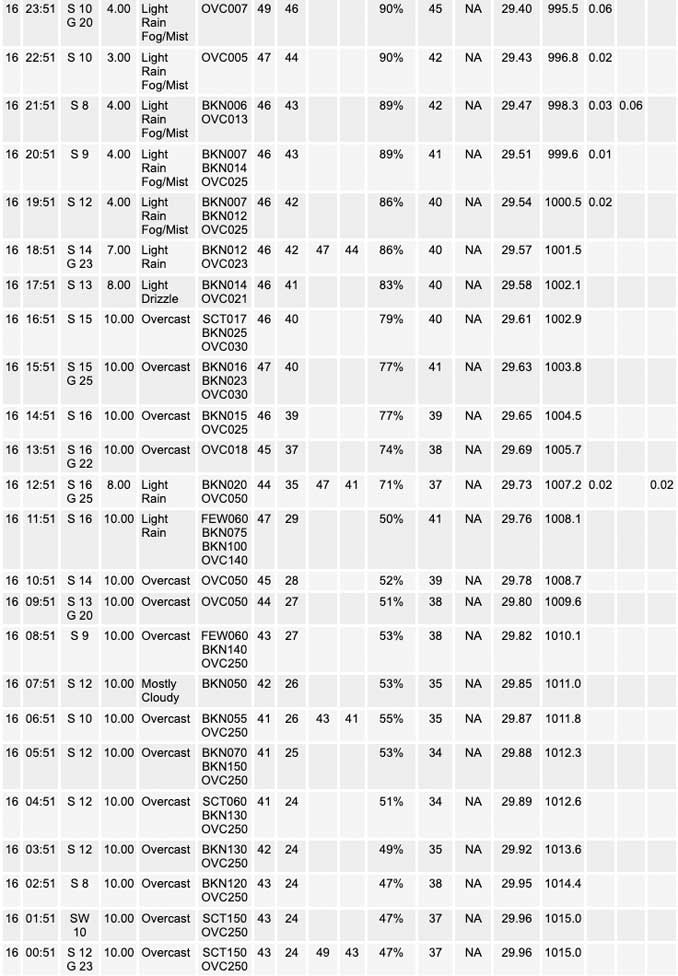
Upper level ridging temporarily resides over the area early this morning, with CONUS satellite water vapory imagery showing the upstream trough across the Rockies. Broad diffluence ahead of this will spread over the Mississippi Valley through today as will the nose of the 50 kt low-level jet extending northeast from east Texas. Multiple small, upper level perturbations within the general southwest flow aloft are forecast to drift across the area and result in somewhat transient areas of concentrated forcing for showers. The nature of this through the daytime hours does not necessarily point toward blanket coverage of rain, and instead periodic afternoon showers.
Upper forcing peaks during the evening hours with increasing positive vorticity advection and the arrival of the left exit region of a 105 kt upper jet. This is also immediately ahead of the surface low around 995 mb and its attendant cold front, so the draw of column moisture is maximized and focused. This should result in the most widespread shower activity in the 7 PM to 1 AM period, though even then there might be some passing gaps in coverage. The thunder potential is non-zero along and south of I-80 with slightly steeper elevated lapse rates of 7C/km than forecast 24 hours ago and being at the nose of the low-level jet. Confidence remains too low to include any thunder mention in the forecast, and CAMs add support to this with a focus for greatest high dBZ and elevated instability being well south of the CWA.
Otherwise today and this evening, southerly winds within the general pressure fall regime will yield gusts to 25 to 30 mph, ushering in highs in the upper 40s north to lower 50s Chicago and south. One area that could realize higher winds is south of I-80 late today and this evening, as the 925-950 mb winds peak near 45 kt. Some guidance also indicates a pressure fall maximum passing through that area during the same time. With temperatures likely not to fall this evening and possibly even rising a couple degrees within the low-level warm advection, some mixing down of the higher gusts to 40 mph or even slightly over might be realized south of I-80. Overall low confidence on that.
As the trough swings neutrally to even slightly negatively titled over the Great Lakes region late tonight, a surface cold front will come rushing through between 11 PM and 3 AM. This will end the rain showers though stray sprinkles or “low quality” flurries may be seen into the daybreak period. Strong pressure rises and an initial surge of cold advection will allow for momentum transfer of higher northwesterly wind gusts, including a few over 40 mph, overnight through early Friday morning. Winds are then favored to settle in to frequent gusts of 30 to 35 mph with any higher likely becoming very sporadic during most of the day. After about a 15-18F temperature fall in 6 hours overnight, readings will only climb slightly from there on Friday. Some sun is forecast with stratocumulus to be quite thin at that point.
MTF/NWS Chicago
