
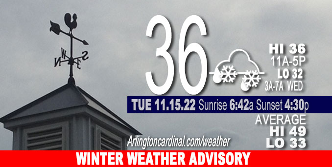
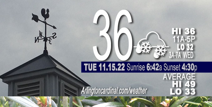
TUESDAY Hi 36, mostly cloudy, snow, winds E to N to NE to NW, 9 to 3 to 6 MPH
NWS CHGO | NWS HRLY | /NWSchicago | 🌡
ARLINGTON HEIGHTS WEATHER
▴ forecast7 (Arl. Hts.) | RADAR | WIDE RADAR
⏪ Hrly Data Table | Hrly Future Graph ⏩
IMPORTANT NOTE ON NWS DATA
⏪ Hrly Data Table | Hrly Future Graph ⏩
======================
Tuesday and Tuesday Night …
No weather hazards expected…
DISCUSSION…
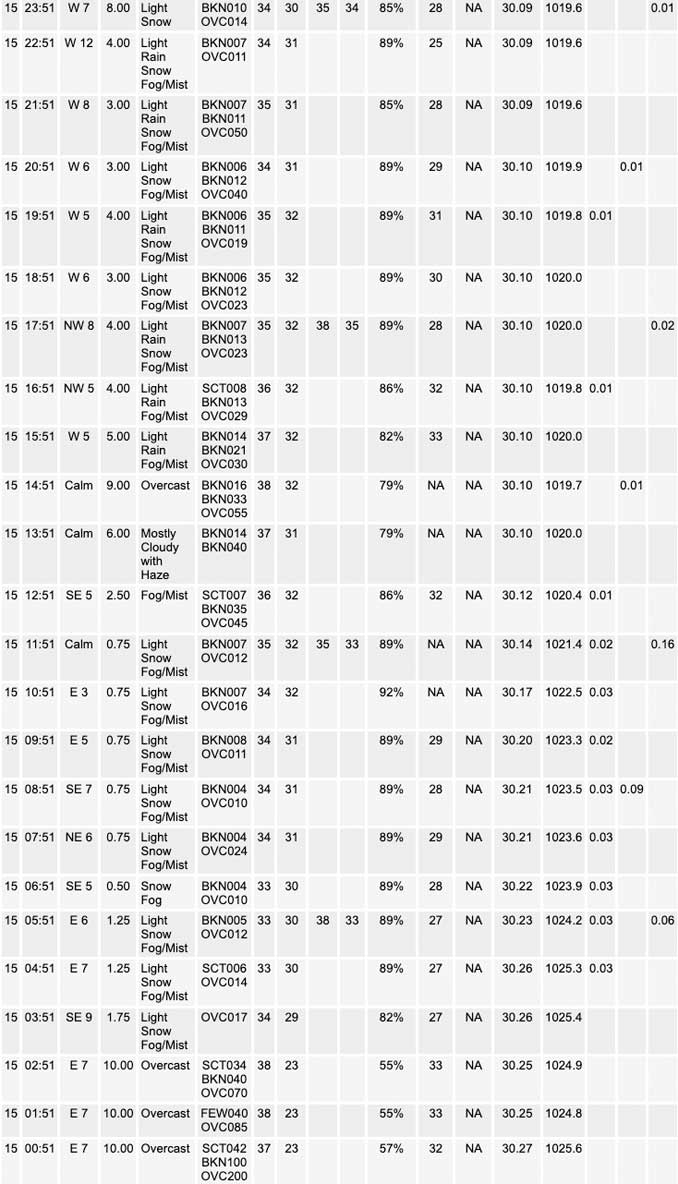
Snow overspread the region early Tuesday morning, into the I-80/88 corridors (including Chicago) through 5-6 AM, and to the Wisconsin state line shortly thereafter.
– Initial melting with pavement temperatures above freezing, but coatings developing quickly on untreated and elevated surfaces in some areas.
– Snow accumulations and road impacts ending south of I-80 by 11 AM/noon as snow quality degrades (or ends) and temperatures warm.
– Continued higher-than-normal uncertainty regarding snow amounts and potential for main roadway accumulations across NE Illinois as lake-enhancement develops through mid-morning and persists through the afternoon. Main uncertainties due to warm lake temperatures, marginal inland surface temperatures near 32-34, and a significant spread in QPF (Quantitative Precipitation Forecast) across the high-res guidance suite.
– Slightly increased snow amounts with this forecast for locales north and east of I-90 and to about 5-10 miles from the lake, with totals through 6 AM Wednesday in the 3 to 5 inch range with some very localized higher amounts across interior Lake, McHenry, and northwest Cook Counties.
– Potential for snowfall rates to approach ( 1 inch/hour this afternoon and evening across NE Illinois as lake-enhanced snow begins to pivot southward along an inverted trough. Associated travel impacts possible for the afternoon/evening rush.
– No alterations to the inherited Winter Weather Advisory segments or start/end times.
– Accumulating lake effect snowfall transitioning into parts of Lake and Porter counties in NW Indiana tonight and Wednesday evening. Significant uncertainty in placement of a potential dominant LES band. Threat for more significant accumulations currently across La Porte County.
– Gusty snow showers developing across the rest of the region Wednesday with additional “streaky” accumulations.
======================
Winter Weather Advisory
URGENT – WINTER WEATHER MESSAGE
National Weather Service Chicago IL Issued by National Weather Service Lincoln IL 1105 AM CST Tue Nov 15 2022
McHenry-Lake IL-DuPage-Northern Cook-Central Cook- Including the cities of Crystal Lake, Algonquin, McHenry, Woodstock, Waukegan, Buffalo Grove, Mundelein, Gurnee, Naperville, Wheaton, Downers Grove, Lombard, Carol Stream, Evanston, Des Plaines, Schaumburg, Palatine, Northbrook, Chicago, Cicero, Oak Lawn, Oak Park, and La Grange 1105 AM CST Tue Nov 15 2022
…WINTER WEATHER ADVISORY REMAINS IN EFFECT UNTIL 6 AM CST WEDNESDAY…
* WHAT…Periods of snow, including lake effect snow showers, with slushy accumulations on roadways expected. Total snow accumulations of 2 to 5 inches. Locally higher amounts near 6 inches are possible across interior portions of Lake, northwest Cook, and McHenry counties. Limited snow accumulations are expected along the immediate Lake Michigan shoreline.
* WHERE…McHenry, Lake IL, DuPage, Northern Cook and Central Cook Counties.
* WHEN…From 6 AM this morning to 6 AM CST Wednesday.
* IMPACTS…Plan on slippery road conditions including during parts of this evening`s commute.
* ADDITIONAL DETAILS…Snow rates may exceed 1 inch per hour from late this afternoon to early Wednesday morning due to lake effect snow showers.
PRECAUTIONARY/PREPAREDNESS ACTIONS…
Slow down and use caution while traveling.
The latest road conditions for Illinois can be obtained on the internet at www.gettingaroundillinois.com.
O’HARE FORECAST …
Forecast Beginning Tuesday, Nov. 15, 2022
Tuesday: Snow before 2pm, then snow, possibly mixed with rain. High near 36. East wind 5 to 10 mph. Chance of precipitation is 100%. Total daytime snow accumulation of 1 to 3 inches possible.
Tuesday Night: Snow. Low around 32. Northeast wind around 5 mph becoming west northwest in the evening. Chance of precipitation is 90%. New snow accumulation of 1 to 3 inches possible.
Wednesday: A chance of snow showers before noon, then snow showers likely, possibly mixed with rain between noon and 3pm, then snow showers likely after 3pm. Cloudy, with a high near 36. West northwest wind 5 to 10 mph, with gusts as high as 15 mph. Chance of precipitation is 60%. New snow accumulation of less than one inch possible.
Wednesday Night: Flurries with a chance of snow showers before midnight, then flurries after midnight. Mostly cloudy, with a low around 26. West wind around 10 mph, with gusts as high as 15 mph. Chance of precipitation is 30%.
Thursday: A chance of flurries before noon, then a slight chance of snow showers after noon. Mostly cloudy, with a high near 33. West southwest wind 10 to 15 mph, with gusts as high as 25 mph. Chance of precipitation is 20%.
Thursday Night: A 30 percent chance of snow showers, mainly before midnight. Mostly cloudy, with a low around 18.
Friday: Mostly cloudy, with a high near 25.
Friday Night: Mostly cloudy, with a low around 14.
Saturday: Partly sunny, with a high near 28.
Saturday Night: Partly cloudy, with a low around 14.
Sunday: Mostly sunny, with a high near 27.
Sunday Night: Mostly clear, with a low around 18.
Monday: Mostly sunny, with a high near 35.


CHICAGOWEATHERSTATION.COM

ChicagoWeatherStation.com I O’Hare Normal Temps/Precip I O’Hare Record Temps, Precip, Snow
LIVE RADAR | STORM TRACKS | UNISYS US IR SAT | UNISYS Midwest IR SAT | UNISYS More IR SAT
WunderMap® with Temperature/Wind Data || Google: Arlington Heights Area Temps | US TEMPS
Full Screen Motion Weather Radar (Wunderground.com)
Midwest Cloud Cover with Arlington Heights Weather Forecast
ChicagoWeatherStation.com I O’Hare Normal Temps/Precip I O’Hare Record Temps, Precip, Snow
SUNLIGHT DATA FOR SECURITY, TRAFFIC SAFETY, AND SPORTS
SunCalc.net data with solar azimuth and trajectory, times for dawn, sunrise, solar noon, sunset, dusk …
NIGHT SKY THIS MONTH …
Backyard stargazers get a monthly guide to the northern hemisphere’s skywatching events with “Tonight’s Sky.” Check the night sky objects for this month and past months in the playlist from the Space Telescope Science Institute YouTube channel (Musical track The Far River written by Jonn Serrie, from the album And the Stars Go With You courtesy of New World Music Ltd).
Get updates from The Cardinal ALL NEWS FEEDS on Facebook. Just ‘LIKE’ the ‘Arlington Cardinal Page (become a fan of our page). The updates cover all posts and sub-category posts from The Cardinal — Arlingtoncardinal.com. You can also limit feeds to specific categories. See all of The Cardinal Facebook fan pages at Arlingtoncardinal.com/about/facebook …
Help fund The Cardinal Arlingtoncardinal.com/sponsor
Area Forecast Discussion
National Weather Service Chicago/Romeoville, IL
602 AM CST Tue Nov 15 2022
.SHORT TERM… Issued at 217 AM CST Tue Nov 15 2022
Updated at 453 AM CST to add technical details.
Through Wednesday Night…
The bottom lines up front for the forecast through Wednesday are:
– Snow overspreading the region early this morning, into the I-80/88 corridors (including Chicago) through 5-6 AM, and to the Wisconsin state line shortly thereafter.
– Initial melting with pavement temperatures above freezing, but coatings developing quickly on untreated and elevated surfaces.
– Snow accumulations and road impacts ending south of I-80 by 11 AM/noon as snow quality degrades (or ends) and temperatures warm.
– Continued higher-than-normal uncertainty regarding snow amounts and potential for main roadway accumulations across NE Illinois as lake-enhancement develops through mid-morning and persists through the afternoon. Main uncertainties due to warm lake temperatures, marginal inland surface temperatures near 32-34, and a significant spread in QPF across the high-res guidance suite.
– Slightly increased snow amounts with this forecast for locales north and east of I-90 and to about 5-10 miles from the lake, with totals through 6 AM Wednesday in the 3 to 5 inch range with some very localized higher amounts across interior Lake, McHenry, and northwest Cook Counties.
– Potential for snowfall rates to approach ( 1 inch/hour this afternoon and evening across NE Illinois as lake-enhanced snow begins to pivot southward along an inverted trough. Associated travel impacts possible for the afternoon/evening rush.
– No alterations to the inherited Winter Weather Advisory segments or start/end times.
– Accumulating lake effect snowfall transitioning into parts of Lake and Porter counties in NW Indiana tonight and Wednesday evening. Significant uncertainty in placement of a potential dominant LES band. Threat for more significant accumulations currently across La Porte County.
– Gusty snow showers developing across the rest of the region Wednesday with additional “streaky” accumulations.
Snow continues to pile in across Illinois (although dry air is evidently still mostly winning out across northwest Indiana). Initially above-freezing temperatures are cooling readily towards their wetbulbs, and while main thoroughfares remain wet, we`re finally starting to see spotty coatings developing on bridges and overpasses. Forecast soundings and cross sections reveal that the most significant static stability reductions (elucidated by theta-e lapse rates trending towards 1 C/km) will continue to focus pretty much over the I-80/88 corridors here this morning. These values are certainly sufficient to promote slantwise parcel accelerations, and indeed seeing some ephemeral EPV* reductions around 500-400 mb. Magnitudes are not overly concerning, however, so the thinking of more organized–but transient–f-gen bands producing localized bursts of heavier snow seem to be on track (already seeing a few 35+ dBZ returns across east-central La Salle county).
Large scale forcing for ascent eases from south to north through the morning. Saturation becomes more ragged through the DGZ south of I-80 as forcing departs, and as a result snow quality will diminish. Temperatures look to warm enough to even allow some rain to mix in, so travel impacts look to effectively end by late-AM here. Farther north, main big questions marks are what happens with lake-enhancement through the morning and into this evening. HRRR remains exceptionally aggressive, squeezing out 1-1.5 inches of liquid equivalent across northern Cook and Lake counties. Lake parameters are certainly nothing to scoff at (lake-induced CAPE near 500 J/kg, and ELs pushing north of 10 kft through the afternoon), but the reticence for other guidance to produce such significant amounts seems pretty telling). Will note that the HRDPS–the Canadian counterpart to the HRRR–does show similar streaks of localized higher QPF near 1 inch, perhaps a bit farther north straddling the Wisconsin state line.
Variable-density snow depth output from the HRRR definitely blunts the accumulations a bit (likely owing to mild lake influences) with a much smaller region of localized 5-6 inch amounts across interior Lake and northern Cook counties, and this is likely much more representative than a straight 10:1 or using the Kuchera method through the entire event. Additionally, 00z HREF guidance does suggest a potential for snowfall rates to increase this afternoon and evening as lake parameters improve. Taken together, still thinking the HRRR verbatim remains on the hot side, but there does appear to be a better signal for enhanced rates to develop this afternoon and evening, mostly north and east of I-90 and away from the immediately lake front. As mentioned above, did subtly boost snow amounts a bit to account for this. The inherited winter weather advisories handle all of this very well. We`ve hit the message of more impacted travel this afternoon and evening into Chicago a bit harder as a result.
Lake effect shifts into NW Indiana through tonight and Wednesday night. Noting fairly significant spread in guidance regarding the location of either a dominant band or several more loosely- organized ones. The HRRR remains near a western outlier among the guidance suite, with most other output suggest veering lower level winds will eventually guide activity more meaningfully into La Porte/Berrien counties through the day. Too much uncertainty to hoist an advisory as a result, but could very well envision needing one for Porter County this afternoon. Think that warning- level impacts should remain more into IWX`s area at this time.
Inland from the lake, additional snow/snow showers will develo Pthrough the morning and afternoon on Wednesday as a secondary vort lobe pinwheels through. Low-level moisture and lapse rates very supportive of squalls, but winds through the lower troposphere are thankfully pretty weak (15-20 kts or less). Looking at additional “streaky” snow accumulations within any more robust snow showers, and additional amounts in the 0.5 to 1 inch range seem like a good bet, at least on grassy and elevated/untreated surfaces.
Carlaw/NWS Chicago
