
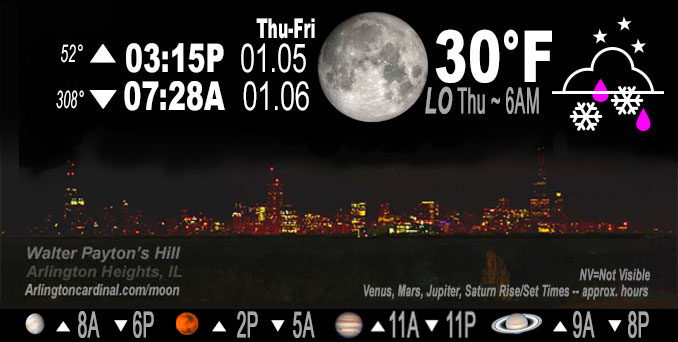
🌔 🌕 🌗 🌑 Waxing Gibbous Moon, freezing drizzle, snow, sky cover overnight Thu. to Fri. 100%, winds WSW to W to WNW, 11 to 9 MPH, G16 to 17 to 15 MPH, Low 30, 6a to 9a
NWS CHGO | NWS HRLY | /NWSchicago | 🌡
ARLINGTON HEIGHTS WEATHER
▴ forecast7 (Arl. Hts.) | RADAR | WIDE RADAR
IMPORTANT NOTE ON NWS DATA
======================
NIGHT FORECASTS …
NOTE 1: Forecast and information text below may refer to a previous night on Arlingtoncardinal.com, and might not be updated until late afternoon, evening, or overnight. However, Night Sky archives on CARDINAL NEWS Magazine include text forecasts that correspond to the lunar phase graphic above.
NOTE 2: Keep in mind lunar rise and set times don’t always correspond with night weather and early morning lows because on some days during the month the moon is visible in the sky predominantly during the daytime hours.
Overnight Thursday/Friday …
Weather Hazards expected …
Radar clear, but risk of slippery surfaces from overnight snow flurries and frozen road surfaces.
DISCUSSION…
A mix of patchy very light snow, drizzle and freezing drizzle (which was on and off overnight until about 4:00 a.m.) may make for a few slick spots on elevated and untreated surfaces early Friday morning across parts of far northeast Illinois and northwest Indiana.
Hello mobile users! If you encounter mobile “unfriendly” weather page, turn your phone sideways for a better view.
======================
O’HARE FORECAST …
Forecast Beginning Thursday Night, Jan. 05, 2023 …
Thursday Night: Scattered snow showers before 11pm, then scattered flurries between 11pm and 1am. Cloudy, with a low around 30. West wind around 10 mph, with gusts as high as 15 mph. Chance of precipitation is 40%.
Friday: Mostly cloudy, with a high near 34. West wind around 10 mph, with gusts as high as 15 mph.
Friday Night: Partly cloudy, with a low around 25. West wind around 5 mph becoming calm in the evening.
Saturday: Mostly sunny, with a high near 37. Light and variable wind becoming east northeast 5 to 10 mph in the morning.
Saturday Night: A 20 percent chance of snow. Mostly cloudy, with a low around 28.
Sunday: A 20 percent chance of snow before noon. Partly sunny, with a high near 37.
Sunday Night: Mostly cloudy, with a low around 27.
Monday: Mostly sunny, with a high near 41.
Monday Night: Mostly cloudy, with a low around 32.
Tuesday: Mostly cloudy, with a high near 39.
Tuesday Night: Mostly cloudy, with a low around 27.
Wednesday: Partly sunny, with a high near 35.
O’Hare forecast archive and hourly weather observations archive are available HERE on the CARDINAL NEWS Magazine.
Arlingtoncardinal.com/moonphases
Arlingtoncardinal.com/nightsky
NIGHT SKY THIS MONTH …
Check the night sky objects for this month and past months in the playlist from the Space Telescope Science Institute YouTube channel Backyard stargazers get a monthly guide to the northern hemisphere’s skywatching events with “Tonight’s Sky” (Musical track The Far River written by Jonn Serrie, from the album And the Stars Go With You courtesy of New World Music Ltd. Musical track The Far River written by Jonn Serrie, from the album And the Stars Go With You courtesy of New World Music Ltd).
Telephoto lens, ISO 100, f/11, Shutter Speed 1/100 to 1/125 for the Moon.
Get updates from The Cardinal ALL NEWS FEEDS on Facebook. Just ‘LIKE’ the ‘Arlington Cardinal Page (become a fan of our page). The updates cover all posts and sub-category posts from The Cardinal — Arlingtoncardinal.com. You can also limit feeds to specific categories. See all of The Cardinal Facebook fan pages at Arlingtoncardinal.com/about/facebook …
Help fund The Cardinal Arlingtoncardinal.com/sponsor
Telephoto lens, ISO 1600, f/11, Shutter Speed 2.5″ for the skyline. The skyline exposure was toned down, and brightness and contrast was adjusted in Photoshop.
Area Forecast Discussion
National Weather Service Chicago/Romeoville, IL
247 AM CST Fri Jan 6 2023
.SHORT TERM… Issued at 247 AM CST Fri Jan 6 2023
Through Saturday…
Main forecast concerns are lingering very light snow/drizzle across far northeast IL and northwest IN early this morning. Some patchy very light freezing drizzle is possible, though no major travel impacts are expected with temps around the freezing mark and precip very light.
Early morning GOES vapor imagery indicates our slow moving upper low had drifted east of the forecast area across the central Great Lakes. Several smaller-scale mid-level vorts were noted within the north-northwest flow west of the low, including one tracking southeast across northern IN, another moving south-southeast across eastern WI and a more sheared short wave further upstream across the eastern Dakotas/western MN. Regional radar composite depicted light returns over eastern WI, northeast IL and northern IN as of 245 am, where slightly deeper low level moisture and forcing associated with deep cyclonic flow and embedded waves were producing light snow, flurries and some patchy drizzle. Temperatures were generally at or above 32F where radar-detectable precipitation was occurring, though some patchy very light freezing drizzle has been noted along the western periphery of the radar returns where temps have fallen to around 30F. Here at our office in Romeoville, some elevated surfaces have accumulated some very thin bumpy ice (like sand paper), though sidewalks and parking lots show no signs of slipperiness. Not expecting any significant impacts to road surfaces early this morning, but will issue a special weather statement shortly to mention some very light patchy freezing drizzle is possible through about sunrise across far northeast IL/northwest IN before precipitation ends shortly thereafter.
Otherwise, shallow low clouds will likely linger across especially east and northeast parts of the forecast area today in a weak cool advection regime, while some partial clearing is possible over far west and southwest sections of the cwa later this afternoon. Skies will remain partly cloudy tonight and into Saturday within a col (intersection of lingering weak surface trough and weak high pressure ridge). Light, convergent surface winds and partly cloudy conditions may allow for patchy fog development tonight in some spots outside the urban core of the Chicago metro.
Surface winds turn light northeast on Saturday, in response to low pressure developing from the Plains into the lower Missouri Valley associated with a mid-level short wave trough (currently seen in vapor imagery over southern CA/NV/AZ) propagating toward the region. Dry weather expected to persist through the day locally however, as moisture return and forcing associated with this approaching wave remain focused south of the forecast area cross the lower Missouri and lower Ohio/Mississippi valleys. Temperatures through the short term period will remain near/slightly above average for early january, with daytime highs in the low-mid 30s and lows tonight in the teens and 20s.
Ratzer/NWS Chicago
